In the 2002 ice storm, in GSP, as bad as it was, there was a lot more sleet than expected! That prevented it from being even more damaging!
-
Hello, please take a minute to check out our awesome content, contributed by the wonderful members of our community. We hope you'll add your own thoughts and opinions by making a free account!
You are using an out of date browser. It may not display this or other websites correctly.
You should upgrade or use an alternative browser.
You should upgrade or use an alternative browser.
Wintry Jan 15-16 Winter Storm Discussion & Obs
- Thread starter SD
- Start date
Anybody have surface maps for 02’? Did we have negative dews into central VA? I seriously doubt it.


GeorgiaGirl
Member
The GEFS might not be fully on board with a low pressure running inland...but I would have to think that it might be closer on the temps?
Which isn't great when we're talking ice.
Which isn't great when we're talking ice.
Nerman
Member
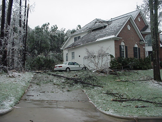
Good read on 2002 if interested
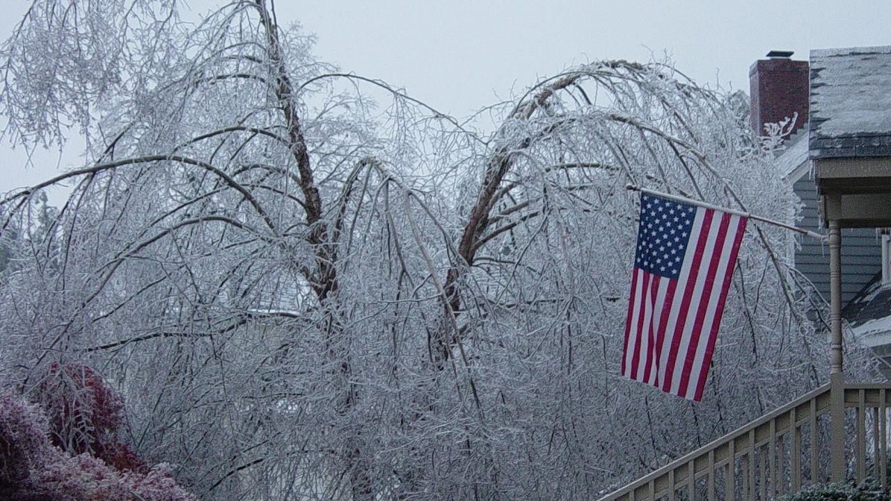
 spectrumlocalnews.com
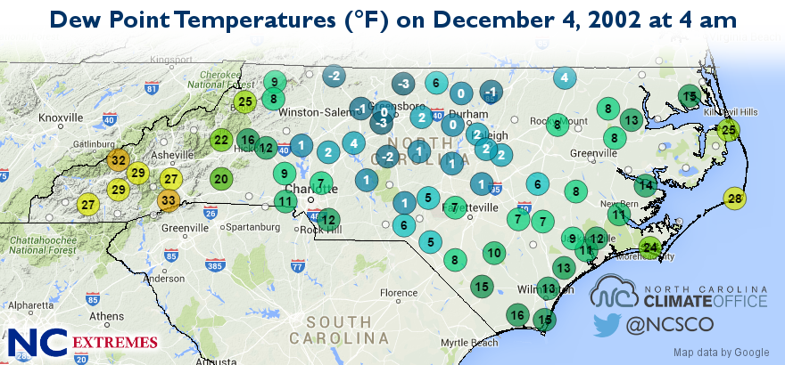
 climate.ncsu.edu
Dew Points: and it was an inland LP
A crippling ice storm struck North Carolina 20 years ago
It took up to 10 days for power to be restored.
spectrumlocalnews.com
NC Extremes: An Ice Storm for the Ages - North Carolina State Climate Office
This post is part of our year-long series about North Carolina's weather extremes. Winter weather in North Carolina can be a fickle thing. When cold air and moisture come together at the right time, the outcome can be an impressive snowstorm. However, even small temperature differences...
climate.ncsu.edu
Dew Points: and it was an inland LP
Last edited:
BelmontWX79
Member
If GFS verified would be catastrophic for Charlotte metro!may be sleet
View attachment 104405

soundings looks like sleet, not frz rain. just need to hope that warm nose isnt stronger than modeled.If GFS verified would be catastrophic for Charlotte metro!
Big trends from a lot of snow on the 85 corridor yesterday, to now sloppy ice storm, could easily trend to just rain! 3-4 days is an eternity in tracking winter storm
I know the models are going to change, but for the I-85 corridor up through NC, I can't imagine it's going to be rain, at least not the non frozen kind.Big trends from a lot of snow on the 85 corridor yesterday, to now sloppy ice storm, could easily trend to just rain! 3-4 days is an eternity in tracking winter storms
Here's what typically happens in CAD events. 1. There is usually a period of front end snow that is under forecast 2. The temps are ALWAYS under estimated...it's always colder. 2. Some, if not ALL models scour the CAD out way too quick. At least that's what my experience has seen. This storm could be a sleet fest for many!
This is actually a pretty solid setup with the CAD. Sfc high to the north tucks in behind the trough / low in SE Canada with -20C 850mb source region temps over Maine (bottom right). The strong southern wave going negative tilt actually adds additional confluent flow running into New England, holding the sfc high in there a little longer than would otherwise be the case.What are the chances that the CAD will get scoured out with the HP sliding off into the Atlantic?
For the CAD to fail, I think we'll need to see a combination of the trough over SE Canada scooting out to the east faster and the southern wave go stronger and farther west. The model depiction of temperatures in the damming region is quite cold as of now


NWMSGuy
Member
Glad to see the GEFS mean increased around the Mid-South.
To add to this another aspect is just how robust that initial FGEN band is… a solid enough thump that puts down a quick 2-4 inches of snow and drops the temps back into the low 20s with undoubtedly help to hold CAD in stronger and longer… it’s just a matter of are the 925s supportive of keeping things mainly sleet and just how much ZR is there. As for freezing rain being a self limiting process, that’s true but if your in the 22-25 degree range when the ZR starts it’s gonna take a while to make it above 32. I can still remember in the December 2002 storm in Concord where I was living at the time, the sleet and snow switched over to freezing rain when the temp was 25 degrees… it wasn’t untilWhile I think the chances of snow are decreasing rapidly, the chances of ice/sleet have significant increased along the 85 corridor from GSP/CLT/RDU, but the UK has a bad bias of scouring out damming events to quick, I’d imagine many CAD areas barely get close to 32 thru the whole storm once the fgen generated precip starts
Natedogg25
Member
Do y’all think the Cad will be strong enough to reach into west ga and EC Alabama?
I don’t think so.Do y’all think the Cad will be strong enough to reach into west ga and EC Alabama?
Natedogg25
Member
Thank youI don’t think so.
Northern Randolph County. Packfan 98, Ollie should have memory of this one if they where around back thenWhere u live?
Sent from my iPhone using Tapatalk
Having the cold air in place in the Carolinas, is already a big, big, win for this potential!!
catastrophic freezing rain model runs have been just as prevalent as the biblical snow outputs the past few years. usually the 1-2" frz rain apocalyptic bullseyes end up being a sleet fest.
NEGaweather
Member
Sent from my iPhone using Tapatalk
Laughable model. Pittsburgh goes from zilch to 18” in one run. Are you kidding me???

LukeBarrette
im north of 90% of people on here so yeah
Meteorology Student
Member
2024 Supporter
2017-2023 Supporter
So will euro cave more into gfs? We will see
Yes, I suspect icing will overperform the modeling. I’m becoming less and less optimistic about our snow chances, but I think this could be a major pinger and/or ZR storm, even out our way.For comparisons sake, freezing rain started at 28 degrees in the 2002 event. You’re telling me that freezing rain could potentially start 3 or 4 degrees colder than that? 2+2 ain’t that hard if you’ve been through enough of these.
The evolution of the storm’s progression from snow to IP to ZR reminds me a lot of Fab Feb ‘14, though not necessarily the synoptic setup.
Showmeyourtds
Member
I'm meh on this one at this point for anyone along I-20, especially near Atlanta. I know that CAD can squeeze its way down into the city sometimes, but I'm thinking that we'll be alright unless those lower DPs squirm down this way. Losing the snow signals that we saw yesterday on the Euro & UKMET hurts, but I think the trend is pretty clear.
Do we bet against this wedge, Chris? @deltadog03
Do we bet against this wedge, Chris? @deltadog03
Snownut
Member
I would be very surprised if those areas doesn’t stay predominantly SnowI see mixed bag potential at times but I don’t believe we’ll see a full fledged ice storm up that way. I’m watching though. Still a lot of time.
Sent from my SM-A526U using Tapatalk
ATLwxfan
Member
Not this time. CAD will be strongerView attachment 104440
We can’t wishcast cold or bittercast warmth. We can say what we know and that is that our mid to long range models very frequently do a lousy job with CAD forecasting and we will know more as we get closer and as the mesoscale models come into range.
Sent from my iPhone using Tapatalk
Z
Zander98al
Guest
Do y’all think the Cad will be strong enough to reach into west ga and EC Alabama?
I think it's a given it being in west Georgia. But also depends on the exact track of the low. CAD is just winds flowing backwards down the apps causing more shallow cold air. Which is hard to pick up nonetheless by models. But from what I've experienced typically it'll get Around to the Northeast side of Birmingham on the edge of the apps. But the more serious CAD is in the Northeast portion of Alabama.I don’t think so.
One thing to remember when comparing potential to the December 2002 storm is the time of the season it’s coming in. That 2002 storm occurred early in December after a mild fall and there were still a lot of leaves on the trees… so that allowed a lot more ice to accrue than what you get on the bare trees we have. Not trying to downplay the threat here, but we just need to remember there were other factors that made that storm so damaging

Dewpoint Dan
Member
I know some say CAD is always underestimated, but I have also seen times when it ended up being warmer than forecast when there's CAD.We can’t wishcast cold or bittercast warmth. We can say what we know and that is that our mid to long range models very frequently do a lousy job with CAD forecasting and we will know more as we get closer and as the mesoscale models come into range.
Sent from my iPhone using Tapatalk
I hear ya, but up this way the trees where bare bones then, save a few brown oak tree leaves that hang on till spring. The surface temps in low 20s coupled with 1.5 of qpf is a bad recipe. Espeacilly if we lose sleet sounding early in the game.One thing to remember when comparing potential to the December 2002 storm is the time of the season it’s coming in. That 2002 storm occurred early in December after a mild fall and there were still a lot of leaves on the trees… so that allowed a lot more ice to accrue than what you get on the bare trees we have. Not trying to downplay the threat here, but we just need to remember there were other factors that made that storm so damaging
Cary_Snow95
Member
Seems like RDU will be on the outer bubble of the true cad dome. Likely snow to sleet to rain
Born and raised in Birmingham so just my .02.....You are more likely to get CAD into East Central AL than you are in the NE part of the state. I am talking about areas like Scottsboro, Guntersville, down to Gadsden are less likely to see CAD than Anniston. It used to happen a lot in the 80's.I think it's a given it being in west Georgia. But also depends on the exact track of the low. CAD is just winds flowing backwards down the apps causing more shallow cold air. Which is hard to pick up nonetheless by models. But from what I've experienced typically it'll get Around to the Northeast side of Birmingham on the edge of the apps. But the more serious CAD is in the Northeast portion of Alabama.
olhausen
Member
So this Is supposedly all snow right? I’d normally be thrilled to see this but operational is not showing anything like this. It seems more likely this will be an ice/ZR threat then snow at this time no? The ens wasn’t showing means anywhere near this for our last snow. This is one of the better means I’ve seen but I don’t feel anywhere near confident that this will become reality. This one just feels like a messy mix. ?

Natedogg25
Member
Thank you I know it times past in some winter situations locally we were colder and in some thunderstorm situations we also colder due to the E or NE winds. That’s why I was asking.I think it's a given it being in west Georgia. But also depends on the exact track of the low. CAD is just winds flowing backwards down the apps causing more shallow cold air. Which is hard to pick up nonetheless by models. But from what I've experienced typically it'll get Around to the Northeast side of Birmingham on the edge of the apps. But the more serious CAD is in the Northeast portion of Alabama.
iGRXY
Member

I've got a feeling that the 50%-70% along the 85 corridor likely where WPC see's the transition zone between more snow and ice starting to setup.
I don't think so...once the CAD locks in and temps in the 20s it will most likely stay put. So, snow to sleet to fzrn.Seems like RDU will be on the outer bubble of the true cad dome. Likely snow to sleet to rain
Nerman
Member
I wasn't wishcasting and agree we need to get closer. I was pointing to the map showing the stronger cad. Like this one. That's all we have.We can’t wishcast cold or bittercast warmth. We can say what we know and that is that our mid to long range models very frequently do a lousy job with CAD forecasting and we will know more as we get closer and as the mesoscale models come into range.
Sent from my iPhone using Tapatalk

TWC just now:
@Parker BIG words from Ray’s weather center. He doesn’t pull out the “big snow” snowman very often. The alarms are sounding for WNC.
“We get a brief lull Friday night into Saturday morning. But all eyes turn to a potent low moving from the Great Plains to North Florida by Sunday morning. It then roars up the East Coast as a classic Nor'Easter.. This system has real potential as a snow-maker for the Southern Appalachians. Light snow may develop during the daytime Saturday into Saturday evening. The bulk of snow comes late Saturday night through Sunday with snow showers lasting well into Monday. Accumulations will be moderate to heavy. I was tempted to pull out the "Big Snow" Snowman-O-Mometer, but give that the culprit low is thousands of miles away in the Eastern Pacific, I decided the uncertainty was too great for such a move today. But beware, this has potential!
“We get a brief lull Friday night into Saturday morning. But all eyes turn to a potent low moving from the Great Plains to North Florida by Sunday morning. It then roars up the East Coast as a classic Nor'Easter.. This system has real potential as a snow-maker for the Southern Appalachians. Light snow may develop during the daytime Saturday into Saturday evening. The bulk of snow comes late Saturday night through Sunday with snow showers lasting well into Monday. Accumulations will be moderate to heavy. I was tempted to pull out the "Big Snow" Snowman-O-Mometer, but give that the culprit low is thousands of miles away in the Eastern Pacific, I decided the uncertainty was too great for such a move today. But beware, this has potential!