Nerman
Member

Don't like that icy look. I would probably pare that back a bit as sleet may be more dominate in the colder areas. Somebody is going to be rocked with heavy freezing rain, though. Combine that with the winds.....
Before I go try to look again for myself...was that a shift south by the Euro on the ice compared to the 0z? Because yipe...
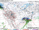
Not what you want to see if you like power. I just can't imagine a thick enough warm nose from the coast up through the foothills of NC that produces that much freezing rain. I'm hoping it's more sleet in the western Carolinas up through the Triad. Now, south and east of there doesn't look good at all.Here's the FRAM...very bad!
ZR down to below Augusta per 12Z Euro/never bet against the wedge,folks!Yea it did shift south on Freezing Rain
Sent from my iPhone using Tapatalk


Looks quite ugly for Northern GA,the Midlands of SC, Central NC and even the western Pee Dee areas. I really do hope the 850 trend colder,so we see more sleet/snow than freezing rain.Here's the FRAM...very bad!
Bring it to papa...mountains of ne ga, nw sc and sw nc get pummeled!
Atl is literally right on the line. Could be mostly rain or a good bit of iceIce fest all the way through all of the Atlanta area per 12Z Euro before it ends as snow: get the candles ready! Never doubt the power of the wedge!
View attachment 104492
Hammering Anderson, GSP with snow! Gonna be a quick 2-3” thump of snow with that look! Good trends today on 12z suites!View attachment 104473
Euro says hard pass on being a follower.

 ️
️
@olhausen , gonna get crushed based on this map! 2 double digit snows back to back! ?
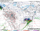
Maybe we can avoid these totals with more sleet?This amount of ice would not be a good situation at all.View attachment 104488
Drops a solid 4-8" before the changeover per the euro.Hammering Anderson, GSP with snow! Gonna be a quick 2-3” thump of snow with that look! Good trends today on 12z suites!
They are on the extreme East side of the classic damming location, depends on wher me the coastal front sets up! Have seen it 50s and rain in RAH and 25 degrees and pounding sleet/ZR in Greenville, SCI continue to have a hard time believing that, if the triangle start the event in the mid 20s as the euro advertises, we are able to bounce back above freezing. A lot of ice in that event
If past experience says anything, it’s that models tend to underdo IP and overdo ZR. Seems like I’ve seen a lot of storms over the years where we got IP at times we were supposed to get ZR.Don't like that icy look. I would probably pare that back a bit as sleet may be more dominate in the colder areas. Somebody is going to be rocked with heavy freezing rain, though. Combine that with the winds.....
so for CAE maybe little ice to rain?
Been there done that, stick around Wake Co a while, it will make you a believer.I continue to have a hard time believing that, if the triangle start the event in the mid 20s as the euro advertises, we are able to bounce back above freezing. A lot of ice in that event
Yeah I fully expect to surge to the upper 30s in Cary. But not sure if it’ll be before .5” of slop and zr has fallenBeen there done that, stick around Wake Co a while, it will make you a believer.
Atl is literally right on the line. Could be mostly rain or a good bit of ice
Been there done that, stick around Wake Co a while, it will make you a believer.
It switches it to rain from Raleigh, up to DC, Baltimore, NY City, and even Boston.Indeed, though I don’t quite see how it takes that track with such strong CAD. Seems like it would need to be another 50-100 miles east? But I’m a modernweenie .
Done it many times in the past this looks pretty climo...bro. look over the nws rah past events page us1 is usually the fence that teeters around freezing with the deeper better cold about 50 miles westI continue to have a hard time believing that, if the triangle start the event in the mid 20s as the euro advertises, we are able to bounce back above freezing. A lot of ice in that event
Yeah we need it tooThat UUL on the Euro is following suit of the gefs. It’s digging south each run.

This has sleetfest written all over it nw of 85.If past experience says anything, it’s that models tend to underdo IP and overdo ZR. Seems like I’ve seen a lot of storms over the years where we got IP at times we were supposed to get ZR.