Avalanche
Member
What are the chances that the CAD will get scoured out with the HP sliding off into the Atlantic?
Does this count freezing rain sleet as snow or is that all snowUKMET

The storm 12-18 hours before it helped with that also. Enhanced the cold air with that wedge. We were supposed to get devestating ice totals in Columbia from that, instead got 8 hours of straight sleet.Hopefully this is a case where instead of FRZN it's IP....I remember in 2014 it was modeled as mostly FRZN and we got a lot more IP.


Yeah, bad newsUK basically is a destructive ice storm/sleet storm from Charlotte through GSO, it warms to 32 by the time the mid level dry slot enters, looks like we’re getting agreement
Sucks because more times than not it seems the Euro follows suit.Losing the Ukie hurts
Yea I would go even farther into Gwinnett. Cad tends to move down to that Snellville/ Norcross ish areaIn Georgia 85N and East from Gainesville North look to be in line for a pretty good Winter storm
Sent from my iPhone using Tapatalk
The tend to move into Atl popular too!Yea I would go even farther into Gwinnett. Cad tends to move down to that Snellville/ Norcross ish area
It’s can if the CAD stays strong.The tend to move into Atl popular too!
The tend to move into Atl popular too!

It's gonna be a nasty weekend any way you slice it.For Georgia I think anybody from Gainesville and NE will get in in the action. Everyone else will be sitting at 34 and rain.
While I think the chances of snow are decreasing rapidly, the chances of ice/sleet have significant increased along the 85 corridor from GSP/CLT/RDU, but the UK has a bad bias of scouring out damming events to quick, I’d imagine many CAD areas barely get close to 32 thru the whole storm once the fgen generated precip startsLosing the Ukie hurts
Not this time. CAD will be strongerFor Georgia I think anybody from Gainesville and NE will get in in the action. Everyone else will be sitting at 34 and rain.

This is the biggest alarm for me with temps in low 20's. If we get overrun up top with waa. It'll rival/pass the Dec 2002 catastrophe. Never want to live an see/expierencing an ice event like that again, especilly with 15 days of BN temps in the heart of winter to follow.QPF is no joke here. GFS has over 2 inches in SC upstate to AVL to CLT. Major winter storm
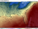
I mean even if the CAD is this strong it's still very borderline (31-32) for Atlanta. To feel comfortable with more wintry precip, you'd like to see it a little colder than that.Not this time. CAD will be strongerView attachment 104440
Depending on if there is a warm nose, yes. The colder sfc temps would only make the potential ice worse.For comparisons sake, freezing rain started at 28 degrees in the 2002 event. You’re telling me that freezing rain could potentially start 3 or 4 degrees colder than that? 2+2 ain’t that hard if you’ve been through enough of these.
To be honest, you can shave about 2 to 3 degrees off since most models underestimate wedges.I mean even if the CAD is this strong it's still very borderline (31-32) for Atlanta. To feel comfortable with more wintry precip, you'd like to see it a little colder than that.

Yep, this was a Saturday deal a few days ago and its gonna be 24 hrs latter. which means Our homemade 50/50 that takes shape tommorrow and heads NE will have another day to move out. Why we will see an inland track now. Gonna get hammered here with 1.0+ of freezing rain with low 20 surface temps. Lived that exact scenerio before and its devastating.I know some might not want to hear this, JB was/is right...as we have been talking about before this week.....we need that confluence to stick in there and keep the block in enough or this would eventually cut inland and......we are starting to see the models cutting inland now.
Pretty serious threat, if any thing has had some threat of rivaling 2002, this is the one, we’re not getting rid of the CAD, maybe the snow, but not the CAD, this thing could cut and it’s still gonna be a nasty ice stormYou can wishcast ice away all you want but the dews tell the story. Low teens into SW VA with teens extending deep into NC. This is shouting trouble from the rooftop. This is NOT a borderline CAD event at this juncture.View attachment 104442
Anybody have surface maps for 02’? Did we have negative dews into central VA? I seriously doubt it.Pretty serious threat, if any thing has had some threat of rivaling 2002, this is the one, we’re not getting rid of the CAD, maybe the snow, but not the CAD, this thing could cut and it’s still gonna be a nasty ice storm
You can wishcast ice away all you want but the dews tell the story. Low teens into SW VA with teens extending deep into NC. This is shouting trouble from the rooftop. This is NOT a borderline CAD event at this juncture.View attachment 104442
I see mixed bag potential at times but I don’t believe we’ll see a full fledged ice storm up that way. I’m watching though. Still a lot of time.Jimmy, you speaking ice for the highlands, cashiers areas? I clearly have no idea the history of this area. I don’t mind some Ice, but definitely want primarily snow.
This is the biggest alarm for me with temps in low 20's. If we get overrun up top with waa. It'll rival/pass the Dec 2002 catastrophe. Never want to live an see/expierencing an ice event like that again, especilly with 15 days of BN temps in the heart of winter to follow.
I see mixed bag potential at times but I don’t believe we’ll see a full fledged ice storm up that way. I’m watching though. Still a lot of time.