Pouring sleet. Woke me up from nap hitting window
-
Hello, please take a minute to check out our awesome content, contributed by the wonderful members of our community. We hope you'll add your own thoughts and opinions by making a free account!
You are using an out of date browser. It may not display this or other websites correctly.
You should upgrade or use an alternative browser.
You should upgrade or use an alternative browser.
Wintry Jan 15-16 Winter Storm Discussion & Obs
- Thread starter SD
- Start date
I think we’ve had a few small flakes mix in over the last hour or so.
Up to 30.2 not much longer now
drfranklin
Member
- Joined
- Dec 1, 2016
- Messages
- 507
- Reaction score
- 749
temp slowly rising, now at 25.9, sleet continues
Birdman said 3-6 for my area. I’m currently sitting at around 12 and this backside is gonna be amazing. You were off birdman, by a lot.
LovingGulfLows
Member
- Joined
- Jan 5, 2017
- Messages
- 1,496
- Reaction score
- 4,086
Big boy banding about to start rotating in soon...hopefully this is where the accumulation can really begin.
iGRXY
Member
I’ve got a feeling the back edge of this going to really over perform. 850s are already crashing into NE Georgia which is ahead of schedule to my understanding. The ULL definitely looks like it is still moving almost due east
Rosie
Member
Rain here.Good ole rain here in Athens. Seeing lots of change over to my west and south
Poppadocacock
Member
Heavy Sleet/Graupel at 1105 am Simpsonville, SC (5 miles south of I85/I385). Storm total 5 plus inches so far
Heelyes
Member
Wow the roads are bad
SimeonNC
Member
Same here, I thought I was crazy at first.I think we’ve had a few small flakes mix in over the last hour or so.
ForsythSnow
Moderator
Moderate snow with visibility dropping. Looks absolutely beautiful.
Certainly taking it’s sweet timeUp to 30.2 not much longer now
drfranklin
Member
- Joined
- Dec 1, 2016
- Messages
- 507
- Reaction score
- 749
possible; radar returns on wundermap seem to be consolidating for our region at the momentI’ve got a feeling the back edge of this going to really over perform. 850s are already crashing into NE Georgia which is ahead of schedule to my understanding. The ULL definitely looks like it is still moving almost due east
Have mercy!View attachment 106694
Mega wedge!
Triplephase93
Member
Mix in Hixson Tn at 36 degrees
TigerStrong
Member
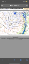
Yep - the longer the ULL can keep moving more ENE and take the 850 low with it, the longer we stay sleet. Also, you can see via SPC meso analysis the secondary surface low is trying to form near the coast around Charleston now as well. Hopefully the primary low will transfer soon.Two things I’m noticing right now
1. It really is looking like to me that CLT metro and north might be able to avoid a major ice accrual. This sleet is holding strong as they column remains below freezing from 925mb down. By the time soundings are supportive of ZR, the dry slot punches in and precip becomes more scattered light or freezing drizzle..
2. Looking at water vapor and radar, it really seems that the ULL is moving further south than modeled and hasn’t cut NE yet. There’s an old saying that “an Upper low is a weatherman’s woe”. They are hard to predict and we’ve seen some do some crazy things compared to forecast over the years.
chattweather
Member
- Joined
- Jan 5, 2022
- Messages
- 12
- Reaction score
- 59
Rain snow mix now in E. Chattanooga, TN, near Hamilton Place.
Alias47
Member
36 and very light cold rain in Etowah County. Just wet with a few small flakes about 25 mins ago.
Sent from my motorola one 5G UW ace using Tapatalk
Sent from my motorola one 5G UW ace using Tapatalk
Heelyes
Member
Heaviest sleet of the day, almost small hail.
Birdman said 3-6 for my area. I’m currently sitting at around 12 and this backside is gonna be amazing. You were off birdman, by a lot.
Scotty was wrong! Reputation nukedBirdman said 3-6 for my area. I’m currently sitting at around 12 and this backside is gonna be amazing. You were off birdman, by a lot.

30/30. Two to go and we can move on
Ice accrual has become more evident to me over the past 30-60min
Heelyes
Member
Not even a drop of liquid yet,fingers crossed
iGRXY
Member
I would rather be right for the majority of the area than your backyard report. i77 does not have big totals.Birdman said 3-6 for my area. I’m currently sitting at around 12 and this backside is gonna be amazing. You were off birdman, by a lot.
LovingGulfLows
Member
- Joined
- Jan 5, 2017
- Messages
- 1,496
- Reaction score
- 4,086
Even though it's the GFS, kind of crazy to see it put a lollipop over my area. Trying to put down nearly 6 inches. Ofc, I don't think it's right.


When your backyard gets just as much! ???? SImpsonville, SCJimmyView attachment 106664View attachment 106666 trouser annihilation

he is also going for around 3” to 6 for most of the mountains and foothills with high elevation! Ice ice View attachment 106040

I would rather be right for the majority of the area than your backyard report. i77 does not have big totals.
Well it’s a lot more than just my backyard you were wrong about. Highlands, cashiers, brevard, Hendersonville…..
I’ll stop there. I don’t want to get booted off this thread.
Heelyes
Member
Visibility has gone down recently and the wind is picking up.
VegasEagle
Member
Huntsville put out a Winter storm warning just now
Power flickers and groaning transformers. I love winter
GaSnowhound
Member
Same here. The very lightest of tiny flakes rt now. Was horse turds for a good while…In a temporary lull here but still all snow. The column is golden for the next round.
32.7
- Joined
- Jan 23, 2021
- Messages
- 4,557
- Reaction score
- 15,063
- Location
- Lebanon Township, Durham County NC
Heavy sleet.
24 degrees
24 degrees
ForsythSnow
Moderator
Temps have been crashing as its been snowing here. 30.9 and still snowing well.


