-
Hello, please take a minute to check out our awesome content, contributed by the wonderful members of our community. We hope you'll add your own thoughts and opinions by making a free account!
You are using an out of date browser. It may not display this or other websites correctly.
You should upgrade or use an alternative browser.
You should upgrade or use an alternative browser.
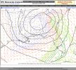
Wintry Jan 15-16 Winter Storm Discussion & Obs
- Thread starter SD
- Start date
Just went to snow in Jasper … 10:43 am
Sleeting hard here right now. Seems like a lot of us are getting this storm
I thought I would miss home but I don’t. My son is in snow above his knees here. This hits different for sure.You will see a lot more where your at. But does a small part of you wish you was home to see it?
Sent from my iPhone using Tapatalk
atlantasweetie
Member
 in SW Atlanta (South Fulton). If it really starts to come down, I will try to post a picture. I'm at 34-35 degrees.
 Sent from my HD1905 using Tapatalk
GeorgiaGirl
Member
Woke up to a low of 35 apparently.
Can't say that I'm upset about missing on the ice, but it is too bad that the 850s were on fire.
Can't say that I'm upset about missing on the ice, but it is too bad that the 850s were on fire.
BHS1975
Member
Sleet really coming down in apex … wondering when freezing rain takes over ? Ground is now covered including the road with sleet!
About 2 more hours. The HRRR folded to the 3k NAM.
Sent from my iPhone using Tapatalk
ForsythSnow
Moderator
Back to all snow here now, just gotta hope for heavy rates.
Sleet in Athens Georgia at this moment
HSVweather
Member
Henagar, AL
It's actually upped total zr here to .36, crazy, doubt that happens but would be a forecast bust if it did. That's warning criteria, again I doubt it but a nod to CAD holding on a little longerNAM 3km still wants to put down .4 of freezing rain from 11-2 … let’s see how that works out .. if that did happen on top of all of this .. good luck Charlie
HSVweather
Member
Green Mountain in south Huntsville
jtgus
Member
Sleet fest here in Gibsonville, NC
NBAcentel
Member
So much sleet
Snowflowxxl
Member
Small but steady flakes here again
transitioning to snow near Harrison Bay - big fatties!
Wow, this is with a foot currently on the ground

Michael_Ballew
Member
West Haralson County close to the state line. Changed over to light snow about an hour ago, flakes are nice size. Temp around 34°. No accumulation yet. NWS has us forecasted for 1-2" of daytime accumulation.
Sent from my SM-N960U using Tapatalk
Sent from my SM-N960U using Tapatalk
Sleep mixing in with flurries, it's coming down extremely hard right now
Stephenb888
Member
Flakes mixing in with rain and sleet in Athens
Mostly sleet here in South Charlotte. Doesn't look like I got too much snow but it is white covering the ground. Not much ice in the trees which is good.

Two things I’m noticing right now
1. It really is looking like to me that CLT metro and north might be able to avoid a major ice accrual. This sleet is holding strong as they column remains below freezing from 925mb down. By the time soundings are supportive of ZR, the dry slot punches in and precip becomes more scattered light or freezing drizzle..
2. Looking at water vapor and radar, it really seems that the ULL is moving further south than modeled and hasn’t cut NE yet. There’s an old saying that “an Upper low is a weatherman’s woe”. They are hard to predict and we’ve seen some do some crazy things compared to forecast over the years.
All rain near downtown Huntsville now. Temperature slowly climbing, up to 34 now.
Shadow of the Apps
Member
Rutherfordton- southern foothills
24/20 13NNE
75/25 snow/sleet
7.5”
24/20 13NNE
75/25 snow/sleet
7.5”
Claycochaser
Member
Yay! Goose feathers here finally!
Doesn’t freezing drizzle accumulate faster?Two things I’m noticing right now
1. It really is looking like to me that CLT metro and north might be able to avoid a major ice accrual. This sleet is holding strong as they column remains below freezing from 925mb down. By the time soundings are supportive of ZR, the dry slot punches in and precip becomes more scattered light or freezing drizzle..
2. Looking at water vapor and radar, it really seems that the ULL is moving further south than modeled and hasn’t cut NE yet. There’s an old saying that “an Upper low is a weatherman’s woe”. They are hard to predict and we’ve seen some do some crazy things compared to forecast over the years.
ChattaVOL
Member
Reports of Thundersnow on Signal Mountain, TN
We switched over to pure snow in Athens Georgia
Snowflowxxl
Member
Ripping here now, easily best rates of day
TigerStrong
Member
It's been primarily sleet here SE of Uptown Charlotte after about an hour of light snow in the beginning. Luckily we've had very little freezing rain so far, so it's been better than expected so far. Probably over two inches of sleet now.
bud006
Member
All snow now, big flakes. Ground starting to whiten up a bit more now. 31 degrees.
--30--
--30--
lusting4Adusting
Member
It's literally the only cold core low in history that has a moderately warmish core. lmao
Chattownsnow
Member

Mega wedge!
Certainly would think with all this sleet and an already slightly coated surface as soon as the Freezing rain kicks in it won’t have a problem building up
- Joined
- Jan 2, 2017
- Messages
- 1,568
- Reaction score
- 4,283
After 3-4" of awesomeness we've had a pile of sleet and zr. Had a little break now sleeping again. Temp 29..backside action to commence.
Neighbor had a big tree blow over right behind my shop..luckily only damage was fence.
Neighbor had a big tree blow over right behind my shop..luckily only damage was fence.
norcarolinian
Member
Heavy sleet and windy. 19.6°

current temp: 36
