-
Hello, please take a minute to check out our awesome content, contributed by the wonderful members of our community. We hope you'll add your own thoughts and opinions by making a free account!
You are using an out of date browser. It may not display this or other websites correctly.
You should upgrade or use an alternative browser.
You should upgrade or use an alternative browser.
Wintry Jan 15-16 Winter Storm Discussion & Obs
- Thread starter SD
- Start date
Ron Burgundy
Member
drfranklin
Member
- Joined
- Dec 1, 2016
- Messages
- 511
- Reaction score
- 760
wind is intense here...haven't heard any thunder...back to overcast skies with a temp of 25.6Well you don’t see that every day. ?
Sleet mixing prolly gonna save us from more ice
GaSnowhound
Member
Snow sleet mix in Social Circle Ga
LovingGulfLows
Member
- Joined
- Jan 5, 2017
- Messages
- 1,499
- Reaction score
- 4,100
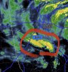
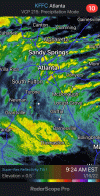
View attachment 106669Come to Papa…
Please tell me that's moving towards the NE....if it is, I'm about to get walloped.
Yeah.. I was hoping that you and I could maybe get a quick inch or so of snow before mixing, but when I haven’t had my yard white since April 2019, this is hard to complain about. I’ll take this over a .5” of ice accrual anytime. Heck, maybe the backside will have some surprises… it does look like the ULL is going further south and east than what models and forecasts were suggestingHoping we can stay out of the freezing rain. This sleet is awesome.
Brother is saying 3-4” in Fountain Inn
RollTide18
Member
Snow beginning to stick to the grass here
Stormlover
Member
just south of Huntsville, Morgan City


Heelyes
Member
It's not often the creek freezes over during the day, pretty impressive sleet storm.
Changing over now! ALL SNOW
- Joined
- Jan 5, 2017
- Messages
- 3,779
- Reaction score
- 5,990
I had a little snow, sleet and light rain over the past thirty minutes. I nice little novelty at the end of long, cold, windy rainy night.
NoSnowATL
Member
Now a sleet/ snow mix. WSB just said my area still on track for 2-4in of snow. About to go buy a Lottery ticket too.
Sctvman
Member
Nearing 1.3” of rain on James Island. Temps still stuck in the upper 40s. All the rain since 1:30am or so
Where are you in HSV? Near downtown we're still at 33 and just now starting to get rain mixing back in.Had a slight dusting this morning, but temp moved back up to 35 and has changed back to all rain. Did see some flakes fly though
dsaur
Member
Just went over to snow.
farleydawg792
Member
Good ole rain here in Athens. Seeing lots of change over to my west and south
JLL1973
Member
At least I got a little . Cams only missed it by 4-6 inches. I was going to upload a pic but it says file too large. I don’t understand why the website does that sometimes and sometimes it doesn’t.
Expect the power outages in SC to quickly hit NC over the next 2-4 hours.
Same here. Let's reel this in!Snow sleet mix in Social Circle Ga
Wind still north but temp climbing. Up to 29.
lusting4Adusting
Member
I would really love a smart person to help me figure out how moving toward negative tilt on a cold core low isn't drawing in deeper cold temps back west all the way across
Ron Burgundy
Member
I’m in New Market and it’s still snowing. I wonder how the transition wil set up throughout the day ?Had a slight dusting this morning, but temp moved back up to 35 and has changed back to all rain. Did see some flakes fly though
NoSnowATL
Member
It’s Heading your wayGood ole rain here in Athens. Seeing lots of change over to my west and south
Flotown
Member
Finally mixing with snow
PARSONBROWN
Member
Roads covered probably an inch already Monte Sano. Snowing downtown Huntsville since 7am
Flakes are now the biggest I have ever seen!!!
Flakes are now the biggest I have ever seen!!!
Ultimaparadox
Member
I’m in New Market and it’s still snowing. I wonder how the transition wil set up throughout the day ?
I am pretty close to Harvest, so quite a bit further west than you. It was flipping back and forth all morning, but has been all rain last hour or so. This one is just a few degrees from greatness
Definitely rate dependent for the moment as we have switched back over to sleet in lighter returns
LukeBarrette
im north of 90% of people on here so yeah
Meteorology Student
Member
2024 Supporter
2017-2023 Supporter
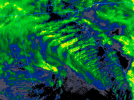
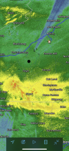
Didn’t we see one of the models depicting something that looked like this?not sure what this wave pattern is called over Georgia...but it sure is pretty
View attachment 106671
snowplow
Member
Snow mixing in now 3 miles S of Chattanooga.
All snow moderate. Temp broken, still 33.6 lol

