Nerman
Member
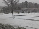
Went to Hiawassee, Ga to see snow and getting all rain while reports come in from Smyrna, Ga of all snow. Ughhh… lol.
It's mindboggling that NE GA is now struggling to get all snow while areas to the southwest are getting snow. Crazy system.
So, you are probably in the same part of the storm we were in around 6am this morning. We shot up 5 degrees but we have since cooled back to 36. We had a warm tongue at 850 keeping our temps up for the longest but that seems to be eroding.....finally.Does anyone know why the temperature is so warm in Hiawassee?
Sent from my iPhone using Tapatalk
Not sure. Forecast is 1-3 inches, higher in higher elevations. The higher elevations will score good,but doubtful about lower.What’s the thinking here for the rest of the day? It’s warming up quite a bit and seems like we have already had the good moisture come through
We have to agree to disagree again. Most of the models showed our best chance of snow on the backend for here and further west into NW GA.All the models had far N GA getting shafted with the backside. That’s the dynamics of this system
 ️
️
We have to agree to disagree again. Most of the models showed our best chance of snow on the backend for here and further west into NW GA.

Sorry I meant NE GA, or basically the people that already scored this AMWe have to agree to disagree again. Most of the models showed our best chance of snow on the backend for here and further west into NW GA.

I’m pretty sure I’m at about an inch of sleet and an inch of snow.Still all sleet here. 27 degrees. Kids outside sledding. 1" of sleet makes the perfect base.