ga_ben
Member
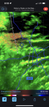
 www.beechmountainresort.com
Is it likely to stay above freezing then and remain rain, or when qpf picks up, will the temps cool again?Got about 3 inches here in Dahlonega. Now just rain as temp is 32.9.
Can confirm getting sleet and rain mixed in right now in West PauldingHopefully getting into a transition here on the Cobb/Pauling line.
Rain here in florence not sure we will even change oversnowing here now SE Huntsville
We back to rain!Looks like a couple pingers mixed in in Woodstock. Crazy that the airport has changed over before we have ??
 Amazing to see ULL in action just south of Birmingham. You can see it rotating through the area.
Hopefully it'll change over for you guys over there soon.Rain here in florence not sure we will even change over
I have lived in Gilmer for five years and a couple of takeaways this storm has taught me. If a progged storm is CAD dependent, forget about it. Eastern Gilmer has too many mountains with some over 4,000 feet that keep CAD working its magic here. We flipped to snow briefly at about 5:30am and the dryslot moved in. Temps soared from about 35 to about 43 in one hour or so. It is just now back to around 39.
The mesoscale models picked this Gilmer County anomaly well by the way. I just thought I would overlook it. LOL. Big mistake.
So for the couple of folks in this area, we do better with clippers than most. Miller A's can be rocking. CAD events suck balls.

 Big flakes here but not sticking on county line in Madison AL


Where are you at in the Triad?20.3/18.1 Larger flakes than earlier. Heavy snow.
I’m hoping that my more northern location keeps me at snow longer. Not expected to get above 28 at the surface. It‘ll all depend on what’s going on above me.
Crazy how being north makes a difference, got 2 inches of front end snow probably gonna end with 3-3.5” of snow/sleet by the time it’s over withSwitched to sleet here after 15mins of Snow at the start. Brutal. Happy for folks in the upstate though, a nice over performer.
I have 30.7 in N Druid Hills...So yeah.Doubt it!
I have 30.7 in N Druid Hills...So yeah.
There is some in the tops .So you must have a lot of ice accumulation everywhere being at that temperature right?

you're about 9 miles to my ESE as a crow flieslooks like close to half an inch where I am at near Huntsville. Roads are turning white and its still coming down strong.
I can honestly say...I NEVER want a storm with this makeup ever again! To completed and complicated! ??