Shadow of the Apps
Member
Rutherfordton- 95% snow 5% IP
7.25” on the ground
24/23 12NNE
7.25” on the ground
24/23 12NNE
What kind of PWS do you have that’s getting that temp? Nearly every reporting station in Dekalb co plus locations to your north are warmer, 33-34.I have 30.7 in N Druid Hills...So yeah.
What kind of PWS do you have that’s getting that temp? Nearly every reporting station in Dekalb co plus locations to your north are warmer, 33-34.


Sleet has taken over here, in Summerfield, NC.

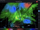
Cold air advection to north and Cold core low to south. Ehhh.View attachment 106644Snow in every direction but the Bham area. Typical for our area.

The NAM has always had trouble identifying the effects of dynamic cooling in these strong FGEN forcing bands… it doesn’t pick up on it until the event is really close in. This is something the HRRR does a great job of picking up on… even when it’s outside of its best rangeFrom what I am reading above it really looks the NAM's sucked balls on predicting where snow would fall...
GSP has 4-5"? CLT has 3"?
View attachment 106639
What kind of PWS do you have that’s getting that temp? Nearly every reporting station in Dekalb co plus locations to your north are warmer, 33-34.