MotoWeatherman
Meteorologist
Got about 3 inches here in Dahlonega. Now just rain as temp is 32.9.
Hang in there. HRRR has been really consistent in wrapping it in between noon and 1pm for your area.Trying hard to be patient as I wait for the backend snow to begin. Really hope I don't get burned here.

4” SpartanburgMy best friend back in Greenville is confirming this to be the best snowstorm since we were kids. I need numbers from the upstate crowd?
Seems rate dependent here as well.Still a mix of snow and sleet. Flakes get large and then let up.
Hang in there. HRRR has been really consistent in wrapping it in between noon and 1pm for your area.
We transitioned to snow about an hour or 2 later than forecasted and now we are primarily sleet/ZR mixConfused as to how you are at 1" and Liberty is at 6". Aren't you close to Liberty ?
This dry slot is real though. And with all the mixing in Mississippi, what’s to keep that from not being an issue here?
Sent from my iPhone using Tapatalk
Around the Clemson area maybe an inch. Haven’t had the chance to go outside yet. Mostly sleet right now I can hear the pellets hitting my I
I'm at 4" of snow+sleet in Southern Greenville county. Unless Clemson has a dome over it, there are higher amounts there.Confused as to how you are at 1" and Liberty is at 6". Aren't you close to Liberty ?
Our temps here are colder. Most spots are in the mid-upper 30s out west towards MS and AL. Just need that cold air behind ULL to filter in and get rid of this warm nose.This dry slot is real though. And with all the mixing in Mississippi, what’s to keep that from not being an issue here?
Sent from my iPhone using Tapatalk
I think the snow is over. Now we need to hope the sleet holds on...Seems rate dependent here as well.
I would say a solid 5 inches off of Augusta road in GreenvilleMy best friend back in Greenville is confirming this to be the best snowstorm since we were kids. I need numbers from the upstate crowd?
Got a friend that lives right by Main Street in Spartanburg saying they got 5.2” so far so definitely an over performer.4” Spartanburg
5-6” Greenville
5-7” Northern Spartanburg co
3-4” Clemson
5-6” Pickens
You and me both. I can here ip pingingTrying hard to be patient as I wait for the backend snow to begin. Really hope I don't get burned here.
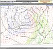
Well the good news is the 850 temps are crashing to our west 0 C line is right on the AL/GA border.More cold air here as a result of the wedge....as soon as 850 drop below zero, we will get snow here....all models have been consistent with that. The problem with parts of AL/MS is that it's not cold enough closer to the surface.
More cold air here as a result of the wedge....as soon as 850 drop below zero, we will get snow here....all models have been consistent with that. The problem with parts of AL/MS is that it's not cold enough closer to the surface.
Just wow at that cold pocket over MOBILE! That should rotate into Georgia as the day goes on. Interested for sure.Well the good news is the 850 temps are crashing to our west 0 C line is right on the AL/GA border.
At 6 am cst, 4.5 at airport GSP, per TWCMy best friend back in Greenville is confirming this to be the best snowstorm since we were kids. I need numbers from the upstate crowd?
Ok so just a question of qpf at this point and the dreaded dry slot.
Sent from my iPhone using Tapatalk
 Snow falling in Clanton, AL about 50 miles south of Birmingham

Looks like a couple pingers mixed in in Woodstock. Crazy that the airport has changed over before we have ??Sleet here by N Druid Hills