NWMSGuy
Member
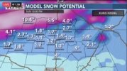
Memphis is mentioning the EURO in their afternoon disco:
Area Forecast Discussion
National Weather Service Memphis TN
343 PM CST Fri Jan 14 2022
.DISCUSSION...
...A Strong Winter Storm to Affect the Mid-South Saturday
Afternoon through Sunday Afternoon...
Ahhh yes, the calm before the storm. A nice and dry day across
the Mid-South at this hour. Temperatures range from the upper 40s
to upper 50s across the region. The latest surface analysis places
a 1003mb low over the Texas Panhandle with a warm front extending
into north central Oklahoma. Aloft, GOES east Water Vapor Imagery
depicts a positively-tilted trough over the Dakotas with an upper
low pressure system off the New England Coast. Another shortwave
trough was analyzed just off the Front Range of the Rockies.
The aforementioned troughs are expected to phase and dive south
over the next 18 hours or so. The trough will quickly cutoff and
deepen as it moves in the ArkLaTex region by tomorrow afternoon.
Ahead of this feature, strong lift and moisture will pool over the
Lower Mississippi Valley. As a result, rain showers will begin
early on Saturday morning and spread north across the rest of the
region through the afternoon hours. Rainfall could be heavy at
times and some thunder is possible, especially over northwest
Mississippi. WPC has outlined a good chunk of the CWA in a
Marginal Risk of Excessive rainfall to account for this. 1 to 2
inches of rainfall is possible with locally higher amounts.
A TROWAL will develop over the Mississippi Delta by late
afternoon, as strong Cyclogenesis occurs beneath the upper low.
In addition, the pressure gradient will tighten significantly by
late afternoon and a wind advisory may become necessary over
northeast Arkansas.
The main event will kickoff around sundown on Saturday. Cold air
will begin to undercut the warm air and convert rain over to
snow across extreme northeast Arkansas and the Missouri Bootheel.
Atmospheric soundings support this quick changeover, although
there may be a couple hours of a rain and snow mix. Model
guidance continues to be less than helpful on location of heavy
snow and snowfall totals. Nevertheless, there is still some time
to fine tune the forecast.
The most consistent model over the past couple of days has been
the ECMWF, which has a significant snow storm along or just south
of the I-40 corridor. This solution remains consistent, but
significantly higher than a lot of the model solutions. The
National Blend of Models is still the preferred approach at this
time. It attempts to weigh all solutions and arrive at the most
reasonable solution. This largely translates to a swath of 2 to 4
inches centered around the I-40 corridor, with slightly less to
the north and south of the area. This seems reasonable given the
high model spread at this time. We still do not have enough
confidence to upgrade the winter storm watch to warnings or
advisories at this point. Will continue with the watch for now.
The final fly in the ointment is the highly dynamic nature of this
system. With significant shear, lift, and moisture in place, a
deformation zone will form somewhere over the Mid-South. This
will be the area of most concern, as snowfall rates could be
extremely high where any bands set up. In fact, some areas could
see upwards of 8 inches of snowfall. I believe that the ECMWF is
broad-brushing the convective nature of this event with its
current solution, but alluding to the area of highest snowfall
accumulation. The CAMs will hopefully latch onto this and lend
some higher confidence to our forecast over the next several runs.
The upper low is expected to lift out pretty quickly on Sunday.
There may even be some good clearing of skies for a few hours.
However, another quick moving shortwave will sneak in behind it
late Sunday night and will likely increase cloud cover once again.
Decided to undercut guidance for high temperatures on Sunday, as
good CAA and cloud cover will be in place.
A couple of quiet and dry days will occur Monday through the
middle of next week, as we remain in dry northwest flow. A cold
front looks to arrive on Wednesday and bring some showers and
maybe a little thunder to the region. Cold air looks to chase the
moisture, so winter weather looks low at this point.
Behind the front, arctic air will build in across the region
through late week as a 1043mb high moves into Mississippi Valley.
Expect below normal temperatures through this period.