Storm5
Member
I meant how reliable is HRRR within roughly 48 hrs or less???
No very. It's good 18 hours in
Sent from my iPhone using Tapatalk
I meant how reliable is HRRR within roughly 48 hrs or less???
Down to airport too! I think this is going to expand further southeast.Well this is different. Hello front end frozen.
Sent from my iPhone using Tapatalk
I was thinking it was very short range. I’ll take the NAM at this point and hope for continued southern slide and later left turn w a hopeful underdone CAD in place!Not very. Does better inside 12 hours
im surprised CAE has no advisories?
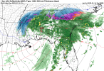
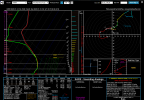
What could go wrong for the North Atlanta burbs lolView attachment 105399
Yeah, I was wondering if Euro and to a some degree NAM might add weight to the possibility.Generally it’s not in its wheelhouse yet, but when it’s matching the Euro so closely it certainly has some validity
Let’s watch what the kicker does hereView attachment 105400
Just a hair weaker and slightly further south than 6z.
I know this has been discussed to some degree previously but how soon will models have a better handle on how the second wave dropping dwn will effect our current system re “where the left turn occurs”? I’m assuming us Ga and maybe Nc/SC folks prefer farther east….The hrrr is south but it's gonna turn corner . It's crap at 48 hours anyway . Two years ago I had 6 inches plus showing from 48 down to 30 hours and ended up with nothing
Sent from my iPhone using Tapatalk
Gulf, how well do you think the modeling is handling the LP at this pt? Eg. Do you buy the more southerly track and also do you buy the N turn thru Ga vs farther east thru Carolina? I’m interested in how the next incoming wave may or may not be effecting the modeling.It's precarious relying on dynamic cooling to get snow especially when you're not under the cold core upper level low....wouldn't put too much into the HRRR for now.
Me too. Didn't your area over perform with a similar finger around valentines day in 2014 or 2015?Watching the little finger of snow in N NC on Saturday afternoon. Might be a nice little teaser for many.
Gulf, how well do you think the modeling is handling the LP at this pt? Eg. Do you buy the more southerly track and also do you buy the N turn thru Ga vs farther east thru Carolina? I’m interested in how the next incoming wave may or may not be effecting the modeling.
I can't keep up with last year's weather, let alone back in 2014/2015..ha! Yes, we've had a few surprises over the years and there are occasionally some out of the blue snows.Me too. Didn't your area over perform with a similar finger around valentines day in 2014 or 2015?
Those dry dewpoints can sometimes dry out more of the storm than you like....and too much warm moist gulf air can sometimes bring more heat than you like...but...the 93 blizzard definitely had plenty of gulf moisture. Not quite the same dynamics here...at least not modelledNAM is a little further south and the High is a little stronger with a bit more CAD at 33.
It's precarious relying on dynamic cooling to get snow especially when you're not under the cold core upper level low....wouldn't put too much into the HRRR for now.


The 12z almost looks like a banana high. I wonder what would happen if that were to set up.View attachment 105403CAD is filtering in a bit more.
It's precarious relying on dynamic cooling to get snow especially when you're not under the cold core upper level low....wouldn't put too much into the HRRR for now.

This is going to continue in future runs...don't ever underestimate a CAD!Definitely up near the cityView attachment 105416

