• Hello, please take a minute to check out our awesome content, contributed by the wonderful members of our community. We hope you'll add your own thoughts and opinions by making a free account!

Wintry Jan 15-16 Winter Storm Discussion & Obs

i'll be shocked if clt metro sees 4-6" tbh. 1-2" of sleet sure but not snow.
View attachment 105109
The thing is… GSP isn’t going to change their forecast based on one run of one model. Right
now based on all the info, I think 4-6” is a reasonable first call for the NW half of the Metro and 2-3” for the SW half
 
By 0z we will be really be getting in 3k NAM range, seems like we've been tracking this forever lol

nam3km_mslp_pcpn_frzn_seus_60.png

Yeah maybe the storm cranks up after that, but that radar looks pretty anemic.
 
I just don't see 12-18 in Marion sleet is going to really hamper those totals if anything I see GSP knocking down those totals wouldn't be the first time. This is a tuff forecast going to have to wait till go time to get an idea of thermals very small adjustments can make or break the foothills. I'd say 3-5 is a safer bet for Burke Caldwell McDowell counties except for elevations above 2500ft with up to an 1in of sleet. Above 2500 I could see a foot along the escarpment.
 

URGENT - WINTER WEATHER MESSAGE
National Weather Service Peachtree City GA
424 PM EST Thu Jan 13 2022

GAZ006>009-014>016-023>025-027-141000-
/O.NEW.KFFC.WS.A.0001.220116T0000Z-220117T0600Z/
Fannin-Gilmer-Union-Towns-Dawson-Lumpkin-White-Hall-Banks-Jackson-
Madison-
Including the cities of Dahlonega, Cleveland, and Gainesville
424 PM EST Thu Jan 13 2022

...WINTER STORM WATCH IN EFFECT FROM SATURDAY EVENING THROUGH
LATE SUNDAY NIGHT...

* WHAT...Heavy mixed precipitation possible. Total snow
accumulations of 2 to 5 inches, with locally higher amounts in
the higher elevations of far northeast Georgia, and ice
accumulations of up to one quarter of an inch possible. Winds
could gust as high as 35 mph.

* WHERE...Portions of north central and northeast Georgia.

* WHEN...From Saturday evening through late Sunday night.

* IMPACTS...Power outages and tree damage are possible due to the
ice. Travel could be very difficult due to snow and ice
accumulation on roads.
 
c6265f49-6b4a-4d7c-b0a2-11b32d318652-jpeg.105104

Be careful guys; this is the "High End" map that has gotten us before. I think this is the 90% confidence map that this will be the highest totals - in other words a 90% chance that totals will be less than this. Somewhere they have other maps that show low end and mid range. We need to check those out.
Here’s the low end! A bit higher than I expected tbh.

7FD1271D-A72E-4D88-8E4E-A586E1781098.jpeg
 
True...but in their own WSW they mention 4-8 in the 85 Corridor

c6265f49-6b4a-4d7c-b0a2-11b32d318652-jpeg.105104

Be careful guys; this is the "High End" map that has gotten us before. I think this is the 90% confidence map that this will be the highest totals - in other words a 90% chance that totals will be less than this. Somewhere they have other maps that show low end and mid range. We need to check those out.
 
True...but in their own WSW they mention 4-8 in the 85 Corridor
I just checked it
6-8” for the NW Piedmont
4-6” for the I-85 corridor
2-3” south of I-85
I’m assuming that these include sleet since it is included in official weather records as snowfall
 
Nashville saying not so fast on some of the model totals.

Area Forecast Discussion
National Weather Service Nashville TN
318 PM CST Thu Jan 13 2022

.DISCUSSION...

UGH! What a hard and challenging forecast.

The upper impulse will continue to move through the area for the
next couple of hours and skies should clear out a bit overnight.
Tomorrow /Friday/ will be dry. Now here comes the challenges! The
models are still all over the place with no consistency to each
other or even to themselves. The NAM low had been moving north to
come in line better with the GFS and EURO but not the 12/18Z runs.
Was hoping there would be some kind of meeting in the middle for
the models...but no luck as of right now. The previous forecast
had the heaviest snow over NW Tennessee and along the TN/KY state
line. Current forecast now has the heaviest snow over the Plateau.
Let/s go with there will be a band of heavier snow somewhere
around I-40 and north. Where...your guess is as good as mine. The
higher amounts look to be in the 4-6" range...not some of the
crazier high end extreme amounts floating around the internet
right now.

Friday night into Saturday expect a really cold rain maybe with a
few flurries mixed in. It will take some time for the boundary
layer to cool down and moisten up. If any snow falls no
accumulations expected. With highs on Saturday in the 40s it will
be raining until possible late afternoon where there could be a
rain/snow mix first starting in the Fentress/Picket county areas
then spreading down the Plateau and west across the KY/TN state
line. That rain snow mix continues southward overnight and changes
to all snow for I-40 northward and the Plateau. The system pulls
out Sunday night and morning lows on Monday will be in the upper
teens to lower 20s. Would expect there will be some travel issues
Sunday night and maybe into Monday.

Highs on Monday in the 30s...so there could be some residual
wintery stuff around. Lows Monday night into Tuesday continued
cold in the 20s...but highs on Tuesday in the 40s so everything
should melt.

There is another short wave Wednesday and Wednesday night. Chance
PoP no really QPF expected at this time.
 
I just checked it
6-8” for the NW Piedmont
4-6” for the I-85 corridor
2-3” south of I-85
I’m assuming that these include sleet since it is included in official weather records as snowfall
What are we considering the 85 corridor? How far north? I’m in Huntersville and I think we will be lucky to get 2” of snow. Sleet seems more likely.
 
maybe we can luck out on some back end snow
The back end snow will end up going over the areas that get hit with the brunt of the storm. So they will basically get all of it. Energy flys to far Northwest of us. If we can't make the main system work, this storm will be a wiff for Central SC. Still 48 hours to go before a firm forecast is set though.
 
c6265f49-6b4a-4d7c-b0a2-11b32d318652-jpeg.105104

Be careful guys; this is the "High End" map that has gotten us before. I think this is the 90% confidence map that this will be the highest totals - in other words a 90% chance that totals will be less than this. Somewhere they have other maps that show low end and mid range. We need to check those out.

Even for the high end map, GSP is going all in! I don’t remember numbers that high.


Sent from my iPhone using Tapatalk
 
What are we considering the 85 corridor? How far north? I’m in Huntersville and I think we will be lucky to get 2” of snow. Sleet seems more likely.
That would be in the 4-6” area of the map which right now seems reasonable. You got to remember when they are putting these accumulations out there, they are for snow and sleet accumulations. Sleet is counted as snowfall in official weather records.

Edit: to add to this there’s always a lot of questioning of GSP’s maps, but often it’s due to them not putting out high enough numbers to match what we read on models. That team does an outstanding job and the have their reasons for their forecast. They will make adjustments as needed.
 
from wxsouth From WxSouth: Latest model data continues to come in, one by one, all dipping further south and east. Colder for all areas north of the storms track. More precip, more ice, more snow in areas I've already outlined. The trend continues for a serious Winter storm across the MidSouth to MidAtlantic.
271884027_10223934251616459_7545835890307078871_n.jpg
 
Nice writeup by Memphis this afternoon:


Area Forecast Discussion
National Weather Service Memphis TN
331 PM CST Thu Jan 13 2022

.DISCUSSION...

Currently...Pleasant day underway across the Mid-South with some
mid clouds moving across area and temps in the 50s and lower 60s.

Tonight and Friday...Weak high pressure will skirt the region with
slightly cooler but dry weather. Lows tonight will be in the 30s
and highs in Friday from the 40s north to 50s south.

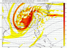
Friday night through Sunday...Two pieces of energy, one from the
Pacific NW and one from southern Canada, will combine over the
plains. This upper low along with its attendant surface low, will
drop due south into the southern plains and then head east across
the Lower Mississippi Valley. Rain will spread into the Friday
night and Saturday. As the upper low tracks into MS Saturday night
and continues to rapidly deepen, expect a well defined
deformation zone/TROWAL to set up somewhere across the Mid-South.
Expect rain to change to snow from NW to SE partially due to CAA
but also due to strong upward motion cooling the warm layers
aloft. Current snowfall forecasts do not do a great job conveying
the potential impacts from this winter storm. Locations that find
themselves with this band N/NW of the upper low will likely see
significant snowfall while areas outside the band may not see

much. The period of time of greatest threat is from around
midnight until mid morning Sunday. During this time the surface
low moves slowly across from east MS into AL. The deformation zone
pivots across the region and wherever that pivot occurs will be
the jackpot area for snow. The 12z guidance has an array of
potential solutions and seems to have shifted somewhat southward.
We will be using along and north of the TN/MS line rather than
I-40 as a reference point for the areas with the best chance of
significant snowfall but keep in mid this area will likely change.
Wind will also be a consideration given the tight gradient. North
winds at 15 to 20 mph gusts on the north side of this system seem
reasonable. A watch was considered but since impacts will likely
start well into the 5th period will hold off this forecast cycle.
Snow will taper off Sunday afternoon.

Sunday night into Tuesday night...Temps will be driven by snow
cover to some extent. For now looks like lows in the 20s Monday
morning though not sure what this following shortwave moving
through on NW flow will do. Could send some cloud cover our way.
Undercut NBM on Monday highs as high pressure builds in and
prevails through Tuesday.

Wednesday and Thursday...Next system may impact the area Wednesday
into Thursday with perhaps some winter weather. Some ingredients
are there but honestly have not focused much on it with the
upcoming winter storm. The active pattern continues.
 
from wxsouth From WxSouth: Latest model data continues to come in, one by one, all dipping further south and east. Colder for all areas north of the storms track. More precip, more ice, more snow in areas I've already outlined. The trend continues for a serious Winter storm across the MidSouth to MidAtlantic.
271884027_10223934251616459_7545835890307078871_n.jpg
Let’s reel this one in for I20 northward to the state line…
 
Don't read too much into where the map algorithm prints the low pressure center, check out the previous hours lol
View attachment 105120
Yep. If you want the back end snow you must pay attention to where the ULL goes.

Edit: The 18z GFS did continue to eek south though.
 

Attachments

  • gfs_z500_vort_seus_fh66_trend.gif
    gfs_z500_vort_seus_fh66_trend.gif
    844.1 KB · Views: 40
Back
Top