NHC officially forecasting a Cat 5 storm
-
Hello, please take a minute to check out our awesome content, contributed by the wonderful members of our community. We hope you'll add your own thoughts and opinions by making a free account!
You are using an out of date browser. It may not display this or other websites correctly.
You should upgrade or use an alternative browser.
You should upgrade or use an alternative browser.
Tropical Hurricane Lee
- Thread starter RBR71
- Start date
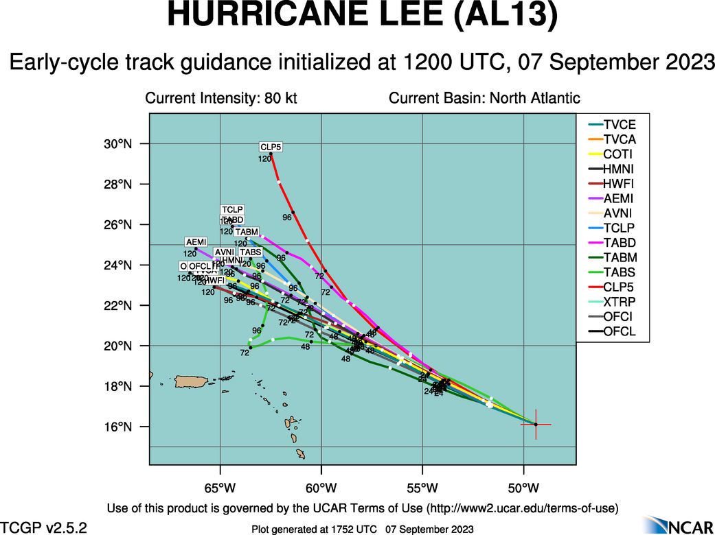
I had not paid much attention to path of the hurricane models until I read them mentioned in the latest NHC discussion, they are all south of most guidance (not that I expect much beyond that to change). Thought it interesting that the 06 runs of the hurricane models had Lee moving almost due west at end of their run (which is only out to 126) so still would curve beyond that
Henry2326
Member
11 am discussion
Good grief....
Many of the models are calling for remarkable rates of intensification, beyond rates normally seen with model forecasts.
Both HAFS models forecast Lee to exceed 150 kt within the next 2 days, and even HCCA brings the hurricane above the category 5 threshold.
The NHC intensity forecast has been shifted significantly higher, but is actually within the guidance envelope. It should be stressed that internal dynamics (eyewall replacement cycles) will become a factor with the maximum strength of Lee as it becomes a major hurricane.
This is almost certain to lead to fluctuations in intensity that are
beyond our ability to forecast at these lead times.
Hurricane Hunteraircraft are scheduled to investigate Lee beginning this evening and overnight, which should provide extremely useful information about Lee's intensity during the coming days.
Tornadocane
Member
NHC has definitely over-estimated Lee's pressure. This ain't a 983Mb storm. It's likely around 966-974Mbs at this point. It looks amazing at this point.
Probably correct that at the 5 PM advisory.
NHC has definitely over-estimated Lee's pressure. This ain't a 983Mb storm. It's likely around 966-974Mbs at this point. It looks amazing at this point.
Caribbean October. 1954 I believe Ms. Hazel. That's the jack in the box imo. Caribbean is at a broil. Need a fancy digging, neg trough to pull it up seaboard.Just like 1995. We may get something yet though from the gulf like we did with Opal that year. The season may very well last longer than usual due to warm water temperatures.


Tornadocane
Member
Probably correct that at the 5 PM advisory.
Yeah. I'm thinking there will be a massive correction by 5PM. Dvorak Data-T estimates of 5.5 at 11:00am. Now up to 6.2 Raw T. This will be a category 4 by the time HH flies into the storm with pressures near 950Mb.
Hurricane Lee Discussion Number 9
NWS National Hurricane Center Miami FL AL132023
1100 AM AST Thu Sep 07 2023
Lee is rapidly intensifying. Early this morning, a well-defined
low-to mid-level eye was observed in microwave imagery, a signal
that is often a precursor rapid intensification (RI). Since then,
Lee has developed an eye in visible and infrared imagery, with
subjective Dvorak Data-T estimates quickly increasing to as high as
5.5 during the past hour or so. Satellite classifications supported
an intensity of around 80 kt at 1200 UTC, but given the significant
improvement in Lee's appearance since then, the advisory intensity
is set at 90 kt.
Henry2326
Member
My most recent memory of the models bombing out and everyone ignoring them was Michael.....and we know how that turned out.
Final T# Adj T# Raw T#
4.6 4.6 6.2
4.6 4.6 6.2
Certainly looking more and more likely OTS but should be a fun one to watch
Shaggy
Member
With the size the Wind field is projected to be its great that its looking like a missCertainly looking more and more likely OTS but should be a fun one to watch
Just looking at the GFS, it’s still showing a 953mb as it’s moving over the southern tip of New Foundland close to St John’s. It would likely have a massive wind field by then.With the size the Wind field is projected to be its great that its looking like a miss
Last edited:
Shaggy
Member
Planes in the air correct for data gathering for model Ingestion?
 www.tropicaltidbits.com
Aircraft Reconnaissance | Tropical Tidbits
Live updating recon data for the Atlantic basin
Euro, oh boy a Maine LF
First recon plane is off and on its way!
AL, 13, 2023090718, , BEST, 0, 166N, 507W, 105, 961, HU,
One issue I can already see from this EURO run is that it initializes the storm way too weak at 993mb. I think we can all look and agree right now that this is likely a major hurricane at this point.
Really hope this stays out to sea. This is going to be a monster. I think we're seeing it becoming more and more the norm for these hurricanes to explode quickly in our current climate. Scary.
packfan98
Moderator
Too close for comfort for New England and Canada.
Big difference on the trough over the GL at Hr 140 ish when comparing the euro/ukmet camp to the gfs. GFS to positive tilt
Tornadocane
Member
Really hope this stays out to sea. This is going to be a monster. I think we're seeing it becoming more and more the norm for these hurricanes to explode quickly in our current climate. Scary.
Agreed. I think we'll probably know by Saturday or Sunday if this truly stays out to sea. Only a few adjustments in the trough could taken Lee horrifyingly close to New England.
Too close for comfort for New England and Canada.
just yesterday he was guaranteeing it was ots ?
Tornadocane
Member
UW - CIMSS
ADVANCED DVORAK TECHNIQUE
ADT-Version 9.1
Tropical Cyclone Intensity Algorithm
----- Current Analysis -----
Date : 07 SEP 2023 Time : 191020 UTC
Lat : 16:39:35 N Lon : 50:53:23 W
CI# /Pressure/ Vmax
5.6 / 957.7mb/104.6kt
Final T# Adj T# Raw T#
5.6 5.8 6.6
Estimated radius of max. wind based on IR : 19 km
Center Temp : +18.4C Cloud Region Temp : -69.7C
Scene Type : EYE
Subtropical Adjustment : OFF
Extratropical Adjustment : OFF
Positioning Method : ARCHER POSITIONING
lexxnchloe
Member
Too close for comfort for New England and Canada.
Yes, the runs with Margot further west push Lee further west
lexxnchloe
Member
Euro 12z today another bit west of last night

last night


last night

Brent
Member
ForsythSnow
Moderator
Forecast now maxes out at 165 mph too this advisory. Have to see if the HAFS is right in 24 hours but I'm not sure a 200 mph storm will happen.Cat 4 and becoming stunning on satellite. Recon will be there in a couple hours View attachment 136900
Heelyes
Member
S
Should be some good surfing on the OBXEuro 12z today another bit west of last night

last night

Brent
Member
Forecast now maxes out at 165 mph too this advisory. Have to see if the HAFS is right in 24 hours but I'm not sure a 200 mph storm will happen.
It's definitely gonna be hard in that area. Irma topped out at 180 in a similar spot. Dorian was 185 in the Bahamas. The others were 185-190 in the Caribbean or the Gulf
Tornadocane
Member
We now have Major Hurricane Lee! Max winds 130MPH.
980
WTNT33 KNHC 072051
TCPAT3
BULLETIN
Hurricane Lee Advisory Number 10
NWS National Hurricane Center Miami FL AL132023
500 PM AST Thu Sep 07 2023
...LEE NOW A CATEGORY 4 HURRICANE...
...RIP CURRENTS AND HAZARDOUS SURF WILL SPREAD ACROSS THE NORTHERN
CARIBBEAN FRIDAY AND BEGIN AFFECTING THE MAINLAND U.S. BY SUNDAY...
SUMMARY OF 500 PM AST...2100 UTC...INFORMATION
----------------------------------------------
LOCATION...16.9N 51.3W
ABOUT 780 MI...1260 KM E OF THE NORTHERN LEEWARD ISLANDS
MAXIMUM SUSTAINED WINDS...130 MPH...215 KM/H
PRESENT MOVEMENT...WNW OR 295 DEGREES AT 15 MPH...24 KM/H
MINIMUM CENTRAL PRESSURE...953 MB...28.15 INCHES
Post-Tropical Cyclone Chantal Public Advisory
www.nhc.noaa.gov
probably still goes ots but emergency management personnel from about Connecticut-eastward have reason to be absolutely terrified; 12 foot surge going up providence bay is a real thing on the table
Brent
Member
probably still goes ots but emergency management personnel from about Connecticut-eastward have reason to be absolutely terrified; 12 foot surge going up providence bay is a real thing on the table
NHC did put this at the end of the discussion
There is uncertainty in any northward turn of Lee beginning early
next week, but it is too soon to speculate about specific potential
impacts a week or more out.
I think it turning north is a given based on modeling right now. The big question is how long will Margot block it from being able to turn east any. The EURO has it blocking off until it’s too late and we see go very close to Cape Cod and then up into Maine.NHC did put this at the end of the discussion
There is uncertainty in any northward turn of Lee beginning early
next week, but it is too soon to speculate about specific potential
impacts a week or more out.


