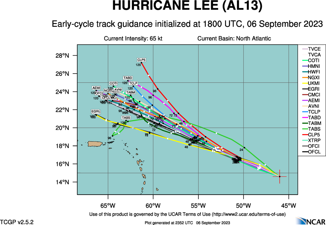
GFS ots but slower, further west and need to watch trend with that trough digging SW.

GFS ots but slower, further west and need to watch trend with that trough digging SW.
View attachment 136874


This is my two cents. Unless a high pressure builds over the top or in the western atlantic to keep it south, it's a fish storm or maybe in the extreme ne. Guess we will see how it ultimately plays out
Not only is the GFS further west with its latest run but further south too. That indicates that a high may be building in north of Lee and that will push Lee more to the south. If a high pressure system sets up shop in New England then the flow will do two things, push Lee further south and keep the trough that is supposed to pick Lee up and escort it out to sea from moving far enough east to prevent landfall somewhere along the East Coast.GFS ots but slower, further west and need to watch trend with that trough digging SW.
View attachment 136874
Decent shift in ensembles againGFS ots but slower, further west and need to watch trend with that trough digging SW.
View attachment 136874
Yeah a few westward stragglers and again NE and SE Canada should really be paying attentionDecent shift in ensembles again

Close to having a member into the GOMYeah a few westward stragglers and again NE and SE Canada should really be paying attention
The trend seems to be a bit more west each runNot only is the GFS further west with its latest run but further south too. That indicates that a high may be building in north of Lee and that will push Lee more to the south. If a high pressure system sets up shop in New England then the flow will do two things, push Lee further south and keep the trough that is supposed to pick Lee up and escort it out to sea from moving far enough east to prevent landfall somewhere along the East Coast.


Weaker systems stay west, which doesn't seem likely at this point but plenty to iron out over the coming daysheres the 12 GEPS
Looks like the Euro will be south a bit so farSeems most modeling is also slowing Lee down, you can add Euro to that as well.... really don't know if that has any effect down the road or not
Yeah but turning north too unless something major changes I think that trough in one form or another will protect the ECLooks like the Euro will be south a bit so far

Either it's on to something or it's the NAM 2.0.
And HAFS-B is just stupid ridiculous
More Nam for sure, it’s been shown to make every hurricane a Cat 100. Something they need to fix.Either it's on to something or it's the NAM 2.0.
The dgex of the hurricane modelsMore Nam for sure, it’s been shown to make every hurricane a Cat 100. Something they need to fix.
That's getting close to the islands with the latest Euro run. If Lee gets any closer that could portend bad things to come for the Leeward and Windward islands along with the Dominican Republic, Hatti, Puerto Rico and Cuba and the Eastern US down the road.
I hate to say it but that is not far at all from a look that would not only cause an EC landfall but pull it inland for a bit. A stronger storm would beef up the ridge to the north.That’s close to boom time. View attachment 136882

I just heard a meteorologist say that the Hurricane Hunters were scheduled to fly a recon flight tomorrow. When they are able to get some real time data, it will be fed into the models and we will get a better picture of where Lee will go. This meteorologist stated that if the storm track didn't change from the current track after the data was fed in that he felt pretty certain that Lee would be headed out to sea.Need a NOAA Recon up NW Canada, few dropsondes and forecast the trough right. More so than Lee itself.
I would think it’s just as important if not more so to get good recon info up stream. Ultimately it’s the timing of the trough and positioning of the ridge that’s going to determine where it goes. It’s fairly strong agreement that it’s going to be a monster of a storm for a time.I just heard a meteorologist say that the Hurricane Hunters were scheduled to fly a recon flight tomorrow. When they are able to get some real time data, it will be fed into the models and we will get a better picture of where Lee will go. This meteorologist stated that if the storm track didn't change from the current track after the data was fed in that he felt pretty certain that Lee would be headed out to sea.
Just looking at that i would say a landfall on Long Island. Will they be close enough to interact?
FIFY..Yeah a few westward stragglers and again NC and SC, maybe even Canada should really be paying attention