Yep you have to disconnect the wave over the NE from the energy from the southern plains and allow the ridge to build back into the mid Atlantic to force it due west or its still ots or hits the NE
-
Hello, please take a minute to check out our awesome content, contributed by the wonderful members of our community. We hope you'll add your own thoughts and opinions by making a free account!
You are using an out of date browser. It may not display this or other websites correctly.
You should upgrade or use an alternative browser.
You should upgrade or use an alternative browser.
Tropical Hurricane Lee
- Thread starter RBR71
- Start date
lexxnchloe
Member
What no one is talking about is the disturbance near the bahamas now. No model develops it and i dont think a surprise storm will pop up but whether it just dissipates or gets a little more organized could be important.

Brent
Member
...TROPICAL STORM LEE EXPECTED TO RAPIDLY INTENSIFY INTO AN
EXTREMELY DANGEROUS HURRICANE BY THE WEEKEND...
EXTREMELY DANGEROUS HURRICANE BY THE WEEKEND...
Yep...it would need a lot of work for a hit, not impossible but not something I am rooting for either. I would rather see some cool weather.Yep you have to disconnect the wave over the NE from the energy from the southern plains and allow the ridge to build back into the mid Atlantic to force it due west or its still ots or hits the NE

Shaggy
Member
That would have to be the camp to watch to see if more members start to join that line of thinking. I like to say we have to get the ball on the court and those further SW members are a step to getting that ball on the courtObviously most of the EPS members are OTS but did notice a small clustering of members that are slowing it down now with less pronounced northward turn (at least a slower turn anyway)
View attachment 136840
Shaggy
Member
Cary_Snow95
Member

Shaggy
Member
Trough over the great lakes looks less amped and more positive tilt as it makes the NW turn slightly west of 12z
Shaggy
Member
Really digs in past hour 138 should be a clean recurve with none of that turn back to the NW
Shaggy
Member
Wind field suggest a prolific wave maker is in store
lexxnchloe
Member
Its going too fast again but lets see what midnight shows. Meanwhile i will post how the gfs may give us Gloria part 2 in the tropical threadReally digs in past hour 138 should be a clean recurve with none of that turn back to the NW
Although all bets are still on the table, it appears Lee will stay offshore for now. No matter how much someone likes chasing storms or exciting weather, the NHS thinks Lee is one storm that any rational person wants no part of.
Shaggy
Member
Definitely a split now on the ensembles
lexxnchloe
Member
If it were to hit land NC north it would be considerably weaker than its peak strengthAlthough all bets are still on the table, it appears Lee will stay offshore for now. No matter how much someone likes chasing storms or exciting weather, the NHS thinks Lee is one storm that any rational person wants no part of.
lexxnchloe
Member
How so?Definitely a split now on the ensembles
Shaggy
Member
12z was clustered offshore recurving. 18 splits into 2 camps with a hot or 2 on the southeast coast later in the run.How so?
Attachments
Shaggy
Member
That's fairly interesting

Shaggy
Member
Starting to see a western cluster similar to the 12z eps?
lexxnchloe
Member
lets see if it is a trendStarting to see a western cluster similar to the 12z eps?
NoSnowATL
Member
NoSnowATL
Member
Hmm
12z eps

18z eps

12z eps
18z eps
Shaggy
Member
That ball is getting closer to the court......just isn't there yet
It's definitely getting the islands back in playThat ball is getting closer to the court......just isn't there yet
Definite shift south on a lot of those.
ForsythSnow
Moderator
If you want to look at clown map look no further than the HAFS model. Feels like a NAM run. Yes, that is 10m winds, not 850.
I was just about to say… this should be at full strength by then and it wouldn’t take much of shift south from those to at least give them a glancing blow. I did notice earlier that Webb isn’t convinced yet this is definitely OTS yet.It's definitely getting the islands back in play
Shaggy
Member
0z already north of 18z early
Brent
Member
Rip Nova Scotia 
If Ryan Maue, whose versed in tropical forecasting/research is saying predominantly a fish storm, then I am confident in it being that.
lexxnchloe
Member
Just when the GFS takes a dump on us the Euro comes more west
tonight

12z yesterday

tonight
12z yesterday
lexxnchloe
Member
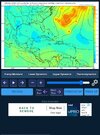
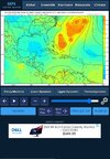
This is interesting. The trof has split with lower pressure over the north gulf coast and building high to the north. I bet if there was a 264 Lee would come more west.

?

Apparently not supported by eps but something to keep an eye on I guess

Apparently not supported by eps but something to keep an eye on I guess
?
View attachment 136865
Apparently not supported by eps but something to keep an eye on I guess
View attachment 136866
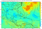
Yep, the Euro is about dead on for running this into the Mid-Atlantic.
Each cycle more and more ensembles cross 70 west at some point. The mean line (Black) is a hard sharp right turn at 68. See if it nudges anymore the next few cycles.
ForsythSnow
Moderator
HMON joined the HAFS at blowing this thing up to a 5 in a few days with the HAFS doubling down and sitting pressure near 900 with long-term cat 5 winds. Either the HAFS is going to be the DGEX of hurricane models now or we're about to see something we haven't seen since Maria and Irma in terms of intensity.

lexxnchloe
Member
06gfs a little more west and it brings gloria part2 alot more west than 0z
Shaggy
Member
So much for JBs quiet period06gfs a little more west and it brings gloria part2 alot more west than 0z