Henry2326
Member
Icon and Nam have it on east coast at noon tomorrow.
EURO IS 6 pm tomorrow.
GFS is between 6 pm and midnight.
Icon and Nam have it on east coast at noon tomorrow.
If its at the coast at noon then they may be on the right pathIcon and Nam have it on east coast at noon tomorrow.
EURO IS 6 pm tomorrow.
GFS is between 6 pm and midnight.
Icon and Nam have it on east coast at noon tomorrow.
EURO IS 6 pm tomorrow.
GFS is between 6 pm and midnight.
Where does it LF?HRRR is around 10am
Sent from my iPhone using Tapatalk
Where does it LF?
Where does it LF?
He's crossing the state pretty fast and is only down to 125, have to question if this will be a hurricane on the other side now because I'm starting to feel it will.
18z euro is slightly farther north
LF was in Hilton Head again. There’s a battle between the NAM/UKIE and pretty much everyone else. Yes you could include the long range HRRR but let’s be for real. That model is WAYYYYY outside it’s useful range. Will be interesting to see the 0Z runsNot far off from CHS, still. Nothing like the far northern outliers
It's moving about 30 or so miles east every run though. Have to wonder just how far north this thing gets. The faster movement gives the trough a better chance to pull it north and east.Not far off from CHS, still. Nothing like the far northern outliers
That’s great news for Florida!
Sent from my iPhone using Tapatalk
It moved 1 county east over our area though. The center goes up highway 321 now, instead of up through the Union and Gaffney area. Still a big rain and wind event for many of us though.LF was in Hilton Head again. There’s a battle between the NAM/UKIE and pretty much everyone else. Yes you could include the long range HRRR but let’s be for real. That model is WAYYYYY outside it’s useful range. Will be interesting to see the 0Z runs
If it LF anywhere from South Georgia to Georgetown we will get a lot of rain and I still think the coverage will be more than what models are showing. There’s a ton a jet dynamics, an extremely tight gradient over a CAD dome, and a stalled front over the region. Only way we get skunked is if the UKIE happens. Which I still stand that the stalled front and jet dynamics is clearly what pulls this to the NW and that 9/10 times you’re going to have a stronger than modeled WAR that just isn’t going to allow these Far East solutions that gets this thing so far north before turning NW.It moved 1 county east over our area though. The center goes up highway 321 now, instead of up through the Union and Gaffney area. Still a big rain and wind event for many of us though.
There is some truth to this. I’ve been watching that particular plot since you mentioned it the other nightTake the TVCN/X (gray lines) and move ahead of it by a click.
That's where it's been ending up consistently.
On this one would be just south of Charleston, which would not be good.
But we have about 48 hours of more clicks to get through.
And to further test the theory, this is the model from Sept 26.
Compare it to where we ended up.
A click ahead of the gray lines.
Not very scientific, but it keeps happening over and over.
View attachment 122464
View attachment 122469
It's about 140 miles across FL on current track, it's traveled roughly 60 miles inland, approximately 80-90 more to go. If it doesn't slow down it will be sniffing salt water around daybreak... we shall see. I mean just 48 hrs ago it was Panhandle to Big bend region, then Tampa and finally way south of there. Also forecast to basically stall at LF. It's followed none of what it was suppose to do, nothing is off the table at this point. And tbh kinda foolish to say otherwise
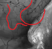
Looks like to me the trough is lagging behind most modeling but I could just be way off haha.. would think this allows more northward movement idk, thoughts?I think its been hit on pretty well here, but the faster the system moves over the next 12-24 hours increases its chances of feeling the effects of the trough which would pull the system further northward over the Atlantic. But at this point, I really don't know which model will have it right going forward.
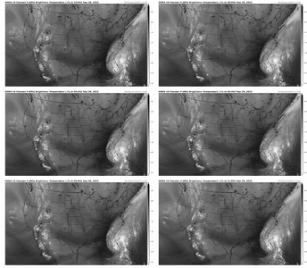
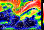
Crude MS paint of where the trough is on this gifLooks like to me the trough is lagging behind most modeling but I could just be way off haha.. would think this allows more northward movement idk, thoughts?
View attachment 122476

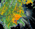
Pretty similar to where it was with its 12z run I think. Eh may be splitting the difference between the 12z and 18z runs00z NAM is a little slower to exit Florida and a little west
I agree with you, I actually think, as others have said here, that Ian might hit the beach overnight. He is crossing halfway through the state already and looks to be moving fairly quickly.I think its been hit on pretty well here, but the faster the system moves over the next 12-24 hours increases its chances of feeling the effects of the trough which would pull the system further northward over the Atlantic. But at this point, I really don't know which model will have it right going forward.
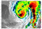
Which means any distance off left to right could mean anything from Charleston to Wilmington.I’d say Myrtle Beach to Calabash this run
Yeah I’d say it’s still a wide cone until we know when this thing leaves FL. If I had to guess though, id still say Bulls Bay, SC.Which means any distance off left to right could mean anything from Charleston to Wilmington.
