lj0109
Member
Yeah that's a very aggressive run and something I would expect from the 3k not the 12k. It really lagged the trough and allowed for more of a weakness and right track. It's probably not right but it's still barely within in the reasonable expectation envelope.
It looks like its moving fast enough to be off the east coast fairly soon
Lol pretty muchDustin riding this thing out in a Toyota Corolla ?. God speed my man. We are all living vicariously through you.
That high in the NE is ridiculously strong!! No wonder models are showing it getting pushed West after Florida and or the AtlanticHWRF doesn't even get it out on the atlantic...so still big spread among models. I hug the EPS mean at this range, hard to beat.
View attachment 122453


That appears to be a tick west of the most recent NAM

Sent from my iPhone using Tapatalk
And this is my wishcast.That appears to be a tick west of the most recent NAM
Yep, reminds me of Charley’s late last minute east shift. Tampa was fortunate both times.Considering this was just yesterday that was a pretty extreme right turn and a headache for forecasters. Not making excuses for those that didn't evacuate but those in that Southern area really didn't have a ton of time to make plans.
View attachment 122458
I wasn’t trying to wish cast and apologize if I’m wrong. Obviously I’ve looked at a lot of models today like all of usAnd this is my wishcast.

If this thing comes in just south of Charleston as a cat 2, it’s really bad news. For their sakes, I hope it goes either north or south but it could be real badConsidering this was just yesterday that was a pretty extreme right turn and a headache for forecasters. Not making excuses for those that didn't evacuate but those in that Southern area really didn't have a ton of time to make plans.
View attachment 122458
So, my area is under a TS watch. Idk when the last time that was.

Bonus:
Has been for days now. Always east of forecast
Can't wait to see if that impacts destination on proposed EC landfall.Has been for days now. Always east of forecast
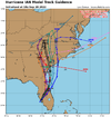
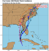
Take the TVCN/X (gray lines) and move ahead of it by a click.Can't wait to see if that impacts destination on proposed EC landfall.


Morgerman was showing the surge coming on in the area. Hope he got elevated.We haven't heard from @DustinWx in a little while. He had to have gone through the violent backside of the eye wall. Hope he's okay.
