• Hello, please take a minute to check out our awesome content, contributed by the wonderful members of our community. We hope you'll add your own thoughts and opinions by making a free account!

Tropical Hurricane Ian

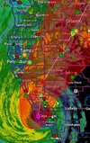
Watch the crawl outside of Tampa Bay.
This is a 48 hour period drilling the coast.
A cat 4 coming to a crawl. Sure it's shredding, but thst energy has to go somewhere.

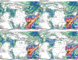
ecmwf_midRH_seus_fh66-111.gif
 
I’ve got a feeling this thing is going to get uncomfortably close to Tampa yo the point that it’ll be in the eyewall for several hours without an actual LF happening before Ian creeps up the coast and makes a true LF in the big bend. A couple things I think worth noting is while there is shear and dry air that has this thing weakening on approach, as ILM stated I wonder if it’s somewhat being overdone to an existent. We’ve seen for probably at least a the last 5 or 6 years that these hurricanes often have been strengthening on approach for a variety of reasons (biggest thing is those 2 words we aren’t allowed to say changing how traditional weather and forecasting used to behave. Also the forward motion of the storm going to the NE I think could actually get a little venting help from the shear and if this thing gets up to CAT 4 strength which I think is almost a given at this point, it’s going to take a while for dry air to even breakdown the eyewall to get into the core. I also am not sold on the front making it as far south as these things tend to stall right off the coast of the Atlantic and just north of the Gulf which would give it additional time to get north without weakening. Will be interesting to see in the coming days.

Side note, it’s finally nice to see that the GFS is catching a hint with the QPF and moisture fetch. All models paint widespread 4-6” of rain for most of our areas now.
 
Major right up to the bay....NHC is all over the TVCN/X track....

5 am
It should again be stressed that there is still significant uncertainty in the trackof Ian, especially in the 3-5 day time frame, and users should not focus on the details of the track forecast at longer time ranges.
(IMO....still not sure if is gonna pop out the east side of FL for an East coast run. See EGRI in spaghetti model....continues to push East).

View attachment 122111


FORECAST POSITIONS AND MAX WINDS

INIT 26/0900Z 18.2N 82.0W 65 KT 75 MPH
12H 26/1800Z 19.7N 83.0W 90 KT 105 MPH
24H 27/0600Z 21.7N 83.9W 105 KT 120 MPH
36H 27/1800Z 23.6N 84.1W 115 KT 130 MPH
48H 28/0600Z 25.3N 84.1W 120 KT 140 MPH
60H 28/1800Z 26.7N 83.7W 115 KT 130 MPH
72H 29/0600Z 27.7N 83.4W 100 KT 115 MPH
96H 30/0600Z 29.2N 83.0W 80 KT 90 MPH
120H 01/0600Z 32.0N 82.9W 35 KT 40 MPH...INLAND

View attachment 122112

View attachment 122113
Yeah that cone is definitely narrowing… I still like a landfall about Cedar Key or just to the south of there. That track from the NHC really is about a worse case scenario for Tampa. A major crawling slowly just to the west is really gonna be piling the water up in the bay even as it weakens
 
I’ve got a feeling this thing is going to get uncomfortably close to Tampa yo the point that it’ll be in the eyewall for several hours without an actual LF happening before Ian creeps up the coast and makes a true LF in the big bend. A couple things I think worth noting is while there is shear and dry air that has this thing weakening on approach, as ILM stated I wonder if it’s somewhat being overdone to an existent. We’ve seen for probably at least a the last 5 or 6 years that these hurricanes often have been strengthening on approach for a variety of reasons (biggest thing is those 2 words we aren’t allowed to say changing how traditional weather and forecasting used to behave. Also the forward motion of the storm going to the NE I think could actually get a little venting help from the shear and if this thing gets up to CAT 4 strength which I think is almost a given at this point, it’s going to take a while for dry air to even breakdown the eyewall to get into the core. I also am not sold on the front making it as far south as these things tend to stall right off the coast of the Atlantic and just north of the Gulf which would give it additional time to get north without weakening. Will be interesting to see in the coming days.

Side note, it’s finally nice to see that the GFS is catching a hint with the QPF and moisture fetch. All models paint widespread 4-6” of rain for most of our areas now.
The models are also starting to show a small severe threat with this too. The CAD erodes a little faster, letting higher dewpoint air come a little farther NW into the upstate
 
The models are also starting to show a small severe threat with this too. The CAD erodes a little faster, letting higher dewpoint air come a little farther NW into the upstate
Doubt is erodes. CAD’s are self reliant as moisture falls over the dome is further locks the CAD into place. This is just globals eroding them too fast again that I’m almost certain you won’t see on the short range models once we get in their range. Wouldn’t be surprised at all to see 40’s on Friday around here
 
Doubt is erodes. CAD’s are self reliant as moisture falls over the dome is further locks the CAD into place. This is just globals eroding them too fast again that I’m almost certain you won’t see on the short range models once we get in their range. Wouldn’t be surprised at all to see 40’s on Friday around here
If we know one the about CAD, it’s always going to hold on longer than modeled. I certainly expect that back your way and into the NC foothills could definitely drop back into the upper 40s during the day on Friday… I expect to be in the low 50s here most of the day. There should be a decent severe threat right along the wedge boundary and just to the south and east of wherever it sets up
 
Taking a look at KGSP, the NBM barely gets the dewpoints to 60 on Saturday... mainly 50s for the entire event duration.

KCAE on the other hand gets up to 64 or so...

Now looking towards @Stormsfury 's way in Charleston, it is around 70 :oops:

Charlotte barely breaks 60.
 
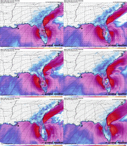
The HWRF paints the best possible scenario to avoid major damage from Ian. It keeps it well west of the Florida peninsula with a ghost of Ian making landfall west of Apalachicola.
 
Taking a look at KGSP, the NBM barely gets the dewpoints to 60 on Saturday... mainly 50s for the entire event duration.

KCAE on the other hand gets up to 64 or so...

Now looking towards @Stormsfury 's way, it is around 70 :oops:
That boundary I bet sets up somewhere within 10 miles either side of an Abbeville, Union, Rock Hill line. The I-85 corridor will most likely stay in the CAD all the way through though.
 
If we know one the about CAD, it’s always going to hold on longer than modeled. I certainly expect that back your way and into the NC foothills could definitely drop back into the upper 40s during the day on Friday… I expect to be in the low 50s here most of the day. There should be a decent severe threat right along the wedge boundary and just to the south and east of wherever it sets up
Always have severe threat with landfalling and post landfall TC now add in that wedge boundary, could see potential serious threat along that
 
Always have severe threat with landfalling and post landfall TC now add in that wedge boundary, could see potential serious threat along that
The Euro at one point has over 400 SBCAPE and a cluster of storms over my area. If it verifies, we may have problems.
 
Always have severe threat with landfalling and post landfall TC now add in that wedge boundary, could see potential serious threat along that
It will interesting to see how the WPC lines up watch boxes on Friday because the area with the best chance of tornadoes might be on the wedge boundary, but that could also be outside the right front quadrant of the storm where most tornadoes occur in a tropical system.
 
Some way too early rainfall amounts for key areas from this mornings NBM:

CLT - 3.16 in
GSP - 3.6 in
ATL - 2.7 in
CHS - 6.89 in
TLH - 5.06 in
SAV - 5.75 in
HKY - 3.92 in
RDU - 4.07 in
MRH - 8.27 in
JAX - 10.83 in
MOB - 0.07 in
TPA - 10.04 in
CAE - 3.97 in
 
Back
Top