pcbjr
Member
or Gainesville & Savannah ... LOL ...Well Clayton; you know ridging isn't always a bad thing. In fact, slightly higher heights can give you a storm while very very low heights will send it to Cuba.

or Gainesville & Savannah ... LOL ...Well Clayton; you know ridging isn't always a bad thing. In fact, slightly higher heights can give you a storm while very very low heights will send it to Cuba.
70 one day, and snowing 6 days later. That's what happened with the last storm. And I think when we have a lot of up and down in winter that's when we get better shots at good storms here in NC. We don't want it warm, but we don't wan't it bitter cold for a long time, either.Also, one critically important element to keep in mind...the coldest air in the Northern Hemisphere is just north of the border. There are a lot of ways to bring that down. It's sooooo much easier to get cold when you don't have to wait for our source region to recharge. It can happen quickly. So, you can be 70 F one day and 48 hours later, you're in the 20s. No reason at all to worry today.
Sure, it's actually , The GFS, CMC, and Euro along with their ensembles after about February 2-4, they aren't really dipping the cold down and keep it hung up. Just ridge for days.
It's headed for a huge cold shot towards the end of the run that's spreading SE from the plains
Sent from my SM-J320VPP using Tapatalk

Never any guarantees with weather, but the upcoming period looks much, much more promising than some of the tremendously butt ugly awful patterns that we've seen the last few winters.Ok, if yall say so.
I am trying to add to the discussion, but I honestly don't see anything that cold or interesting. I keep hearing delayed but not denied, but I just don't want it to be wasted. I mean what happens if you spent all this time discussing freezing February, and it's really not even looking like it'll be freezing or get close to it if we are lucky based on current trends. It's really hard to just ignore the model guidance when they keep screaming ridge, and the GFS has a big cold bias.


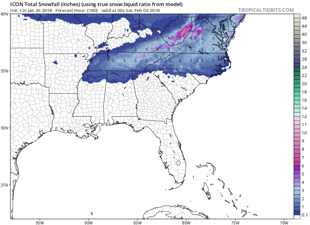
So it's saying 2 inches here for Monday/Tuesday? If so, could be legit since it first popped up less than 5 days out. GFS was showing snow for eastern NC, too.Falls posted this on the other board. ICON: The eastern NC is probably from Monday nightish, but western NC is Fri into Sat.


Everyone seems to want bone chilling cold but our best events come when we're right around 31 32 33 it seems more moisture is able to come up into the southeast
Never any guarantees with weather, but the upcoming period looks much, much more promising than some of the tremendously butt ugly awful patterns that we've seen the last few winters.

Yes, but they have been trending colder by the day...obviously Feb 1,2 won't be as cold as the last end of that period, but it's been showing the trend each day of colder farther southeast.The CPC look over "Normal" is not bad; and it does look good for the Upper South. These Friday maps have human input, correct?

So we are still using 21 year old input? Wow we need an upgrade with this new model unless they fail us and use the old schemes too.Smh, no wonder the GFS is a piece of garbage. We're using outdated microphysics schemes to resolve convection, precipitation, etc.
View attachment 3488


I know what you mean,but why can't we get that in spring and summer instead of it just ruining our chances in winter? I'd be made if severe weather got in the way of winter storms. We get enough of that in the summer.We need a severe winter storm. Wait till then SMH.Irrespective of exactly how strong the SE US ridge is and whether it gets seriously cold in the SE US or not, this pattern in general looks like a ton of fun for whoever gets stuck near the middle. I'd take a look like this every day of the week knowing there could be some severe weather/tornadoes attached to it to chase haha. :weenie::weenie:
View attachment 3491
View attachment 3490
I know what you mean,but why can't we get that in spring and summer instead of it just ruining our chances in winter? I'd be made if severe weather got in the way of winter storms. We get enough of that in the summer. Wait till then SMH.

Lol. There is just as great of a chance of severe as there is winter storms. Stop sweating the details of model runs that will keep changing.I know what you mean,but why can't we get that in spring and summer instead of it just ruining our chances in winter? I'd be made if severe weather got in the way of winter storms. We get enough of that in the summer. Wait till then SMH.
I know what you mean,but why can't we get that in spring and summer instead of it just ruining our chances in winter? I'd be made if severe weather got in the way of winter storms. We get enough of that in the summer.We need a severe winter storm. Wait till then SMH.
Wow ! Fab Feb looks like Flip flop Feb there! OuchIrrespective of exactly how strong the SE US ridge is and whether it gets seriously cold in the SE US or not, this pattern in general looks like a ton of fun for whoever gets stuck near the middle. I'd take a look like this every day of the week knowing there could be some severe weather/tornadoes attached to it to chase haha. :weenie::weenie:
View attachment 3491
View attachment 3490
I beat you toWebber, those images will more than likely stir up some questions from Clayton here soon. Lol.
Eric, I meant I would be mad if severe weather got in the way of winter storms! I'm not talking about the fun of severe thunderstorms. SMH. We get enough severe weather all year round all across the country is what I mean. We don't want that now. There's never any winter storms in late spring/summer in the SE so I don't want to waste these ridiculously warm February's on thunderstorms. We need a cold, stormy February again. Screw this La Nina if it turns warm and we get screwedSummer severe weather here is pretty beign in general w/ airmass, popcorn thunderstorms, the real fun where you can get widespread supercell begins starting around February and this time of the year and goes til about June at the latest.
Wow ! Fab Feb looks like Flip flop Feb there! Ouch
I knew you would post right after I made that comment. Lol. You are getting pretty worked up over this lately. Maybe it's time to take a break for a bit!I beat you to
Well you were talking about the ridge earlier so he is just stating what is showing on the models. If there is a ridge yes there can be severe weather. But it wouldn't surprise me if things changed quite a bit after that. Just have to be patient!This man over here talking about severe weather at a time when it could be cold and snowy when we all know we inevitably get some kind of severe weather in spring and summer! Are you kidding me?!
Yeah could be a few really good gradient type systems with this pattern . At least itsbnot boringIrrespective of exactly how strong the SE US ridge is and whether it gets seriously cold in the SE US or not, this pattern in general looks like a ton of fun for whoever gets stuck near the middle. I'd take a look like this every day of the week knowing there could be some severe weather/tornadoes attached to it to chase haha. :weenie::weenie:
View attachment 3491
View attachment 3490
