Based on the models' forecasts for PNA, AO, and MJO and considering mid Feb (2/10+) climo there, it would not at all shock me if KATL would for the first time since 1884-5 end up with a winter with a third 2"+ snow/sleet.
-
Hello, please take a minute to check out our awesome content, contributed by the wonderful members of our community. We hope you'll add your own thoughts and opinions by making a free account!
You are using an out of date browser. It may not display this or other websites correctly.
You should upgrade or use an alternative browser.
You should upgrade or use an alternative browser.
Pattern Freezing Ferocious February
- Thread starter Snowfan
- Start date
Round Oak Weather
Member
If I remember correctly most of the time it seems to do thatYou are right, but nothing worse than hearing dripping off the roof after it has quit....needs to drop the the low to mid 20s after,,,,....
whatalife
Moderator
I’m sure this belongs in banter and the 18z says game on at hr 372 


Sent from my iPhone using Tapatalk


Sent from my iPhone using Tapatalk
Jon
Member

And keep in mind this is before the PV even gets going south. Feb 5th onward is the timeframe folks.
Sent from my iPhone using Tapatalk
Stormlover
Member
I give up if this happens south of me again, lol

GeorgiaGirl
Member
I’m sure this belongs in banter and the 18z says game on at hr 372
Bahahahaha that's getting close to the time period I've been honking to really clue in on. Game on (*sarcasm*).
JHS
Member
Oh yeah, Feb 1989 was crazy indeed. The first of those storms was a major icestorm down here into SC too. As far that 2nd storm we ended up with around 2-3 inches on the ground, but I imagine up to 6-8 inches actually fell. Warm ground temps melted a lot of it as it fell. Earlier in that month we had temps in the 80's followed by very cold temps for 1 morning. Got down to near 10 here.Yeah there could be a lot of wild swings given the tight gradient in temperature across the contiguous US. Even in February 1989, during what's easily among the strongest La Ninas on record, where we had 2 big storms show up in NC, temperatures soared into the low-mid 80s less than 2 days before a big storm showed up on the 17th & 18th, which was followed by yet another storm several days later.
View attachment 3494
View attachment 3493
JHS
Member
Yep. Most of SC had snow that day. Oddly enough the Augusta GA area got more than most of upstate SC.I wish I was better at poking around weather history, but given that wunderground says that my area had snow on 2/23/89...
GeorgiaGirl
Member
Not that it matters as it will likely be entirely different on the 0z run, but the GFS kind of looks like what we've had some of the old schoolers on this board have said that have sparked up snow. An old frontal boundary eventually moving and becoming something really nice.
That said, 384 hour fantasy land.
That said, 384 hour fantasy land.
B
Brick Tamland
Guest
Why are some so stuck on the warm ups? The back and forth with warm and cold is when we get the best chances for good storms.Wow ! Fab Feb looks like Flip flop Feb there! Ouch
I wish I was better at poking around weather history, but given that wunderground says that my area had snow on 2/23/89...
It did snow in your area, too. I remember the storm fairly well. It started snowing while we were in school (I believe the period before lunch). Several students went to the window, and the flakes got larger and the intensity was increasing.
Shortly afterwards, we received word that school would soon be releasing. By the time, the storm departed; we had 4 1/2-5 inches of snow.
JHS
Member
That storm was weird. If I remember right, Augusta GA and Columbia were both in the upper 20's, while most of upstate SC stood in the mid 30's. One reason I guess that most of our snow melted as it fell.It did snow in your area, too. I remember the storm fairly well. It started snowing while we were in school (I believe the period before lunch). Several students went to the window, and the flakes got larger and the intensity was increasing.
Shortly afterwards, we received word that school would soon be releasing. By the time, the storm departed; we had 4 1/2-5 inches of snow.
tonysc
Member
Yeah that happens sometimes, like in Feb. '73.Yep. Most of SC had snow that day. Oddly enough the Augusta GA area got more than most of upstate SC.
No coincidence my bday is 2/4Raleigh 6"+ SN/IP dates in February
(16 storms): pretty well spread out except a little quiet Feb. 2-5:
2/1, 2/6, 2/6-7, 2/9-10, 2/9-10, 2/10-11, 2/11-13, 2/14, 2/15-6, 2/17-8, 2/18-9, 2/21-2, 2/25-6, 2/26, 2/26-7, 2/28,
Sent from my SM-G955U using Tapatalk
GeorgiaGirl
Member
It did snow in your area, too. I remember the storm fairly well. It started snowing while we were in school (I believe the period before lunch). Several students went to the window, and the flakes got larger and the intensity was increasing.
Shortly afterwards, we received word that school would soon be releasing. By the time, the storm departed; we had 4 1/2-5 inches of snow.
Haha, I asked my dad about this period and he said "I don't remember", of course he's also insisted before that when he moved down south from Ohio (which was shortly after 1973) that he was hearing about a "big snow" that happened in 1974 on the radio.
But yeah, from what I'm reading here apparently KAGS has the same issue too with not being able to record liquid equivalent well. I think this area had 3 1/2-4 inches of snow.
I feel like we've done this same thing quite a bit the last few years big ridge goes up in the Pacific models try to drive the energy into the SW and we get a SE ridge. Then as we step forward in time the trough axis is farther east and the SE ridge is muted an off shore.
Sent from my SM-G955U using Tapatalk
Sent from my SM-G955U using Tapatalk
packfan98
Moderator
Excellent post with historical data for Greensboro, NC. Some great years and some duds. Definitely one of the better spots to be in the SE outside the mountains.
Brent
Member
I give up if this happens south of me again, lol
Story of the winter here lol
 I Love me some DT!! Aleeeeeet
ForsythSnow
Moderator
Which cherry picked ensemble member did he pick to get that lie? Or did he use a multiplier?View attachment 3495 I Love me some DT!! Aleeeeeet
Stormlover
Member
KSDK woudn't be in the east anyway, it's St. Louis, DI said he's not in the mid atlantic region..who said he was?View attachment 3495 I Love me some DT!! Aleeeeeet
https://www.facebook.com/Craig.Moeller.2/
perfectly symbolizing this winter for CHA metro area...Story of the winter here lol
Kylo
Member
I feel like we've done this same thing quite a bit the last few years big ridge goes up in the Pacific models try to drive the energy into the SW and we get a SE ridge. Then as we step forward in time the trough axis is farther east and the SE ridge is muted an off shore.
Sent from my SM-G955U using Tapatalk
By day 12 on the GEFS really is moving the polar vortex low in a good spot with good blocking. Would be nice if the EPS showed this but the GEFS has shown this for a few runs now.

skywatcher
Member
Spann has been hinting at this for a while now.And keep in mind this is before the PV even gets going south. Feb 5th onward is the timeframe folks.
Sent from my iPhone using Tapatalk
SOMETHING TO WATCH: Keep an eye on brutally cold air over Siberia; no threat to North America now, but if a cross polar flow forms in coming weeks, that could spell trouble for Canada and possibly parts of the U.S.
BHS1975
Member
Spann has been hinting at this for a while now.
SOMETHING TO WATCH: Keep an eye on brutally cold air over Siberia; no threat to North America now, but if a cross polar flow forms in coming weeks, that could spell trouble for Canada and possibly parts of the U.S.
Bring it
Sent from my iPhone using Tapatalk
I think he's calling out that guy , not his forecast. He's just a hoot!Which cherry picked ensemble member did he pick to get that lie? Or did he use a multiplier?
pcbjr
Member
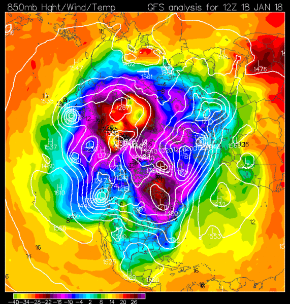
More ingredients for the stew ...
Courtesy Ryan Maue
Courtesy Ryan Maue
February looks really fun. One threat remains around the 2-3rd that we'll have to continue to watch. After that, the 5-15th looks fun with the possibility of repeated threats.
Btw- look who I found on nws chat lol @Brick Tamland
Btw- look who I found on nws chat lol @Brick Tamland
Attachments
Stormlover
Member
Kentucky seems to be the place to be on the first one..but Tennessee may still do great too..0Z GFS for next Thu/Fri Edit: eastern NC gets some right after this,

Last edited:
Storm5
Member
Damn that's a big cokd shot on the 00z gfs
Sent from my SM-J320VPP using Tapatalk
Sent from my SM-J320VPP using Tapatalk
whatalife
Moderator
Damn that's a big cokd shot on the 00z gfs
Sent from my SM-J320VPP using Tapatalk
Yes it is...
Sent from my iPhone using Tapatalk
Kentucky is the sweet spot 00ZGFS

And yet another coastal NC threat. If I see another one of those this winter I'm going to lose my sh**
OBX has like 14"+ this winter already..enough is enough
OBX has like 14"+ this winter already..enough is enough
240hr bullseye. What could go wrong?Kentucky is the sweet spot 00ZGFS
Stormlover
Member

50 in Macon, -34 in Peoria... lol Quite a spread:

olhausen
Member
Yes except the gfs has been plastering the same area run after run for a number of days now. The euro also had the storm a few days ago then lost it and then brought it back today. Still I obviously don’t know how it will truly play out but I can’t remember a time where models kept nailing the same spot run after run over a week out. This thing is now 6 days out and tomorrow will be 5 unless it moves up in time as it did this run. Like I said earlier I’m not getting to excited yet but it’s getting more and more difficult with each run. If this bad boy is still showing totals like this on Sunday it will start to really suck me in.240hr bullseye. What could go wrong?
Stormlover
Member
CMC

Brent
Member
50 in Macon, -34 in Peoria... lol Quite a spread:
the Illinois state record is only -37 lol
Set in the same town as the famous Rochelle tornado a few years ago
Stormlover
Member
question: if the euro only goes to 240 hours..why is there a 15 day high low meteogram available for it? where are the 15 day charts then?