I don’t know if it is necessarily warmer but definitely more moist through 45Nam is going to be juiced again, warm noses for everyone!
-
Hello, please take a minute to check out our awesome content, contributed by the wonderful members of our community. We hope you'll add your own thoughts and opinions by making a free account!
You are using an out of date browser. It may not display this or other websites correctly.
You should upgrade or use an alternative browser.
You should upgrade or use an alternative browser.
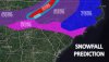
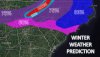
Wintry February 19-21, 2020 Winter Storm
- Thread starter Six Mile Wx
- Start date
Storm5
Member
Another great nam run for tenn and extreme northern ala / ga
Sent from my iPhone using Tapatalk
Sent from my iPhone using Tapatalk
NBAcentel
Member
oh no, sleet soundings everywhere
NAM has IP moving in to south-central NC by 10am Thursday.
Looking at the NAM and I just realized that it has sped up somewhat instead of coming in 21z Thursday it's now around 12z Thursday.
Yep we knew this was coming gets us every time, next time let’s remember to not get excited unless the snow line is in Charleston at day 3.oh no, sleet soundings everywhere
I haven't checked any soundings or maps yet, but if the NAM has a warm nose, then you can almost take that to the bank every time. Wouldn't be surprised to see that start to get established and trend stronger, which sucks.
NBAcentel
Member
yeah, NAM may be on to something, its showing what normally happens, stronger WAA, lots of frontogenesis, warm nose, and faster tongue of overrunning precip that arrives earlier, NAM may be on to something, as those are classic issues with overrunning setups
Storm5
Member
Warning criteria for a large part of Tenn.

Sent from my iPhone using Tapatalk

Sent from my iPhone using Tapatalk
John1122
Member
I'm getting NAM'd into oblivion on the 12z. Looks like a state wide overrunning event for Tennessee now. The 06z Euro returned this way a bit so my hopes are flickering. Refuse to go all in though. Too many nammings for me in the past.
D
Deleted member 1449
Guest
This sounding off the 12Z NAM for Thursday afternoon for the NW Piedmont is a thing of beauty: strong lift into the snow growth zone and below freezing through the column. If true, this produce fairly impressive snowfall rates.

Stormlover
Member
Par for the course. They are often the last to the party.NWS Huntsville is not impressed.
"Although not indicated in the current
grids, a brief period of sleet will be possible for most of the
forecast area at the onset of precipitation, based on thermal
profiles in the 20/09-12Z timeframe. However, as the rate of
hydrometeor production increases aloft, the low-level airmass will
modify to support very cold rain or perhaps a rain/snow mixture for
portions of northwest AL/southern TN."
ouch..warm nose will be present. How fast can it erode? That’s the question 
Six Mile Wx
Member


The NAM sniffed out the last two flizzards it makes a man wonder...I think that HP will limit the coastal from correcting to far NW but it won't matter for Western areas as were getting ours from the overrunning whitch Webb hit the nail on the head precipitation will probably be more exspansive than being advertised and the Nams best at sniffing that out imo...more so than globals the meso picks up on terrain, smaller features that can enhance precipitation and other variables...
Oh and the warm nose is alive and well it's one of those things were we want precipitation to get here before 1pm so It can accumulate I ran into that last month 33 pouring snow but just couldn't stick but at the same time we want the precipitation to hold off a little so the warm nose can erode kinda a double edge sword I think 1-3 statewide is a safe bet at this range...
Oh and the warm nose is alive and well it's one of those things were we want precipitation to get here before 1pm so It can accumulate I ran into that last month 33 pouring snow but just couldn't stick but at the same time we want the precipitation to hold off a little so the warm nose can erode kinda a double edge sword I think 1-3 statewide is a safe bet at this range...
Last edited:
Webberweather53
Meteorologist
yeah, NAM may be on to something, its showing what normally happens, stronger WAA, lots of frontogenesis, warm nose, and faster tongue of overrunning precip that arrives earlier, NAM may be on to something, as those are classic issues with overrunning setups
Yeah I think the NAM is definitely onto something here while the ECMWF is out to lunch
Another great run for NC. By hour 63 almost all of NC has or is experiencing wintery precip (except for OBX).

Downeastnc
Member
NAM another crush job for central eastern NC, we might see a bit of a mix for the first few minutes but the NAM has snow and all snow the duration of the event here.....starts right around hr 52 and snows all the way till hr 70 or so call it 18 hrs of snow.....been awhile since we have had something like this possible here, since Dec 2010 probably.
D
Deleted member 1449
Guest
3K NAM is on board, too, though it appears faster than the 32K.

Fountainguy97
Member
3km looks very similar to 12km at long range. I find usually outside 48 hrs the 3km can be too dry at times.
That is further credit to the 12km solution. We may have something here...
Onset for me here in Eastern TN is in 48 hrs. with virga falling even before that.
That is further credit to the 12km solution. We may have something here...
Onset for me here in Eastern TN is in 48 hrs. with virga falling even before that.
B
Brick Tamland
Guest
Looks like the NAM actually increased totals for NC this run. Euro might be out to lunch.
WXinCanton
Member
Hope you NC folks score!!! On the last event, the NAM didn't get clue until almost the day the before. It and the Euro both were pretty close for MBY. Just food for thought. That said those NAM maps are Awesome, hopefully it's correct, good luck!!
iGRXY
Member
3K does not have quite as stout of a warm nose in the upstate. I think we can crash the column pretty quick with how cold it is at almost all levels and the warm nose might be 33 degrees at most. Even then both the NAM and 3K have 2-4 inches along and north of 85 which I think is smart.
MichaelJ
Member
You can clearly see the difference in what the EURO is depicting compared to the NAM, here is the EURO ar 11:00PM Thursday night and the bottom is the NAM at virtually the same time


B
Brick Tamland
Guest
Wow, and that is with the Kuchera method.

nam has a warm nose from hr 50-60 for clt while much of the precip moves through, and it even gets stronger from hr 54 or so on. this looks to be a sleet storm most likely for charlotte with token flakes on the back end. nam showing a warm nose like this and you can take it to the bank.

John1122
Member

The earlier arrival on the NAM means much better accumulation opportunities. Had been showing up at 1 or 2 pm. now 7-10 am.
Anyone got sleet maps for NAM?
ajr
Member
RDU is the all snow battle line now...
6z

12z

6z
12z
iGRXY
Member
This is my percentages for overall winter weather and snowfall taking place across the board. I included a separate upstate map for overall precip types since we have a few upstate folks that are wondering what to expect around this way. We really need to watch that warm nose. If its not quite as stout then i=I think we can crash the column pretty quickly and get more snow in here. As always i really see along and north of 85 being the sweet spot for our area. I really think from GSO over to the Triad and down I95 towards Fayetteville will do great but those lower areas really need to watch from that warm nose as well.
Attachments
Six Mile Wx
Member
Anyone got sleet maps for NAM?

Nerman
Member
Look at the temps drop in the last 24 hours of NAM runs. If this continues then more areas will be in the game.

Wondering who will be the 1st to issue a Winter Sorm watch for MBY/Triad Wilkesboro or Raleigh NWS.
12z Nam snows for almost 15 hours in Triad down to Asheboro.

12z Nam snows for almost 15 hours in Triad down to Asheboro.
How? I see 1-2 at best for northern Greenville and Spartanburg based on Kuchera3K does not have quite as stout of a warm nose in the upstate. I think we can crash the column pretty quick with how cold it is at almost all levels and the warm nose might be 33 degrees at most. Even then both the NAM and 3K have 2-4 inches along and north of 85 which I think is smart.
it isn't about sfc temps, its the warm nose.Look at the temps drop in the last 24 hours of NAM runs. If this continues then more areas will be in the game.
NCHighCountryWX
Member
- Joined
- Dec 28, 2016
- Messages
- 700
- Reaction score
- 1,921
Soil Temps

ajr
Member
Look at the temps drop in the last 24 hours of NAM runs. If this continues then more areas will be in the game.
View attachment 35196
I think some of the colder temps seen there is more reflective of earlier onset of precipitation
MichaelJ
Member
Here is the 3K as of Friday morningAnyone got sleet maps for NAM?
