• Hello, please take a minute to check out our awesome content, contributed by the wonderful members of our community. We hope you'll add your own thoughts and opinions by making a free account!

Wintry February 19-21, 2020 Winter Storm

nam has a warm nose from hr 50-60 for clt while much of the precip moves through, and it even gets stronger from hr 54 or so on. this looks to be a sleet storm most likely for charlotte with token flakes on the back end. nam showing a warm nose like this and you can take it to the bank.
View attachment 35189
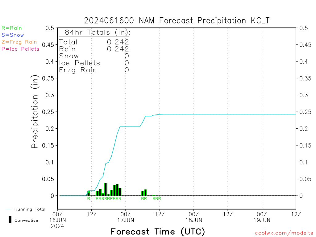
Yea hopefully nam is just over amping this a bit
 
I know its the simulated radar and a bit overdone but I feel like this will be closer to reality because temps will likely end up being colder than expected and I think rates would cool the column pretty quickly after onset. I don't think the rates would be to the extent of this sim. radar but I think they would be pretty close.
60652390.gif
 
I know its the simulated radar and a bit overdone but I feel like this will be closer to reality because temps will likely end up being colder than expected and I think rates would cool the column pretty quickly after onset. I don't think the rates would be to the extent of this sim. radar but I think they would be pretty close.
View attachment 35202
This is absolutely what I see. the warm nose is 33-34 degrees and it is well below freezing above and below that except for the surface. Heavier rates and CAD will collapse the column.
 
mainly pingers for charlotte, not surprised. hope we get some backend flakes.
prec.png
 
This shows the Zero C 850 line set up in NC and parts of upstate SC before the precip moves in. For areas West (GA, AL, MS) it is still arriving about 12 hours too late. That has been the theme for this one.

850s.gif
 
12z ICON ticked a little SE. Good hit for SE NC, I think. Very little precip up towards RDU.

Is this model even any good, BTW? I don't know what its verification scores are.
 
This shows the Zero C 850 line set up in NC and parts of upstate SC before the precip moves in. For areas West (GA, AL, MS) it is still arriving about 12 hours too late. That has been the theme for this one.

View attachment 35203
Yeap need that high and the artic press to move in a little sooner across the SE but walking a thin line of suppression there...truthful wouldn't need to play complete catch-up just 6-8 hours earlier will improve totals across the board
 
NAM 12k has the 700-850 levels significantly colder than the NAM 3k in N AL. Can anyone shed light on which one is more reliable and why at this range?
 
Move this elsewhere if not thread appropriate, but broadly why do you think mets aren't focusing as much on this (and holding onto globals)?

Yes, most tv mets I've seen often go with the globals, especially the Euro and GFS for whatever reason. That's fine when 4+ days out but inside 2-3 days the meso models are usually better, especially with a warm nose. I remember years ago when the NAM was firing warning shots about a warm nose, globals didn't have it and NWS offices were forecasting large snow amounts for RDU to Greenville based on global output. It turned out the 3km NAM had the correct idea and the warm nose pushed all the way to the 85 corridor similar to what it modeled.
 
The ICON ticked south on this run. I definitely think the best chance for snow in general is probably SE of Raleigh even if this ends up way NW in the end
Do you think rates will be too light for Raleigh so that it primarily ends up as a light rain event despite snow falling farther southeast?
 
The NWS has goofed for the last two small events in terms of Ptype. It has snowed with temps in the upper 30s and bottomed out down to 32 both times. I feel like they will miss the boat again. With that said, I don’t know how far the warm nose will make it up i77 but 99% of time it’s as far north as Iredell County NC which is a long county. Maybe the mix will stay near Mooresville but nothing really stopping it if precip rates bounce off and on. It will be a race to 1-3” for many IMO.
 
Probably running out of time for I-20 folks for this one. Probably a sharp gradient in extreme north GA and a nice event for the mountains.


Sent from my iPhone using Tapatalk
 
Next 2 NAM runs will be critical and I think it is possible it will start correcting more towards the EURO. Problem for the SC, Ga, and ENC people will end up being temps and P-Type and for Northern NC and SVa will be moisture. As for the ICON, it has generally been a very poor model
 
Probably running out of time for I-20 folks for this one. Probably a sharp gradient in extreme north GA and a nice event for the mountains.


Sent from my iPhone using Tapatalk

I-20 never had much of a chance . If you want to see snow out of this system you will need to head north


Sent from my iPhone using Tapatalk
 
It's about a lot of things. I think Charlotte will be fine with the rates being shown.

View attachment 35200
One thing that could help out southeast portions of Charlotte metro (SE Mecklenburg and Union Counties) is the development of the coastal low can erode the warm nose quicker as winds aloft turn. Those portions of the metro have gotten in on the developing deform band a number of times with the 2010 Christmas storm being a good example
 
Next 2 NAM runs will be critical and I think it is possible it will start correcting more towards the EURO. Problem for the SC, Ga, and ENC people will end up being temps and P-Type and for Northern NC and SVa will be moistue.

Even though the GFS and Canadian have been trending towards the NAM?
 
Probably running out of time for I-20 folks for this one. Probably a sharp gradient in extreme north GA and a nice event for the mountains.


Sent from my iPhone using Tapatalk
This will certainly be 85 north at this point. That’s just as far as delayed cold can make it with precip streaming through the area. The topography won’t allow it to build any further south until the bulk of precip has moved off to the east. It’s only about 105’ elevation difference between Downtown Greenville and areas in southern Greenville county. But man does it matter
 
Yes, most tv mets I've seen often go with the globals, especially the Euro and GFS for whatever reason. That's fine when 4+ days out but inside 2-3 days the meso models are usually better, especially with a warm nose. I remember years ago when the NAM was firing warning shots about a warm nose, globals didn't have it and NWS offices were forecasting large snow amounts for RDU to Greenville based on global output. It turned out the 3km NAM had the correct idea and the warm nose pushed all the way to the 85 corridor similar to what it modeled.

I remember that with the Jan 6-7, 2017 storm:
Preceding forecast discussion with 5-7 inches (when we ended up getting more like 1-2): https://mesonet.agron.iastate.edu/wx/afos/p.php?pil=AFDRAH&e=201701060342

 
Local mets seem to be totally disregarding any other model and going with the Euro, even though the NAM has stayed consistent, and other models have trended to it.
 
Back
Top