John1122
Member
0z euro looked better than 12z with the snow map I believe
It was a decent bit worse for everyone.


0z euro looked better than 12z with the snow map I believe
If we still have NAM support at 06z than I have high hopes


.png")
.png")

What are your thoughts on the modeling? The NAM keeps cranking out some decent snow for NC yet the EPS has cut back some with a little over 48 hours till verification.


If the euro craps the bed and starts agreeing with other models, NWSs are really gonna start scrambling and upping the threat

NAM doubles down, GFS increased and Euro step back.... hard to go all in without the Euro. Big 12z runs today
Yet seeing the WPC maps, going to be interesting ti see how this unfolds

NAM doubles down, GFS increased and Euro step back.... hard to go all in without the Euro. Big 12z runs today
Yet seeing the WPC maps, going to be interesting ti see how this unfolds
I didn’t see that at all. The NAM was decent and 3K actually had snow breaking out along and north of 85 as precip began rolling through.I have to say over night trends for the upstate was a step back. This is clearly a big hit for Eastern sections of the southeast though more specifically north eastern NC. But areas north of 85 in upstate. We be lucky to see a Dusting to 1.5 inches while high elevations close to sc/nc border gets 2-3 inches. Temps will be a struggle for upstate with .25 Qpf to work with which some falls as rain
Sent from my iPhone using Tapatalk
I didn’t see that at all. The NAM was decent and 3K actually had snow breaking out along and north of 85 as precip began rolling through.
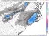
I still think an inch or two is probably the most likely outcome, but it is good to see moisture increasing slightly as we move in. I feel like we're getting scammed by the NAM, though. I mean, I figured we'd get a couple of these big snow maps, but I thought it wouldn't start that until later today or overnight tonight.I generally agree with this 50th percentile forecast for now given how much uncertainty there is atm, maybe an inch or two in favored areas of the south-central coastal plain is a conservatively reasonable outlook for now. This is obviously almost certainly going to change.
View attachment 35164
I didn’t see that at all. The NAM was decent and 3K actually had snow breaking out along and north of 85 as precip began rolling through.

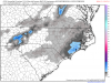
Which is really what the 3K was showing. There’s a warm nose along from Anderson to Laurens to Union SC north that is 32 degrees at around 825 which really isn’t even a warm nose. I’m not really even looking at globals at this point as they have been too reckless at this point and are just now even getting moisture into the areas.This is well before the moisture even arrives. If it verifies I think you've got a very quick changeover to all snow.
View attachment 35167