Lol

Looks like a column crashing band lol
That’s been the story of my 41 years doing this dumb hobbyThese setups can indeed be very tricky, but welcome to the frickin' Southeast lol. If the moisture could roll in during early morning hours with heavy enough rates to crash the column, perhaps we could have predominately sleet. Then again, especially pertaining to the past few years, what I think I know versus what has occurred?? Someone will probably get half a foot of snow??(Disclosure: This is not a forecast.)
I'm also a USC Gamecock and Carolina Panther fan to boot. My hobbies are very humbling and frustrating too.That’s been the story of my 41 years doing this dumb hobby
You too? I’m actually in charlotte to go to a hornets game tonight. We understand pain.I'm also a USC Gamecock and Carolina Panther fan to boot. My hobbies are very humbling and frustrating too.

See yaI can't say how many times; she gone and ain't comin' back.... she leavin' you for a woman... You didn't cut her enough slack....
It is when it's an outlier.A fold is not when a models stops showing it for one run. There will be more runs to determine this


Btw that’s the RGEM, but yeah it’s been really good with H5/precip placement this winter but it has a known cold bias in wedge situations, especially in-situ18z RAP was still going for it View attachment 112877


12z cmc also has stayed consistent with onset ice along with the RGEM everyone says it’s good with CAD around here until it’s on an island .. we will see I guessRGEM continues to be off it's rocker and yet it was so good just a few weeks ago
View attachment 112899
Yep. Better chance of pingers toward the "climatologically favored areas of the NW piedmont."And of course the famous words... “Wintry mix north and west of the Triangle” are being echoed across the local weather reports. “North and west... North and west”.
Sent from my iPad using Tapatalk
12z cmc also has stayed consistent with onset ice along with the RGEM everyone says it’s good with CAD around here until it’s on an island .. we will see I guess

I think your map lines up with where I think the wwa will be - at least for NC.
I think that’s too bullish IMO. It’s likely going to follow climo which would mean that it would likely setup like this, with less in the mountains.

Wet bulb temperatures on soundings all along the shaded areas on my map when precip is moving in is at and below 32, it’s not really bullish having a small T-0.05 And considering areas tonight further north have radiational cooling including the triad before clouds move in, also there’s a stout dry layer in the foothills and mountains limiting precipitation further west.I think that’s too bullish IMO. It’s likely going to follow climo which would mean that it would likely setup like this, with less in the mountains.
View attachment 112927
 my map even goes with GSPs thought
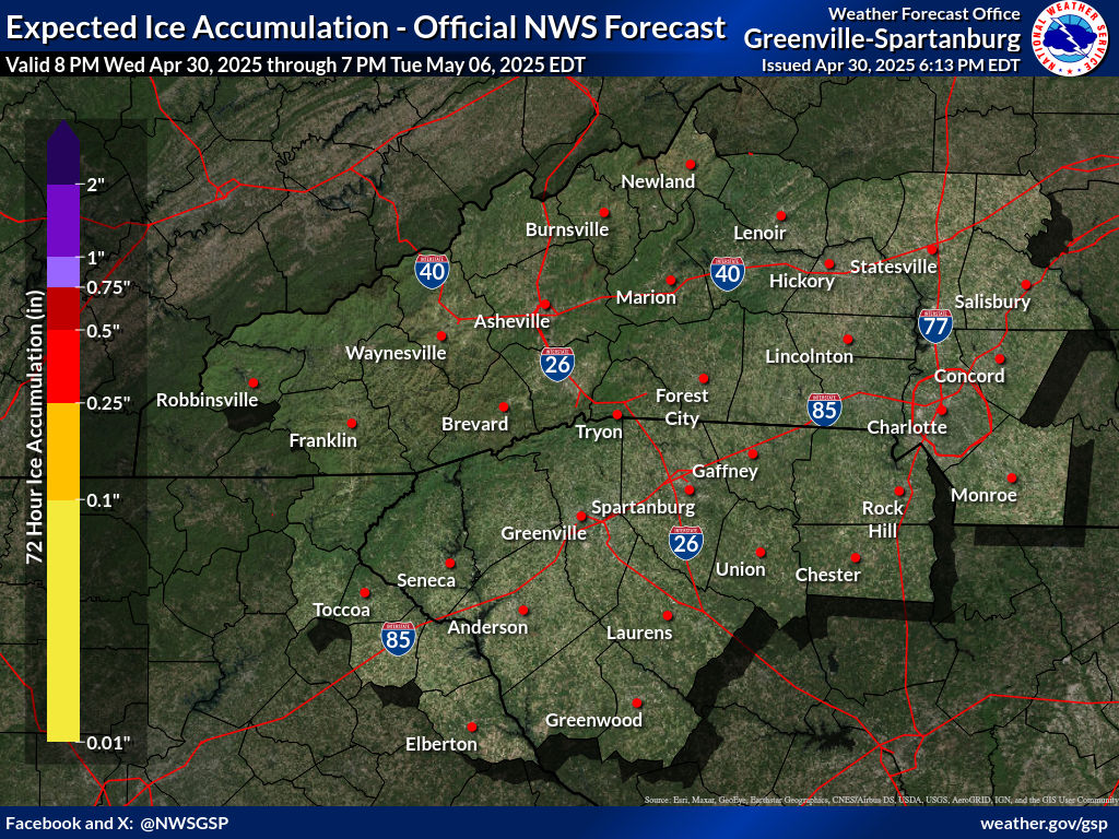
RAH will update tommorow morning.GSP updated ice forecast. Throws some glazing along north CLT and 85 N and E.
RAH's map hasn't been updated since early AM (shows no amounts yet).
Maybe I'm just a little salty, but I can't think of a time when I've been following models where ZR accumulation was more than expected; it always verified to the NW fringing me. I could be wrong, but that's my opinion from personal experience.Wet bulb temperatures on soundings all along the shaded areas on my map when precip is moving in is at and below 32, it’s not really bullish having a small T-0.05 And considering areas tonight further north have radiational cooling including the triad before clouds move in, also there’s a stout dry layer in the foothills and mountains limiting precipitation further west. View attachment 112928 my map even goes with GSPs thought
Im in the heart of cad even if the qpf was more on the models I still wouldn't worry these things hardly ever materialize in this type setup this thing died a long time ago ensembles never supported it.Theres just no support among the models except maybe rgem maybe elevated surfaces see a very very light glaze u have to rub ur fingers on to feel.Maybe I'm just a little salty, but I can't think of a time when I've been following models where ZR accumulation was more than expected; it always verified to the NW fringing me. I could be wrong, but that's my opinion from personal experience.
Out ur way and to the NE along 85 is the best location to see a glaze I think ur map is spot on.Wet bulb temperatures on soundings all along the shaded areas on my map when precip is moving in is at and below 32, it’s not really bullish having a small T-0.05 And considering areas tonight further north have radiational cooling including the triad before clouds move in, also there’s a stout dry layer in the foothills and mountains limiting precipitation further west. View attachment 112928 my map even goes with GSPs thought
