rburrel2
Member
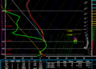
The RHEM is always too cold in these type of marginal set ups. The NAM has the best thermals in these kinds of set ups IMOThis event really sneaking up on us .. one thing I have noticed is dews really are pretty cold .. this has sneaky potential .. I trust RGEM out of anyone but the fact that all the short range guidance is aware of some sort of winter mix is interesting
RGEM did amazing with our thermal profiles the past few events I personally like an RGEM and HRRR combo at the momentThe RHEM is always too cold in these type of marginal set ups. The NAM has the best thermals in these kinds of set ups IMO
I agree it has done very well. But the events this year weren’t marginal. This one was. Last year the RGEM was way too cold with all the marginal events. We ended with 33-34 rains.RGEM did amazing with our thermal profiles the past few events I personally like an RGEM and HRRR combo at the moment
I'd be shocked if this were more than an I-85 northward climatologically favored Ice event from the similarities I've seen in past events. I've posted earlier that we usually bust with ice in two ways:I agree it has done very well. But the events this year weren’t marginal. This one was. Last year the RGEM was way too cold with all the marginal events. We ended with 33-34 rains.
No

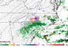
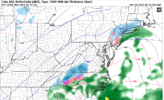
Everyone knows the wedge builds in from the East
Yup, the 850s are too warm and there's not even any WAA.Model soundings depict a stout dry layer in the mid-levels including the DGZ (For the Triad). Unless that changes, don't count on snowflakes.


Guys the NAM is only warmer at the surface b/c it doesn't have much precip. It would wetbulb in the upper 20's like the rgem if it started showing a solid precip shield.
Prob, because it's the NAM and it sucks at predicting the weather? lol.Yes, but why does it not have much precip?
If this doesn’t show how cold biased the RGEM is, I don’t know what would. Don’t just focus on your area. Look at how much colder it is in VA, TN, etc. Also, Jackson, MS, for example, where it has 16 vs 30 for the other models. It has Birmingham at 23 vs low 30s on others. Washington, DC, at 12 vs 20s others.
RAH's early AM afd hinted that h8 flow was more westerly on NAM, which kept it dry. Other models had more flow coming from S and SE.Yes, but why does it not have much precip?


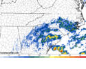
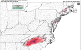
Yep this is what I was talking about earlier .. sometimes these type of light events like to spread precip over us quicker but only time will tel .. the earlier the more of an issue it could beIt’s worth noting the HRRR/RAP brings in precip earlier, in the morning, which is why there’s ZR in the first place, GFS brings it in around noon


| February 16, 2015 | 1 inch of sleet 1/10th inch of ice | 27 | huge bust in our favor, hi-res models at 31/32 for low temp and freezing rain to rain day before event, got 90% sleet and just a little freezing rain, wetbulbed to around 27 and temp was still 31 as final band came through |
That ended up being a largely sleet event here when the forecast was for .3-.5” of ice accrual. If I remember correctly, there was a small mesohigh that formed over VA that helped keep lower dews locked inI'll say this too.... in the past, when models have busted badly being too warm in the short range it's typically related to not modeling dew points/wetbulbing accurately and as a result wetbulbing is way under modeled. This happened in 2015 with an in-situ wedge event.
This could be the same kind of sneaky set up where models are showing a lot of 32-33 degree light rain but people under consistent precip wind up wetbulbing down to 28-29 instead. The dewpoint depressions being shown Monday morning certainly support that possibility. Here are my notes for the 2015 storm.
February 16, 2015 1 inch of sleet 1/10th inch of ice 27 huge bust in our favor, hi-res models at 31/32 for low temp and freezing rain to rain day before event, got 90% sleet and just a little freezing rain, wetbulbed to around 27 and temp was still 31 as final band came through