31/18 NADA
Sent from my iPhone using Tapatalk
Sent from my iPhone using Tapatalk
Lots of school delays and cancellations, but Guilford and Forsyth seem to be on a normal schedule.Hit 2 different Bridges on the way in that where slick/freezing up. The big high ones when you get off 85 to hit the 73/74 junction up to 40 are prime for accidents here soon. Limbs glazing up nice up here GSO
Those bridges off 85 are so high, first to always ice up. Suprised at guilford.Lots of school delays and cancellations, but Guilford and Forsyth seem to be on a normal schedule.


I’m gonna bump this! The Seems to be a lot of wrecks going on , for a ‘non-event’ NES dripped the ball as I’m sure the local Mets did as well?These are the kind of events that cause total chaos and trouble among everyday people. Hardly a mention on news, borderline temps and qpf. It hits 33/34 and drizzle is a tad bit heavi, everybody sees the 33/34 and drive like normal crazies and the bridges ice up and cause all kinds of wrecks.

DOT was warned no excuse for not being preparedLots of accident reports coming in. Terrible timing for this on a Monday morning. Come on sun!
Look at this guy getting some twitter fame this morning ??


Lake Lanier blowtorch. It’s real
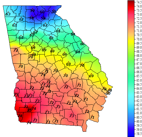
Someone more familiar with that area can probably chime in but it looks in vis that the area in the NW has more radiational cooling due to clear skies longer last night/this morning and the warm tongue is the edge of cloud cover that held temps up. It didn't cool as much as to the east b/c the CAD wasn't strong enough to force cold dry air further w/nw. Also probably has something to do with being at base of Apps but I may be completely off on that
Can anyone explain WTF this warm tongue is?
Near wet bulb east with light drizzle. Clear skies NW.