Jessy89
Member
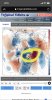
All 3 global ensembles. EPS isn’t as cold obviously. Let’s see who wins.
View attachment 32341View attachment 32340View attachment 32339
That’s a cold enough look to be happy about.
Sent from my iPhone using Tapatalk
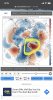
All 3 global ensembles. EPS isn’t as cold obviously. Let’s see who wins.
View attachment 32341View attachment 32340View attachment 32339
I'll take the EPS. And again just because there is blue over the se doesn't mean it's a great pattern for snow. The PV looks strong still with a raging +AO. NAO is neutral at best. Ridging is kind of flat on the west coast and weak. This is not a debbie downer post. Its simply what the model shows. If I'm wrong please feel free to tell me why.All 3 global ensembles. EPS isn’t as cold obviously. Let’s see who wins.
View attachment 32341View attachment 32340View attachment 32339
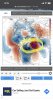
All 3 global ensembles. EPS isn’t as cold obviously. Let’s see who wins.
View attachment 32341View attachment 32340View attachment 32339

I wonder which one I'll pick.
One thing I'll point out is that the 2 meter anomalies of the EPS don't average BN unlike the BN 500 mb anomalies of the EPS.


All 3 global ensembles. EPS isn’t as cold obviously. Let’s see who wins.
View attachment 32341View attachment 32340View attachment 32339
It’s February absent any true arctic air.TWC and Accu doubling down on warm solutions...50’s and 60’s indefinitely
Sent from my iPhone using Tapatalk
It’s February absent any true arctic air.
This may be one of those cases where we just don’t know the final verdict until the precip, if any, is falling from the sky.

GFS juuuust missed something special around the 6th/7th..We can’t afford to miss on this one..this is it View attachment 32361
 ️
️ 


I imagine they were prepared for it! ?NC mountains take a major hit for this weekend’s snow chances..
18z
View attachment 32369
00z
View attachment 32370
Ukie delivered the goods though ??I imagine they were prepared for it! ?


Wow the -NAO has been absolutely going insane the past couple model cycles ... truly a beauty in the beast with this one ... maybe it’s cause I haven’t seen one like that in a while ... would provide us a good shot for some blocking and some good storm tracks later ... wow this pattern holds lots of possibilities


4 hoursOh boy... only 10 days out, let's see how long it takes for us to screw this one up.
View attachment 32376View attachment 32377
4 hours
Really those of us in the east need the low track 100 miles further east and on a more ENE heading otherwise mixing will be a big issue....


What has happened around the RMM phase 3/4 area? The RMMs show the COD, but that looks like phase 3 - 4, with not as much convection elsewhere

Honestly, I can't detect any serious -NAO on any of the modeling. Where are you seeing this?

FWIW: JB was on board this morning for a Snowstorm this weekend from Western Carolinas to the NE!
FWIW: JB was on board this morning for a Snowstorm this weekend from Western Carolinas to the NE!
Understandable but we haven’t seen any -NAO all year and especially not at a favorable time .. we will have it set up during a time where we can actually pull off a big time storm like the Gfs was showing .. all we need is oneI get it but the truth is the NAO is bouncing around between near neutral to slightly negative. There’s nothing there that is really fantastic or that would give any hint of delivering sustained cold and or offer sustained blocking. At least that’s the way I see it. I hope I’m wrong though and that we do get a really strong -NAO.

a 41 degree rainstorm to bring in fab feb, nice!
View attachment 32388