BHS1975
Member
Gfs is like 0-8 right now.Next weekend needs to be watch in the gulf. Some of the 12z gefs members shows storm in central gulf.
Gfs is like 0-8 right now.Next weekend needs to be watch in the gulf. Some of the 12z gefs members shows storm in central gulf.
June 28th 2023I've reached the point this season where I'll believe there's an Atlantic hurricane when it's on satellite ?
We still have September.


Should get some drought relief from that.It's already inland but it sure made an effort. If it had another day probably would have been a hurricane. Maybe a sign things are getting more favorable? Well seeView attachment 120682
The weather nerd in me says if the gfs has been this horrible at showing fake fantasy storms it could be just as bad as picking up initialization and we get a short term surprise that it has missed.Oh I'm sure there will be storms at some point I'm just saying I'm done believing model fantasies ?
The weather nerd in me says if the gfs has been this horrible at showing fake fantasy storms it could be just as bad as picking up initialization and we get a short term surprise that it has missed.
And just like that the 0z is back to producing a cane in the long range.Oh for sure. I mean look at the Gulf thing it wasn't hyped up on the models and very nearly became a thing(wouldn't surprise me in postseason if they declare it)
And tbh things closer to home are much more likely to become a problem anyway. It's a lot harder to get an African wave all the way across to the position(yeah they happen but there's a lot more that don't bother anyone)


Yeah not to be unexpected moving into the heart of the season. Gfs remaining persistent in its long range depictions of the MDR heating upIt's like the models know it's mid AugustView attachment 120703
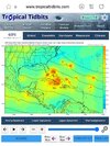
This is an interesting little guy. If it can maintain its vorticity on its east side it'll be in the BOC in about 72 hours and potentially a STx threat. It's moisture and high pwat plume may actually be directed into the SE next week

On the opYou got me excited so i went to look and the hurricane is further east at 06Z than it was at 0Z
For comparison this 384 hrs on 0z and 6z. Far more activity far closer to the east coast and gom between them. This is still 384hrs but just goes to show how different the ensemble was.from the op.You got me excited so i went to look and the hurricane is further east at 06Z than it was at 0Z
Kind of just like winter! ???

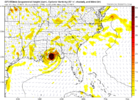
Unless something changes, gonna be major dry air issues as it approaches the mainland unless something changes. Could be really good for rain making though.View attachment 120759
This is the one to watch a homegrown. This is about 3 or 4 runs in a row now.
It's there but slower and weaker so farIs the big cane gone?
Unless something changes, gonna be major dry air issues as it approaches the mainland unless something changes. Could be really good for rain making though.
Has about 10% support from the eps which isn't bad. The evolution of it kicking out of a larger gyre is always problematic and in wouldn't get too locked into anything until about 5 days from today once what kicks out of resolvedView attachment 120759
This is the one to watch a homegrown. This is about 3 or 4 runs in a row now.
Well if it’s dry air than it still has a 961mb at landfallUnless something changes, gonna be major dry air issues as it approaches the mainland unless something changes. Could be really good for rain making though.
I agreeHas about 10% support from the eps which isn't bad. The evolution of it kicking out of a larger gyre is always problematic and in wouldn't get too locked into anything until about 5 days from today once what kicks out of resolved
Yeah the cmc has it but it's west and has a ton of land interaction. We've seen this setup go both ways recently. Laura is a good example of a stronger eastern vort that avoided land interaction and made a US landfallI agree