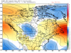
Some parts of North Carolina and extreme norther. South Carolina increase also.How about further east
-
Hello, please take a minute to check out our awesome content, contributed by the wonderful members of our community. We hope you'll add your own thoughts and opinions by making a free account!
You are using an out of date browser. It may not display this or other websites correctly.
You should upgrade or use an alternative browser.
You should upgrade or use an alternative browser.
Wintry 1/26-1/28 Winter Storm Potential
- Thread starter deltadog03
- Start date
EPS 0Z New: BIG INCREASE!!!

Old 12Z Sunday:

Old 12Z Sunday:
Clem282340
Member
What does the members look like
whatalife
Moderator
What does the members look like


Sent from my iPhone using Tapatalk
LovingGulfLows
Member
- Joined
- Jan 5, 2017
- Messages
- 1,499
- Reaction score
- 4,100
Wow... Some really nice members in that emsemble suite. A lot of the "big dogs" seem to focus the axis of heavier snows from Northern Alabma and arcing through N GA, Upstate SC, and the Western half NC.
Arjen Robben
Member
Snow into AL at hr 72 but then dissapates afterwards as it enters GA on 6z gfs.
accu35
Member
6z gfs may get interesting for the weekend storm
0 Precip through Monday 28th, not even that cold6z gfs may get interesting for the weekend storm
It tried on Tuesday, but rains in E NC, SC! Just one run, bout not a good run at all! 0 snow for AL,GA
B
Brick Tamland
Guest
FV3 is remaining consistent and leading the way again. Euro is starting to follow now. GFS will be the last on board, if it ever does get on board. GEFS still looking good.
BHS1975
Member
Navgem had a decent low track.
Sent from my iPhone using Tapatalk
Sent from my iPhone using Tapatalk
Forevertothee
Member
GSP discussion
.LONG TERM /THURSDAY NIGHT THROUGH SUNDAY/...
As of 130 AM EST Monday: Starting at 00Z Friday with the 500mb
pattern showing a broad trough from the Rockies to the East Coast
with a series of clipper type systems moving SE from NW Canada
toward our region. Weak high pressure will keep us dry for
Thursday night then the first clipper system arrives Friday morning.
The current run of the EC has a brief shot of snow only affecting
the northern NC mountains around 12Z Friday. The EC has this feature
lifting out quickly. The GFS has a more robust front reaching the
length of the TN and NC border in mid day Friday with some spill
over east for late day Friday across the foothills and piedmont.
Some light NW Flow snow lingers along the TN border into early
Friday night on the GFS. Medium range models have cold high pressure
passing over our area Friday night into Saturday. The next shortwave
and front increases moisture Saturday night into Sunday with a low
forming near the Gulf coast then moving across Florida. The GFS
fades out the frontal moisture as it crosses the mountains in mid
day Sunday keeping us dry through Sunday night. The EC has a much
more robust low pressure crossing northern Florida Sunday and moving
up the Carolina coast Sunday night dropping a few inches of snow on
the Piedmont Sunday night. Obviously, with varying solutions as to
what may happen next weekend we cannot place any great certainty on
any one scenario. Temperatures will be 5 to 10 degrees below normal
Friday through Sunday.
Not sure why GSP is not considering FV3??
Sent from my iPhone using Tapatalk
Forevertothee
Member

Sent from my iPhone using Tapatalk
They go conservative, until it’s a slam dunk! They do mention the Euro, all local TV mets are going dry on Sat/Sun as of this morningGSP discussion
.LONG TERM /THURSDAY NIGHT THROUGH SUNDAY/...
As of 130 AM EST Monday: Starting at 00Z Friday with the 500mb
pattern showing a broad trough from the Rockies to the East Coast
with a series of clipper type systems moving SE from NW Canada
toward our region. Weak high pressure will keep us dry for
Thursday night then the first clipper system arrives Friday morning.
The current run of the EC has a brief shot of snow only affecting
the northern NC mountains around 12Z Friday. The EC has this feature
lifting out quickly. The GFS has a more robust front reaching the
length of the TN and NC border in mid day Friday with some spill
over east for late day Friday across the foothills and piedmont.
Some light NW Flow snow lingers along the TN border into early
Friday night on the GFS. Medium range models have cold high pressure
passing over our area Friday night into Saturday. The next shortwave
and front increases moisture Saturday night into Sunday with a low
forming near the Gulf coast then moving across Florida. The GFS
fades out the frontal moisture as it crosses the mountains in mid
day Sunday keeping us dry through Sunday night. The EC has a much
more robust low pressure crossing northern Florida Sunday and moving
up the Carolina coast Sunday night dropping a few inches of snow on
the Piedmont Sunday night. Obviously, with varying solutions as to
what may happen next weekend we cannot place any great certainty on
any one scenario. Temperatures will be 5 to 10 degrees below normal
Friday through Sunday.
Not sure why GSP is not considering FV3??
Sent from my iPhone using TapatalkView attachment 12279
BHS1975
Member
Fv3 is locked on clack clack. Hard to ignore the euro though. I hope the 6z is locked too.
Sent from my iPhone using Tapatalk
Sent from my iPhone using Tapatalk
accu35
Member
Thats 0z run
BHS1975
Member
6z much weaker

Sent from my iPhone using Tapatalk

Sent from my iPhone using Tapatalk
Forevertothee
Member
6z much weaker
Sent from my iPhone using Tapatalk
FV3 consistent. Gfs not so much.
Sent from my iPhone using Tapatalk
GFSv3 and GFS in lockstep now! 6z GFSv3!! Ugggghh
Fountainguy97
Member
My two cents this morning.
The fv3 has repeatedly nailed storms this winter 6-7 days out.
This storm is approaching that timeframe today and most of the “setup” for this storm is well inside that timeframe.
The fv3 has been very consistent at the 5H level the past 5 runs. Of course it has moved but no real trends.

When the fv3 locks on like this it typically doesn’t move much after.
It has nailed 3 storms this winter at this timeframe.
I would watch it closely today and into tomorrow.
The chance of a Miller A storm track is rapidlyincreasing and you could argue that a Miller A is likely with the fv3 locking in as it is.
So I think we look to see models lock in a Miller A today. Then tomorrow we can MAYBE start looking at details.
The fv3 has repeatedly nailed storms this winter 6-7 days out.
This storm is approaching that timeframe today and most of the “setup” for this storm is well inside that timeframe.
The fv3 has been very consistent at the 5H level the past 5 runs. Of course it has moved but no real trends.
When the fv3 locks on like this it typically doesn’t move much after.
It has nailed 3 storms this winter at this timeframe.
I would watch it closely today and into tomorrow.
The chance of a Miller A storm track is rapidlyincreasing and you could argue that a Miller A is likely with the fv3 locking in as it is.
So I think we look to see models lock in a Miller A today. Then tomorrow we can MAYBE start looking at details.
BHS1975
Member
My two cents this morning.
The fv3 has repeatedly nailed storms this winter 6-7 days out.
This storm is approaching that timeframe today and most of the “setup” for this storm is well inside that timeframe.
The fv3 has been very consistent at the 5H level the past 5 runs. Of course it has moved but no real trends.
View attachment 12284
When the fv3 locks on like this it typically doesn’t move much after.
It has nailed 3 storms this winter at this timeframe.
I would watch it closely today and into tomorrow.
The chance of a Miller A storm track is rapidlyincreasing and you could argue that a Miller A is likely with the fv3 locking in as it is.
So I think we look to see models lock in a Miller A today. Then tomorrow we can MAYBE start looking at details.
How did the euro do with those same storms?
Sent from my iPhone using Tapatalk
Showmeyourtds
Member
06z FV3 LP tracks still looks great- The timing does seem to be off with the northern stream. Plenty of time to resolve that.
Storm5
Member
I will never be able to unsee the 00z eps run

Sent from my iPhone using Tapatalk

Sent from my iPhone using Tapatalk
Kylo
Member
Upper low that stout and that far south

Jon
Member
My two cents this morning.
The fv3 has repeatedly nailed storms this winter 6-7 days out.
This storm is approaching that timeframe today and most of the “setup” for this storm is well inside that timeframe.
The fv3 has been very consistent at the 5H level the past 5 runs. Of course it has moved but no real trends.
View attachment 12284
When the fv3 locks on like this it typically doesn’t move much after.
It has nailed 3 storms this winter at this timeframe.
I would watch it closely today and into tomorrow.
The chance of a Miller A storm track is rapidlyincreasing and you could argue that a Miller A is likely with the fv3 locking in as it is.
So I think we look to see models lock in a Miller A today. Then tomorrow we can MAYBE start looking at details.
I think the euro will improve come 12z...as you noted above, FV3 has been consistent and Euro is just now finding the shortwave. The last two runs of the euro is a trend toward the FV3 and I expect the EPS to improve as well.

Sent from my iPhone using Tapatalk
Fountainguy97
Member
How did the euro do with those same storms?
Sent from my iPhone using Tapatalk
It found the storm about a day behind when the fv3 did. Fv3 found each storm and locked in in the 144-168hr period. We will be getting the storm into that range tomorrow so for me that’s key.
packfan98
Moderator
I checked a few of the major cities and there is a strong signal. I'll post a few here for folks to enjoy.I will never be able to unsee the 00z eps run
Sent from my iPhone using Tapatalk


I "think" this is where we want to see the models right now with the European suite getting stronger and a suppressed GFS suite with a pretty consistent FV3. Anyway, let's see where it goes over the next 2 days and hopefully many folks in the SE can score with it. It's the best shot we've had as a whole.
I have a hard time believing that for now. Just too much dynamics in play here. Perfect track even for me. Noise for now, we have a legit storm to track. I argue that’s heavy wet snow and isothermal temps, but way to early for that yet.
Yeah, I don't buy that increase in surface temps at all. Surface temps increasing despite dropping heights, strong northern winds and heavy precip? Not happening.
Fountainguy97
Member
I think the euro will improve come 12z...as you noted above, FV3 has been consistent and Euro is just now finding the shortwave. The last two runs of the euro is a trend toward the FV3 and I expect the EPS to improve as well.

Sent from my iPhone using Tapatalk
Agreed. Anything could happen BUT we want the fv3 on our side in this timeframe. Right now we do.
Here is an example of what I am talking about when I mention the fv3 lock in period.
I pushed the consistency on the fv3 as far as you can and got this gif of the past 5 runs.

It’s not perfect obviously BUT the timing and trough is all what I would consider very similar. The energy itself jumps around but that’s just how it is. If you go back to the 120hr page and do this 5 run trend it’s very similar.
Now look at this gif just 48 hrs later.

Look at how wild the 5 runs are. Remember at the 168-144 hr all of the veryb same runs where very similar.
So the “onset” of our system is getting into the 144-168 fv3 “lock in” period. As it does I expect to see some fairly consistent solutions and a few solutions will probably be very very close to reality.
The fv3 this winter has been king at being the first to lock in on a solution. It is the model you want on our side.
Bottom line is we have to wait about 24-48 hrs before the storm is really getting into the fv3 144-168 range.
Well if that happens as modeled tonight congrats AL for sure. Would be a miserable rain at those temps here. Lol. All in all great sign to see for sure.
I think the part that scares me is the transfer. That would stink beyond all imagination to be in the shaft zone.
Upper low that stout and that far south
View attachment 12285
But, the northern s/w is scary. Southern systems tend to trend slows and northern waves speed up. Gotta watch that for sure.
Storm5
Member
the part that scares me the most is your daughter throwing your phone in the toilet again and you disappearing for daysI think the part that scares me is the transfer. That would stink beyond all imagination to be in the shaft zone.
the part that scares me the most is your daughter throwing your phone in the toilet again and you disappearing for days
Maybe I'll just lurk and not post.
who believes that?
Chattownsnow
Member
EPS trend for the past 3 runs.

You can see the high is trending to hold on longer around Newfoundland and our Low closer to the coast and stronger. I said before I was worried about our short wave shearing out and becoming weaker as we moved towards this period but only the regular GFS is showing any real signs of that being a possibility so it looks as though I may be wrong there. Still time to totally lose this thing as ensembles show no storm at all as a possibility still but that looks to have become less likely.
You can see the high is trending to hold on longer around Newfoundland and our Low closer to the coast and stronger. I said before I was worried about our short wave shearing out and becoming weaker as we moved towards this period but only the regular GFS is showing any real signs of that being a possibility so it looks as though I may be wrong there. Still time to totally lose this thing as ensembles show no storm at all as a possibility still but that looks to have become less likely.
Attachments
Jessy89
Member
Just woke up so basically the models this morning. To far south and not cold enough. And we are depending on it trending colder and a NW trend correct?
Sent from my iPhone using Tapatalk
Sent from my iPhone using Tapatalk
Just woke up so basically the models this morning. To far south and not cold enough. And we are depending on it trending colder and a NW trend correct?
Sent from my iPhone using Tapatalk
My friend, you would be better reading more and posting less. I was able to catch up on everything by going back several pages and reading. Don't be lazy.
Kylo
Member
EPS trend for the past 3 runs.View attachment 12294View attachment 12294View attachment 12296
You can see the high is trending to hold on longer around Newfoundland and our Low closer to the coast and stronger. I said before I was worried about our short wave shearing out and becoming weaker as we moved towards this period but only the regular GFS is showing any real signs of that being a possibility so it looks as though I may be wrong there. Still time to totally lose this thing as ensembles show no storm at all as a possibility still but that looks to have become less likely.
Yep, the Newfoundland ridge is flexing and the PV lobe is trending further west. Good for AL/GA/TN but bad for central/eastern NC/SC.

Round Oak Weather
Member
This would force more cold air into GA correct?Yep, the Newfoundland ridge is flexing and the PV lobe is trending further west. Good for AL/GA/TN but bad for central/eastern NC/SC.
View attachment 12297
Kylo
Member
This would force more cold air into GA correct?
The storm track would be further west.

NBAcentel
Member
Clearly already a nw trend for a much stronger low, not good if you live in the Carolinas 