Yeah cold front already through here with winds out of the N and temp down to 43We've already got a rn/sn mPing east of Mt Airy
-
Hello, please take a minute to check out our awesome content, contributed by the wonderful members of our community. We hope you'll add your own thoughts and opinions by making a free account!
You are using an out of date browser. It may not display this or other websites correctly.
You should upgrade or use an alternative browser.
You should upgrade or use an alternative browser.
Wintry 1/20 - 1/23 Winter Storm
- Thread starter packfan98
- Start date
It doesn't. I don't think anyone is tossing the baby out with the Euro's bath water. But it's still a higher quality model than most others, and it doesn't do poorly close to events just because it's a global model. You'll find that most NWS offices use it up to the event taking place. I'm certainly not cancelling the event because of one run of the Euro. The point I was making is that it would have been better if it would have trended in the same direction with the rest of the models with its depiction of precipitation. It may mean nothing in the end, but that would have been better.It's a single operational run of a global model less than 30 hours out. It's like yesterday when the 18z NAM went out to sea and people were cancelling the event.
Forecasting is not using 1 model. It is looking at multiple models over a span of days and objectively seeking consistencies and formulating a guess. 1 Euro op run doesnt change the big picture of this event at all.
I don't understand the pessimism for some here. First off, this is an Eastern NC storm and IF you are lucky enough to see something to the West, that's a win.
h500 looks better across virtually all modeling. The precipitation field is expanding overall across all guidance.. forcing looks better, 700mb, etc. This is 24+ or so hours away on the back end for the Western areas (after 7am tomorrow) if you were to even get it...
Surface maps aren't gospel and me thinks the radar and nowcasts will show that .......
Pingers west of Winston. HRRR gonna score tonight? modernweenie
Downeastnc
Member
The HRRR going a little ham with this arctic front.....

SouthGarnerSleet
Member
Sitting at .25qpf fallen here in Wake County. HRRR forecasted .1 on the previous 6 runs
I mean if the HRRR has a wheelhouse this is it, it has not wavered on the anafront precip and actually is doubling down. Seeing those early mPING reports are very promising as well
NBAcentel
Member
The hrrr might surprise some this run considering this is the difference from 12z to 18z 

lexxnchloe
Member
That alone is almost worth a winter storm warning.
Sleet west of Mooresville? Huh. Not sure about that mPing
D
Deleted member 609
Guest
More interaction between sw right?The hrrr might surprise some this run considering this is the difference from 12z to 18z View attachment 108798View attachment 108799
It’s right ended as wintry mix east of the mtns due to dry air rushing in aloftSleet west of Mooresville? Huh. Not sure about that mPing
DadOfJax
Member
The HRRR has been atrocious with the last 2 events for us here in AL....not sure on verification elsewhere.
packfan98
Moderator
Snowing in Stokes county just north of Greensboro. @metwannabe it's coming for you!
iGRXY
Member

As Fro said above. There is a lot stronger vorticity with that piece coming down from behind. More good trends at H5.
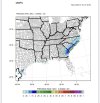
 15z MMFS -
 Freezing rain zone slightly expanded in southern area
Snow accums look about the same
Winter impacts still heaviest in NC, likely due to lower ground temps there.
I’ll fire up the 18z run as soon as that data is available.


Attachments
Temp drop has begun at RDU. 45/43
iGRXY
Member


Lol this is looking wayyyyyyyy better.
lexxnchloe
Member
I think we are headed for a bust on the upside for many tonight.Temp drop has begun at RDU. 45/43
Rain seems to be overperforming today, no? Not sure if that really has any bearing for tomorrow, but interesting to note. Hopefully, the skies won’t need to heal. modernweenie
NBAcentel
Member
Where’s the sfc response on the hrrr lol maybe I’m impatient and it’s coming
brendan123
Member
39/38 here with rain, HRRR had us initializing at 40 at 2pm falling to 39 by 3pm (so on track). Most models along with local mets/NWS calling for around an inch (maybe higher) with the front tonight with 4”-6” for the second event Friday. Maybe a little too high, but we’ll see. Biggest possibility for major snowfall since Jan 2018 here.
iGRXY
Member

This might go boom shortly.
Surface on HRRR at least for tomorrow looks worse but that's strange. Tonights stuff has picked up though
iGRXY
Member
Surface just isn't reflective for some reason.
Whatever’s happening tonight just reeks of something models whiff on, frontogenesis magic
NBAcentel
Member
Hrrr starting to show some sort of band developing in the foothills now
Downeastnc
Member
Where’s the sfc response on the hrrr lol maybe I’m impatient and it’s coming
yeah its confusing......trust in the fact that NW side precip is ALWAYS underdone on over running setups......and if we keep typing that enough it will come true.
NBAcentel
Member
Looks like it’s tryingyeah its confusing......trust in the fact that NW side precip is ALWAYS underdone on over running setups......and if we keep typing that enough it will come true.
There it goes. As of 00z Sat HRRR is more robust but keeping snow east of Wake, about the same as the last run just more QPF so far
Yeah it’s very confusing to say the least… you look at the H5 and it’s following all other trends of the day and continues to improve, but it and the Euro their just isn’t the surface reflection to match that. I’d hate to have to try and put a forecast package together with thatSurface just isn't reflective for some reason.
Downeastnc
Member
Looks like it’s trying
That little band out west is actually new wasa not there are 12Z
brendan123
Member

Precip breaks out actually a little more than last run, just a little delayed
NBAcentel
Member
It’s really trying 

NBAcentel
Member
Hrrr is a tick away from the rgem tbh
Downeastnc
Member
Those little bands out in the piedmont the first warning shots of a change or just a tease.....

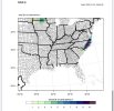
Can you pull up any soundings… I’m away from my computer and can’t… all I can think of is that the moisture just isn’t deep enoughIt’s really trying View attachment 108816View attachment 108817
L
Logan Is An Idiot 02
Guest
Hrrr is a tick away from the rgem tbh
I think that precip near clt will be a lot more than that. It’s trying to pick up on the NW part of the storm imo
Sent from my iPhone using Tapatalk
Whatever’s happening tonight just reeks of something models whiff on, frontogenesis magic
The surface map infatuation is getting to me here.... I literally just loaded bufkit's overview (the actual crappy Windows 95 type program) for my back yard way in CAE and even on the NAM the upper levels aren't far off.. and that's the "drier" NAM way back here..
A band all the way back in GA too!Those little bands out in the piedmont the first warning shots of a change or just a tease.....
View attachment 108819