P12 is a supercell of snow.
-
Hello, please take a minute to check out our awesome content, contributed by the wonderful members of our community. We hope you'll add your own thoughts and opinions by making a free account!
You are using an out of date browser. It may not display this or other websites correctly.
You should upgrade or use an alternative browser.
You should upgrade or use an alternative browser.
Pattern February 2024
- Thread starter SD
- Start date
LukeBarrette
im north of 90% of people on here so yeah
Meteorology Student
Member
2024 Supporter
2017-2023 Supporter
Too early to start drooling, give me that look in 5 days and I will benah, you were right. Very few suppressed solutions. The Mid Atlantic crew have to be drooling. I'm not too unhappy with where we are sitting though.
Just looking at the maps and I get the feeling that Hampton Roads/Extreme NE North Carolina (KECG) are going to be watching everyone else get in on the fun if this occurs.
Yeah that's a storm and big if it happens. Is this a miller-b? Anybody?998 on a mean. Sheeeesh
NBAcentel
Member
Surprisingly the 18Z EPS/control continues to trend better and is starting to look different (look at the NE US/SE Canada)
The more Arctic origin stuff you dig into SE Canada, the colder the setup would Likely be, clearly can see on the EPS/control that true northern stream is digging more

The more Arctic origin stuff you dig into SE Canada, the colder the setup would Likely be, clearly can see on the EPS/control that true northern stream is digging more
Tonight's WPC 500mb forecast at Day 7 is in lock step with the 12z Euro Ens Mean with respect to the placement of the confluence zone running thru North Carolina. Where will we go from here??

TNweathergurl62
Member
I hope you peeps get an amazing Snow! We had 7+ days of snow in during the middle and snow the week before last! 8;inches of snow that seemed like it would not go away! We Loved it but were getting a bit run down with it. Many good wishes for a great snow for you all! 
NBAcentel
Member

- Joined
- Jan 23, 2021
- Messages
- 4,603
- Reaction score
- 15,199
- Location
- Lebanon Township, Durham County NC
Icon was about to be big
CNCsnwfan1210
Member
Yeah I think we would have seen some fireworks in a few more framesIcon was about to be big
Sent from my SM-A136U1 using Tapatalk
Blue_Ridge_Escarpment
Member
It sure was, strong SW with CAD pressing down hard. If you start seeing icon showing a cooler surface you better pay attention.Icon was about to be big
Heights over the NE and our southern stream wave are both south compared to last run on the GFS. Looking like squash city.

It had the surface below freezing down to rdu and pushing Southwest. Heavy dbz's inbound from deep south. The next to last frame had a transfer to gulf coast 990's, then on frame 180 consolidate inland Mississippi.It sure was, strong SW with CAD pressing down hard. If you start seeing icon showing a cooler surface you better pay attention.
Anyway Whos got the Korean model?


Attachments
Looks good to me.

6 hours earlier.

6 hours earlier.
Blue_Ridge_Escarpment
Member
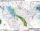
Snow breaking out in NC hour 174 on GFS
Yeah this run it has some light snow there as the back door cold front drops south, but the storm is way suppressed, which, I'm fine with that at Day 7 on the GFS given other guidanceSnow breaking out in NC hour 174 on GFS

It has the exact opposite problem. It has too little of a 50/50 low, which causes the wave to shear out into the ridge and cut.CMC still looks awful
GFS is tracking this thing across South Florida during a strong El Nino...that's led to positive outcomes in the past (Feb 12, 2010)

Up to now, this is unfolding pretty much textbook like the days of yore with GFS suppressed at this range. GFS keeps the southern wave a little more strung out and less consolidated, but has a good push from the northern vortex and good high pressure up top, which are positive trends if they continue.Yeah this run it has some light snow there as the back door cold front drops south, but the storm is way suppressed, which, I'm fine with that at Day 7 on the GFS given other guidance
View attachment 143730
Why wpc trashed it in discussion. It will come around in a few daysCMC still looks awful
rburrel2
Member
Going off the 18z GFS ensembles, suppression is the least of my concerns. Happy to see the 00z GFS stay far south for now.
Nothing about this mean makes me think, "man, I'm concerned there won't be a storm".

Nothing about this mean makes me think, "man, I'm concerned there won't be a storm".
And then watch it slowly start moving north next week.Going off the 18z GFS ensembles, suppression is the least of my concerns. Happy to see the 00z GFS stay far south for now.
Last edited:
Amen x 1000. That back door front is priority #1 and the confluence trending better and holding serve the next 7 days tracking is the key. Without it, we have no white colored qpfGoing off the 18z GFS ensembles, suppression is the least of my concerns. Happy to see the 00z GFS stay far south for now.
Nothing about this mean makes me think, "man, I'm concerned there won't be a storm".
View attachment 143734
GFS right in between what we need…the northern upper low either needs to lift out quicker or dig back further west. It’s sticking right where we don’t want it…except it’s 7-8 days away so actually not bad spot to be in.
That omega block is legit though.

That omega block is legit though.
This one has potential for N and NE Ga.Is this system showing anything for the I-20 area or is this a more north type of deal?
All we can say at this point is that we are tracking the potential for a winter storm across the mid-south, southeast, and southern mid-atlantic for next weekend. All outcomes are possible from no winter storm at all to a winter storm in any and all of those regions, including I-20Is this system showing anything for the I-20 area or is this a more north type of deal?
Lord have mercy


accu35
Member

This has big potential for MS/AL
00z GEFS following same trend of the op 00z GFS - would expect it to end colder and more south than 18z.

0z ukmet only goes to 144. Very similar to gfs, gefs

00z GEFS following same trend of the op 00z GFS - would expect it to end colder and more south than 18z.
View attachment 143743

accu35
Member
Runs not done, but there are a few big members for AL
GEFS comparison to 18z run

I really like the trend we’re seeing for the lower dewpoints across the northeast. That was IMO the biggest thing that was lacking the last couple days… now it’s showing single digit dewpoints down to the VA/NC line which is seen in the stronger CAD events
NBAcentel
Member
GEFS looks great 
accu35
Member

This could be big for lot of people on this board. I’m hyped up
NBAcentel
Member
Thing I like to see this gefs run Vs the last is a more suppressive nature, the gefs run last run had some big members, but also some mid Atlantic members, I’d prefer the spread to be from hits around here to suppression