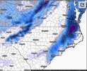
978mb surface low off Charleston. Imagine if you found a way to connect w/ this one.
View attachment 143640
KMA gives us that...?
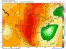
978mb surface low off Charleston. Imagine if you found a way to connect w/ this one.
View attachment 143640

March 2nd, 1980...Reminds me of this one grandma/grandpa storm that had a piece of northern stream dumped into the southern wave and it unloaded in NC, can’t remember when that one happened though, it was a mega winter storm, I think it happened in March of something I’m not sure
Like I mentioned before, KMA can have similar output to Euro so this isn't totally surprising to see solutions within the same ballpark. Obviously those fine details make all the difference.
Reminds me of this one grandma/grandpa storm that had a piece of northern stream dumped into the southern wave and it unloaded in NC, can’t remember when that one happened though, it was a mega winter storm, I think it happened in March of something I’m not sure
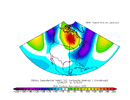
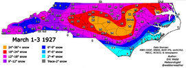
March 1-2, 1980… I believe the only time the entire state of NC got at least 3” from the same stormReminds me of this one grandma/grandpa storm that had a piece of northern stream dumped into the southern wave and it unloaded in NC, can’t remember when that one happened though, it was a mega winter storm, I think it happened in March of something I’m not sure
Yup, that’s exactly it, I think you had a rolling animation of how it went a couple years ago, but southern stream wave progressing east, then a peice of northern stream dove from the NE and phased with the system and it unloadedYeah, there was some great grandaddy storm that likely had a big Hudson Bay ridge that trapped a clipper system underneath, which phased with a southern stream wave and triggered explosive cyclogenesis off the SE US Coast.
Doesn't ring a bell.
View attachment 143651
?Oh boy ? looks like I’m getting a bottle of Hennessy tonight View attachment 143654
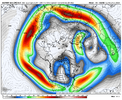
That omega block is starting to get close to the benchmark for big NC winter storms (ridge axis in central/western Canada , with that trend sliding back towards central Canada
Yep. Several members south of mby. Several hits. Several empties. It's a good spread.At this time range, you really couldn't ask for much better of a look from the EPS.
View attachment 143662
View attachment 143663
Lot of options on the table it seems.At this time range, you really couldn't ask for much better of a look from the EPS.
View attachment 143662
View attachment 143663
Someone posted that vort gif/map years ago and I haven’t been able to find it since. It was the biggest nuke you’ll ever seeYeah, there was some great grandaddy storm that likely had a big Hudson Bay ridge that trapped a clipper system underneath, which phased with a southern stream wave and triggered explosive cyclogenesis off the SE US Coast.
Doesn't ring a bell.
View attachment 143651
It’s nice seeing some hits to I-20 similar to the GEFS.Gotta like when the 850 line has trended to Columbia SC Vs a day ago when it was around DC View attachment 143667View attachment 143665
Some absolute bombs on the EPS as well View attachment 143666
Someone posted that vort gif/map years ago and I haven’t been able to find it since. It was the biggest nuke you’ll ever see
Mem32 outlines the state of NC lolAt this time range, you really couldn't ask for much better of a look from the EPS.
View attachment 143662
View attachment 143663
Geesh, those wait ups for the 0z euro?It’s nice seeing some hits to I-20 similar to the GEFS.
Man we have a wild week ahead.
Looks like Met gets a dusting out of thatEuro through Monday at midnight. @metwannabe make sure you send me some pics View attachment 143671
FWIW, JB is starting to talking some and specifically mentioned the CarolinasDT is honking the horn, some strong wording in the tweetx.com
x.com
