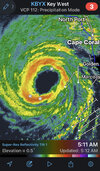
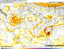
EYEWALL IS JUST ABOUT CLEAR PER WATER VAPOR SAT. IF THAT HAPPENS I SEE 150MPH
-
Hello, please take a minute to check out our awesome content, contributed by the wonderful members of our community. We hope you'll add your own thoughts and opinions by making a free account!
You are using an out of date browser. It may not display this or other websites correctly.
You should upgrade or use an alternative browser.
You should upgrade or use an alternative browser.
Tropical Hurricane Ian
- Thread starter severestorm
- Start date
-
- Tags
- tropical
Belle Lechat
Member
- Joined
- Aug 29, 2021
- Messages
- 1,529
- Reaction score
- 1,215
EF3 tornado wind speeds 136-165 mph.
Henry2326
Member
EMTime
Member
This thing is gonna scare cat 5 to death. It may already be there.
You know looking at IR and radar, are we about to see the first time(at least to my knowledge) landfall of a annular hurricane.?I don’t know how you get much closer, the eyewall is at least 1/3 of the storm and the outer bands have decreased substantially from last night.
Recon just measured 160 kt flight level and 135 kt surface winds in west eyewall.


No chance at a ERC with that demon wall either.
Belle Lechat
Member
- Joined
- Aug 29, 2021
- Messages
- 1,529
- Reaction score
- 1,215
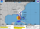
635 AM EDT Wed Sep 28 2022
...IAN RAPIDLY INTENSIFYING...
...CONDITIONS RAPIDLY DETERIORATING ALONG THE SOUTHWEST FLORIDA
COAST...
Recent data from a NOAA Hurricane Hunter aircraft indicate
that maximum sustained winds have increased to near 155 mph (250
km/h). A special advisory will be issued by 7 AM EDT (1100 UTC) to
reflect this change and update the forecast.
SUMMARY OF 635 AM EDT...1035 UTC...INFORMATION
----------------------------------------------
LOCATION...25.9N 82.8W
ABOUT 65 MI...105 KM WSW OF NAPLES FLORIDA
ABOUT 80 MI...130 KM SSW OF PUNTA GORDA FLORIDA
MAXIMUM SUSTAINED WINDS...155 MPH...250 KM/H
PRESENT MOVEMENT...NNE OR 15 DEGREES AT 10 MPH...17 KM/H
MINIMUM CENTRAL PRESSURE...936 MB...27.73 INCHES
$$
Forecaster Papin/Blake
iGRXY
Member
Yeah that is the most complete eyewall I’ve ever seen on a storm. I said 150 mph at landfall but that might be conservative at this point.
Here's Storm Chaser Thread on You Tube.
That’s hurricane Andrew old YouTube video caliber eye wall.Yeah that is the most complete eyewall I’ve ever seen on a storm. I said 150 mph at landfall but that might be conservative at this point.
BHS1975
Member
May be 180mph at landfall. Horrific.
Sent from my iPhone using Tapatalk
Sent from my iPhone using Tapatalk
Not surprised Ian keeps getting stronger up to landfall. I said from the beginning this is what we have seen with hurricanes the past few years, especially in the Gulf. I think it's the new norm with hurricanes in our current climate. I think it could keep a lot of its strength after it crosses FL, too, depending on how fast it is moving.
BHS1975
Member
This will grind slowly ashore too.
Sent from my iPhone using Tapatalk
Sent from my iPhone using Tapatalk
Z
Zander98al
Guest
Wonder if the run to CAT 5 is almost complete ?.
BHS1975
Member
Not surprised Ian keeps getting stronger up to landfall. I said from the beginning this is what we have seen with hurricanes the past few years, especially in the Gulf. I think it's the new norm with hurricanes in our current climate. I think it could keep a lot of its strength after it crosses FL, too, depending on how fast it is moving.
Not sustainable either.
Sent from my iPhone using Tapatalk
Psalm 148:8
Member
- Joined
- Dec 25, 2016
- Messages
- 344
- Reaction score
- 789
Cat 5 for sure.. one for the history books… I sure hope those people saw Michael and Katrina and got the heck out long ago!!!
EMTime
Member
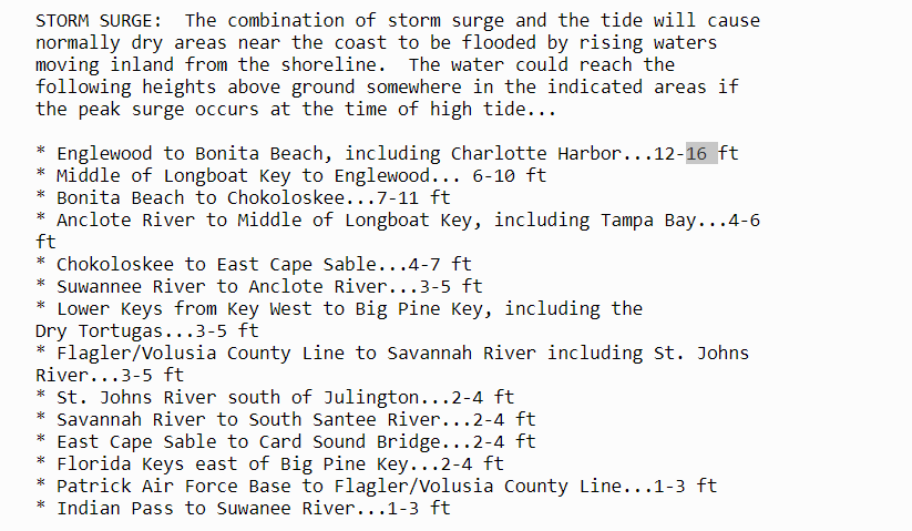
I wonder what the storm surge will now be in the worst areas?
It Was 12, 15 possible now with the strengthening?
It Was 12, 15 possible now with the strengthening?
BHS1975
Member
Cat 5 for sure.. one for the history books… I sure hope those people saw Michael and Katrina and got the heck out long ago!!!
Not gonna be anything left to come back to.
Sent from my iPhone using Tapatalk
DadOfJax
Member
Stop with the sensationalism....its tiring.Not gonna be anything left to come back to.
Sent from my iPhone using Tapatalk
mydoortotheworld
Member
Add Ian to the growing list of “hurricanes that RI’d up right until landfall”
iGRXY
Member
This additional strength makes that 2nd LF even more tedious as you really could have a cat 1 or 2 exiting Florida
So, in a storm of modeling inconsistency....I would say 1, that I can think of quickly, was the fact that this area near the coastline was the "BEST" shot at keeping strength and or strengthening to landfall. ie the only spot in the GOM that this wasn't going to get torn apart by shear and dry air *ie NGOM*
SimeonNC
Member
Now the SE eyewall is popping off, it just doesn't stop.
Woke up to a 5
EMTime
Member
I would not be a bit surprised if they're gusts of 180 to 190 atm.
BHS1975
Member
Stop with the sensationalism....its tiring.
Lol I'm not the only one.
Sent from my iPhone using Tapatalk
I’m not exactly sure where to go. Thoughts?
Shaggy
Member
No reason to think his winds wont still go up as he reacts to these sharp pressure falls
938mb? I see that right?
EMTime
Member
This is truly terrible. Hundreds of billions in damage likely, and of course the human toil we shall see.
I'm two states away and my ems company has already been called and told to be prepared to send help.
I'm two states away and my ems company has already been called and told to be prepared to send help.
Wherever it is, you better find elevation - that's hard to find there.I’m not exactly sure where to go. Thoughts?
The storm surge is going to be wicked; and there are no escape routes.
DEPENDING ON HOW BRAVE YOU ARE AND HOW MUCH YOU VALUE YOUR LIFE ID GO FOR FORT MYERS, OR CAPE CORALI’m not exactly sure where to go. Thoughts?
EMTime
Member
If you can't get out, go up.
iGRXY
Member
This could be an instance where they go back and reclassify as a cat 5 at the end of the season but this thing is coming to a crawl and has hours over water. Storms firing on the east and southeast side now so looks like the eastern eyewall is catching up to the west. With a fully closed eye and one that’s clearing out, cat 5 seems almost certain at this point.
Arcadia
I SEE 937mb938mb? I see that right?


