Itryatgolf
Member
I would take a very warm December to have a cold jan-march every winter


So Huntsville is snowier than Bangor Maine! All in on this outlook!
Sent from my iPhone using Tapatalk
Almost nailed the 85 Rain / Snow line.
Sent from my iPhone using Tapatalk
Sent from my iPhone using Tapatalk
I can believe the dry, been that way for 7 months now!
Sent from my iPhone using Tapatalk
Big west -NAOYou got to love the mild and wet in NORTH Maine, with cold and snowy south of there. And the mild and snowy out west. Sunny and hot with a chance of blizzard!


 www.severe-weather.eu
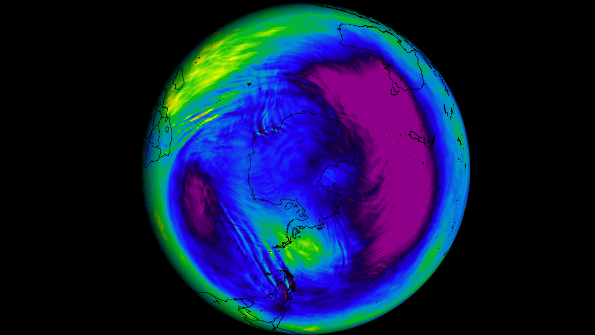
Good read… I seem to remember that the consistent -NAO of the winters of ‘09-10 and first half of ‘10-11 was preceded by an eruption thought I’m can’t remember where.Wasn't sure where to put this, and my apologies if it's been covered elsewhere, but here is a very fascinating article about the January eruption of Hunga Tonga and the current significant cooling in the stratosphere, with possible indications for the upcoming winter. Lots of good detail and maps here for even this layperson. Check it out guys.
A substantial stratospheric cooling event is now being observed over the Southern Hemisphere following a massive injection of water vapor
Latest data shows a strong cooling event unfolding in the southern stratosphere, potentially influencing the global weather patterns
We won’t have to deal with a sleet snow line this time temps are in the 20s
There were several VEI 4 eruptions in the southern hemisphere in 2008/2009, and one in the northern hemisphere. Tonga was atleast a VEI 5, but I bet we learn that it's a VEI 6, similar to Pinatubo (1991). I've never seen sunsets as pink as they are now.Good read… I seem to remember that the consistent -NAO of the winters of ‘09-10 and first half of ‘10-11 was preceded by an eruption thought I’m can’t remember where.
When I saw that date I thought oh no we are going to be torching by then. If it was 1/18 I'd actually think we'd have a chance at a snow gameSo I just saw that Hurricanes outdoor game at Carter-Finley is scheduled for 2/18/23. Watch this year be the full on torch LaNina February that hasn’t happened the last two years and it be 80 degrees in Raleigh that day.
They picked mid feb? Bad . Averages are climbing fast by then alongside sun angle !So I just saw that Hurricanes outdoor game at Carter-Finley is scheduled for 2/18/23. Watch this year be the full on torch LaNina February that hasn’t happened the last two years and it be 80 degrees in Raleigh that day.
I agree… honestly mid Feb is a crap shoot any year. I would have some time between 1/5-1/20.They picked mid feb? Bad . Averages are climbing fast by then alongside sun angle !
I really want to see how the pv is going to be honest. Gut feeling is chunks of torch and cold, cold November relaxing and warming for the first 2/3rds of December, back to cold for the end of Dec and first half of Jan with a relaxation to probably slightly AN for the 2nd half of January, solidly AN in Feb then cold sometime in mid March to early April. Globally things haven't changed much vs last winter so the expectation should be similar but the PV is a wild card and maybe we see a little more north Atlantic blocking this year vs last. It likely composites out at 2-4 AN for the season for most of the SESD, what are your early thoughts on winter? I know it's early. Do you think it will be more pacific driven if we get cold weather east of the rockies or will the nao be negative more this winter?
I wouldn't be surprised if we average out at normal temps and slightly below normal precip for DJF in the eastern sections of the southeast. I think we see recurring bouts of west based -NAO and I think it will deliver some cold during the ridging periods.I really want to see how the pv is going to be honest. Gut feeling is chunks of torch and cold, cold November relaxing and warming for the first 2/3rds of December, back to cold for the end of Dec and first half of Jan with a relaxation to probably slightly AN for the 2nd half of January, solidly AN in Feb then cold sometime in mid March to early April. Globally things haven't changed much vs last winter so the expectation should be similar but the PV is a wild card and maybe we see a little more north Atlantic blocking this year vs last. It likely composites out at 2-4 AN for the season for most of the SE


? ?Euro Snowfall Dec/Jan vs AverageView attachment 121241View attachment 121242
The article for that was published in AprilEuro Snowfall Dec/Jan vs AverageView attachment 121241View attachment 121242
Is it ever too early to be looking at winter?? Mark my word, winte ‘23/‘24 will be discussed before this coming January!The article for that was published in April
It was September 4th, 2022. Europeans write the date differently. They write the day first so the article says 04/09/2022. The article just above it for Hurricane Danielle is dated 06/09/2022.The article for that was published in April
Oh, that hadn’t even occurred to me. Thanks for letting me knowIt was September 4th, 2022. Europeans write the date differently. They write the day first so the article says 04/09/2022. The article just above it for Hurricane Danielle is dated 06/09/2022.


I sure hope so! Warm US , let Americans save on energy costs as it’s expensive . Europe can freeze , can’t be above average forever . They have been above average for well over a decade now. Western Europe that is .Lets FULL send, our Winter to the #EU & Europe, they need it ya know.. ?????

I get that Siberian snow cover can be an important factor, especially when patterns set up that promote a cross polar flow. However we’ve seen plenty of years recently when above average Siberian snow cover didn’t equate to below average winter temperatures in the southeast.Here's the CFS for the next month. A good snow base in Siberia would really help the cold air intrusions this winter.
View attachment 121357
That's true, but all the same, personally I'll take the cryosphere as cold as with much snow pack I can get.I get that Siberian snow cover can be an important factor, especially when patterns set up that promote a cross polar flow. However we’ve seen plenty of years recently when above average Siberian snow cover didn’t equate to below average winter temperatures in the southeast.
Honestly seems almost every year though it’s got a deeper snowpack than normal . Too much though and we got a strong polar vortexThat's true, but all the same, personally I'll take the cryosphere as cold as with much snow pack I can get.
