The Fake News AlmanacWhich almanac is this?
-
Hello, please take a minute to check out our awesome content, contributed by the wonderful members of our community. We hope you'll add your own thoughts and opinions by making a free account!
You are using an out of date browser. It may not display this or other websites correctly.
You should upgrade or use an alternative browser.
You should upgrade or use an alternative browser.
Pattern Winter outlook 2022/2023
- Thread starter whatalife
- Start date
Iceagewhereartthou
Member
Good thoughts on the upcoming winter that make a lot of sense.I think those 2 tricky words we aren’t allowed to say here has played a big role into what normal drivers are suppose to do. As we have seen all it takes is one piece of the puzzle not to act correctly and the response down stream has been completely different.
For example we have been in a La Niña pattern for now 3 years which should tell you we should be front loaded and overall drier everywhere in the southeast with SER dominating by the time February roles around. That hasn’t been the case. Last December was brutally warm until a switch hit in January and we were extremely cold and active all the way through a good portion of February when the SER should be in full force.
The MJO plays the biggest role versus just the ENSO. You get a favorable MJO and the pattern is at your mercy. Biggest thing I’m looking for is if the NAO remains negative through a good portion of winter like the last couple years but can we just get even a neutral or slightly positive PNA. When those ingredients came together last year we got snow and several other opportunities.
Overall I think we end up with about a 6 week period of cold and active pattern wise but the rest of winter will be East Coast ridge dominated but will be fighting NAO a lot too so it may not be as stout. Likely the CAD areas of NC, SC, and NE Georgia end up getting a lot of cold rainy or dreary days from the East Coast ridge that’ll always happen forcing CAD’s to dominate. I think we can get 1-2 storms but the question is will it be snow or the widespread ice storm that we are way past due for around most places finally happens.
For last winter, though, I never saw any "extremely cold" pattern; it never got below 20 at my house the entire winter, which is the first time that has ever happened IMBY, even with 2011-12. I'm hoping for some actual cold this year; most years I can count on at least one or two nights in the single digits, so it would be nice to at least go sub 15. I honestly don't hold out much hope for cold and snow any more, but we'll see. A +PNA and -EPO would be nice!
Itryatgolf
Member
Hey guys. I told Larry in mid December last year that with the east based niña, that it will be colder than most people forecasted, which ended up correct. Pacific was in decent shape. Pattern changed and it turned out colder for jan-march. This winter we should have the +qbo with higher sunspots, which should lead to more blocking, if correct of course. The opposite is usually true with -qbo and lower or no sunspots. I believe December will be colder than jan-march next winter. Just my two cents. I moved to jackson tn in April from Jonesboro ar so I probably will see less winter weather than where I was before ?
Last edited:
severestorm
Member
The NAO is screaming positive. Still time for it to hopefully turn lower.

A good tip is to not look at these parameters to determine how winter will turn out in august
severestorm
Member
Good point! I'm such a winter weather weenie lolA good tip is to not look at these parameters to determine how winter will turn out in august
Giddy up


I want to know who coined the term, "winter battle zone." I cringe every time I see it.
iGRXY
Member
It's lazy. Plus his maps don't make sense. How is the MA and Northeast in above average and below snowfall but going to get huge snows.I want to know who coined the term, "winter battle zone." I cringe every time I see it.
Avalanche
Member
You know that winter battle zone is more east-west based.I want to know who coined the term, "winter battle zone." I cringe every time I see it.
")
smast16
Member
I was coming to say the exact same thing. His Below average snowfall line different from his 'Tons of Snow' line by a few hundred miles. Look at Southern PA and WV.It's lazy. Plus his maps don't make sense. How is the MA and Northeast in above average and below snowfall but going to get huge snows.
Is that the Direct Weather guy on YouTube?I was coming to say the exact same thing. His Below average snowfall line different from his 'Tons of Snow' line by a few hundred miles. Look at Southern PA and WV.
NoSnowATL
Member
Battle zone- 37 straight years. Yay
whatalife
Moderator
Yes. LOL!Is that the Direct Weather guy on YouTube?
How does that knucklehead get thousands of views on all of his videos?! Extreme storms!!!!1! Serious storms!!!!111!1 Monster storms!!!!1!1!!111!!Yes. LOL!
All in a quiet and benign pattern. Who is watching that person?
Someone that should be watching our YouTube channelHow does that knucklehead get thousands of views on all of his videos?! Extreme storms!!!!1! Serious storms!!!!111!1 Monster storms!!!!1!1!!111!!
All in a quiet and benign pattern. Who is watching that person?
Itryatgolf
Member
The euro and ukmet seasonal are going -nao for winter, but it's early yet. I believe they went +nao for last winter and was correct
severestorm
Member
Ice coverage in the arctic is looking good going into the winter

Your PFP ???Yes. LOL!
Still historically low. There is a study/theory that says more open (less ice) Arctic water promotes more blocking. But if that was true where was all our blocking these past 20 years.
smast16
Member
This is where they come up with another 3 letter acronym to explain why their previous 3 letter acronym didn't pan out. IOD, PNA, PDO, MJO, SSW Etc etc.Still historically low. There is a study/theory that says more open (less ice) Arctic water promotes more blocking. But if that was true where was all our blocking these past 20 years.
severestorm
Member
It's almost a million square km above the 2011-2020 average.Still historically low. There is a study/theory that says more open (less ice) Arctic water promotes more blocking. But if that was true where was all our blocking these past 20 years.
Winter vs spring battle zone 
smast16
Member
Man I'm not sure I buy a full torch winter but it's not off the table unfortunately
You would have to bet for a warmer winter with the la nina still ongoing. I guess the one good aspect is we should see a better chance of very cold outbreaks (within the overall warm winter) that could also come with snow (..we can hope).Man I'm not sure I buy a full torch winter but it's not off the table unfortunately
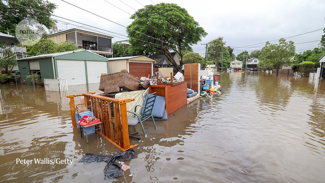
Rare ‘triple’ La Niña climate event looks likely — what does the future hold?
Meteorologists are forecasting a third consecutive year of La Niña. Some researchers say similar conditions could become more common as the planet warms.
 www.nature.com
smast16
Member
I see no reason for anything but a 3peat here. Overall above average with a 2-3 very below average outbreak somewhere in January or early early February.Man I'm not sure I buy a full torch winter but it's not off the table unfortunately
It's not a terrible pattern for cold for my location, but I could go for a good El Nino SSJ fire hose right about now.
Itryatgolf
Member
Ben Knoll from twitter mentioned the euro and ukmet guidance going negative nao for at least first half of winter this upcoming winter. It would be nice to see that. Like I always say if we can get one winter storm, im content until the following winter. I feel that early if we are to see that scenario
You would think with 3 Niñas in a row that one should behave like a traditional one with lot of cold and storm chances the first half and then a warmup and early spring arriving in FebruaryBen Knoll from twitter mentioned the euro and ukmet guidance going negative nao for at least first half of winter this upcoming winter. It would be nice to see that. Like I always say if we can get one winter storm, im content until the following winter. I feel that early if we are to see that scenario
His model blend also shows well below normal snowfall for the winter.Ben Knoll from twitter mentioned the euro and ukmet guidance going negative nao for at least first half of winter this upcoming winter. It would be nice to see that. Like I always say if we can get one winter storm, im content until the following winter. I feel that early if we are to see that scenario

His model blend also shows well below normal snowfall for the winter.
Gotta build the snowpack to the north right? Good CAD source region …?! Dry cold CAD incoming
smast16
Member
His model blend also shows well below normal snowfall for the winter.
That's a pretty classic LA Nina precip map.
Itryatgolf
Member
Our avg snow is only 5 inches a year in my area but me being optimistic hopes we see alot more than that. They say it only takes on storm to make up for a whole season or even two sometimes.
It’s just that these last two years have not acted like classic Niñas.That's a pretty classic LA Nina precip map.
LickWx
Member
Yea winter hasn’t torched like a true nina really ! No 2012 yet .It’s just that these last two years have not acted like classic Niñas.
iGRXY
Member
MJO is still the biggest driver of the pattern IMO. You get into favorable phases in the MJO and you get a storm like last year where most people got above average snowfall. On top of that it was quite cold for a good 6 week span of January- Mid February. Not quite sure what that time span will be this year but even La Niña generally gets some really cold outbreaks so it won’t surprise me to see another 3-6 week stretch of really good temperatures and increased snowfall chances.
Hard to believe we go all winter without at least 1 favorable period of a few weeks of some good chances for winter precip. And honestly we usually have a period in any winter but if the last two years are any indication of what’s to come.. I would be at least a little excited for that possibility. But also don’t forget .. more than likely we will torch at some point as well.. but hey that’s the name of the game in the south. If we could get that NAO block earlier than we did last year that could bode well for more impactful winter weather. 
I would say last December was a torch. 3rd warmest on record for KCLT and the last week saw lows everyday 5-10 warmer than average highs. A true Niña though would have seen warmth like that in February and that cold period the last 3 weeks of January and first half of February would have been before.Yea winter hasn’t torched like a true nina really ! No 2012 yet .