whatalife
Moderator
Post away your thoughts and ideas on our upcoming 22/23 winter. Should be a blast.


I think your phone may have aidsAll in on this one! Everybody winsView attachment 120439
Monkeypox ebolaids cancerI think your phone may have aids
I’m hoping for a lot of Lakes cutters and or Clippers!Same as every other year. Cold Midwest down into TX up through western TN and the Great Lakes. Warm in the SE and along the east coast up into the NE. Who cares about the west.
I'm thinking above average snowfall for a good chunk of SC and NC, due to a couple of La Nina coastals....probably N GA too. Trickier back in AL and MS, where it will probably be drier than normal. I will go near normal snowfall there.
Cold most likely in early December and late Jan/early Feb. Maybe a cold shot early March, but spring comes in quickly. NAO predominantly positive and the PNA averages near neutral for the winter. Meh.
 ️
️??I think your phone may have aids
FixedThis is going to be the most warmest winter of our lifetimes.


April.I dont care if we're above or below average, give me a week straight of CAD.
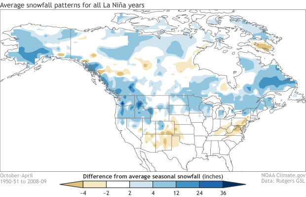
That would actually be ok with me, I’m now believing the SJ is much more hinders snow for the SE than helps.I think the Pacific NW will fair very well this winter with Nina and the NPO inducing persistent troughs over the West. It's going to be threading needle again this year without a strong subtropical jet. Hopefully we get a good snow storm out of it though!


I sure hope so. Love a cool spring. Anything to delay summer around here.April.

Texas has had 2 cold Febs in a row.. so it's either this one or the whole country roasts...I’ve been trying to get this map to hit since my 2017 winter prediction. Let’s try again View attachment 120522
I'd take a December 2000 repeat. Solid snow cover for 2 weeks and epic sledding. Though I did tear my labrum.could look like this or could be totally different lol. guess depends on if this year's "triple dip Nina" behaves like the last two and what the NAO/AO decides to do.
can confidently say it will snow in Dubuque and not snow in Key West - everybody in between just wait and see lol
View attachment 120469
View attachment 120470
View attachment 120471
View attachment 120472
View attachment 120473
Ollie, Can you post one for KRDU?Euro Seasonal Snow Meteogram for Greensboro.
View attachment 120495
I don't have access. I got it off TwitterOllie, Can you post one for KRDU?
The other one is even betterFarmers Almanac out. Not bad really...if to be believed.
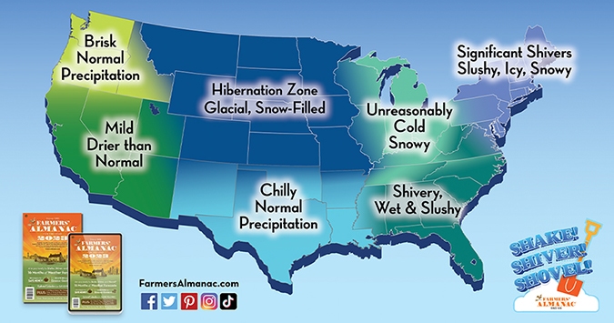

Which almanac is this?The other one is even betterView attachment 120572
The Old Farmer's Almanac 2023Which almanac is this?