iGRXY
Member

Maybe a hair SW.


GFS , no it's not been consistent, it's moving back south again after moving north
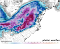
The majority of that rain in the upstate is likely going to either be snow or ICEDefinitely a significant winter storm in central NC, IP/zr/sn/rn... all of it
Overperforming frontend thump coming, you love to see it.
Putting down more SN to the west in MS and northern AL.
Overperforming frontend thump coming, you love to see it.
Yeah, I tend to honestly expect IP to be the dominant P-type across Central NC with this storm at this point.Did you miss the NAM images earlier? There will be a large area of IP
I definitely think that the convection-based models will have a better handle on the 850s. I am buying the NAM/RGEM camp with less snow further east at this point. It further will be interesting to see the 3k models come into range.
Looks like it's sitting right along the 0c 850 line. Either going to rip fatties or face stinging sleetOverperforming frontend thump coming, you love to see it.


Looks like the typical I-85 special right there. We should know that's how most storms around here go. A few miles up the road and its snow.sounding for clt, ip but so close to a snow sounding it hurts.
View attachment 104980

I’m leaning towards us staying below freezing for the duration, possibly the upper 20s, but from what I’m seeing on these soundings, I really think that after that front end thump of snow, we’re gonna see sleet dominate with some ZR until whatever snow the backside brings. I wouldn’t be at all suprised at all if the corridor from eastern CLT metro up to the west side of the triangle has a solid concrete glacier on the ground by Sunday eveningFor areas further west such as Charlotte and the 85 corridor, are we looking at staying below freezing for the duration of the event? If so then we likely have a huge ice storm on our hands.