Still a major wedge signature under heavy precipitation, lots of ice. Icon maps don't show ice.
-
Hello, please take a minute to check out our awesome content, contributed by the wonderful members of our community. We hope you'll add your own thoughts and opinions by making a free account!
You are using an out of date browser. It may not display this or other websites correctly.
You should upgrade or use an alternative browser.
You should upgrade or use an alternative browser.
Wintry Jan 15-16 Winter Storm Discussion & Obs
- Thread starter SD
- Start date
iGRXY
Member
ICON actually has less mixing and keeps the northern upstate snow for quite a bit longer.
Gotta be more inclined to believe the ICON with its evolution in such a strong CAD event .. an eventually climb above freezing for a time but a much longer period of freezing temperatures for a longer duration for a lot of central NC .. I just don’t believe this erodes away as fast as the GFS has been printing out
Oh I know what you’re saying. However those past GFS runs had a low track much further north than what the NAM just showed and it’s following other guidances. With the more southerly track, the forcing to set up that pre-event comes further south as well. This is something that I’ve seen a number of times with a low track like this…the January 2002 storm is just one example of itThere’s a difference between the initial snow thump and the pre event..some modeling (past gfs runs) suggested a band of snow coming out of Kentucky and threatening Boone to Winston Salem and southern Virginia 6-12 hours before the precip even starts in the CLT metro.
Ice with a few inches of heavy wet snow will be a nightmare. The ice on the trees and power lines will allow the snow to stick like glue when it may other wise fall off.If the NAM is to be believed then in Georgia your getting hit with a major freezing rain then getting anywhere between 2-6 inches depending on location on the backside snow on top of that... That's power outages glory and frozen everything insulted by snow nice... :/
Plus Temps on Monday high is 40 partly cloudy and that doesn't factor in the snow etc on ground which in these events we always know causes temps to never verify on the high. Tuesday will have similar issues all be it sunnier but your probably not getting very far around parts of GA to Wednesday to be honest.
ICON has been consistent in showing this low almost wanting to ride the edge of the wedge to the coast which is how I would expect a low pressure to act in this scenario
NAM can well be the NAM...lol but the changes *since it has been sampled fully now* are really encouraging if you want wintry weather for many on this board. GFS And EURO will be telling today.
TigerSnow
Member
Thanks for that info. I was curious if it showed ice or not because it looked like all rain.Still a major wedge signature under heavy precipitation, lots of ice. Icon maps don't show ice.
12z RDPS

On the 12z run it now only has RDU briefly jumping above freezing. Even then that occurs with a lull in the precipitation; so most has ended up falling as frozen/freezing.Gotta be more inclined to believe the ICON with its evolution in such a strong CAD event .. an eventually climb above freezing for a time but a much longer period of freezing temperatures for a longer duration for a lot of central NC .. I just don’t believe this erodes away as fast as the GFS has been printing out
For those who missed it; I think it was said Ryan Maue likes the RDPS over the NAM and that guy lives and breathes models!
SouthGarnerSleet
Member
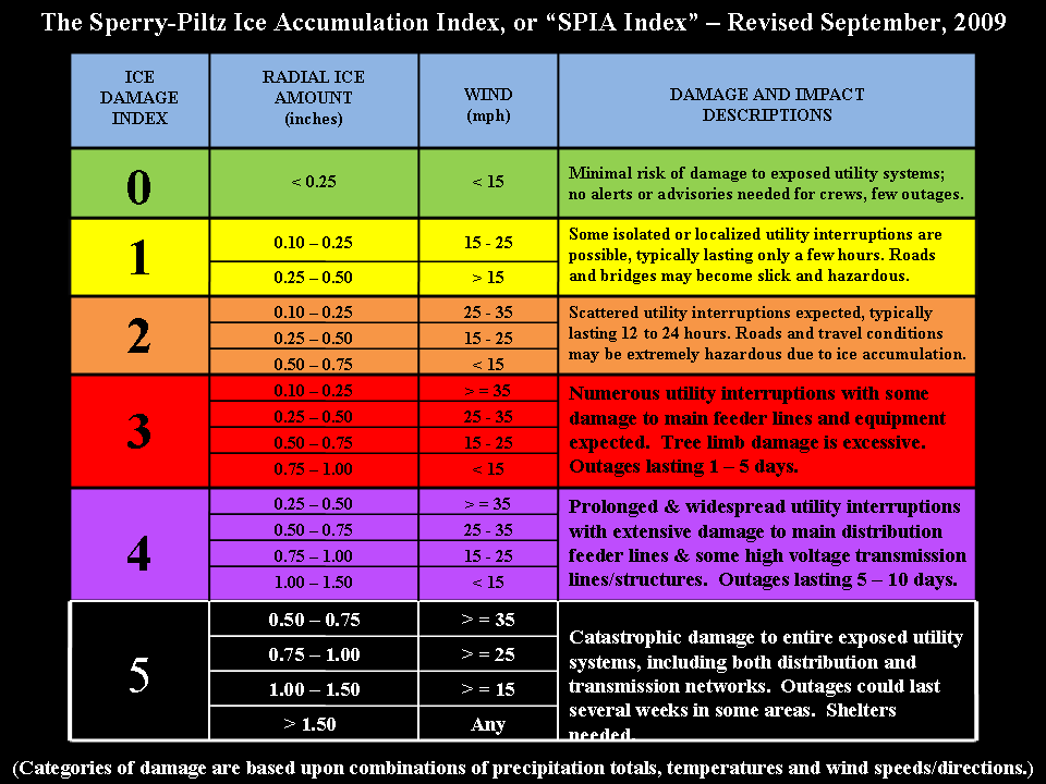
Even if you knock off the totals by half, with the expected 20 to 30 mph winds and maybe gusts up to 35, we're still seeing a widespread 3 on this scale. Worst case is a 5 through charlotte area so I'm hoping we don't see that much ice.
Every storm there are models that pump crazy ice totals which, to nobody's surprise, never pan out.
Icon precip evolution gives me anxiety issues I feel like there would be at least a non-zero chance of a Carolina split with qpf on the east side of Charlotte to Raleigh.
iGRXY
Member
Would the RDPS have access to the new data that we got this morning yet? I figured the American models would.12z RDPS
The ICON was about six hours faster with the upper features than the NAM and its own 6Z run. This is probably why surface temps ticked up a tad in N Ga. By hour 81, it places the vort max over Augusta! I'll take my chances with that set op

He also said the ICON was a great model and those 2 have a slightly different SLP track right now, going to be interestingFor those who missed it; I think it was said Ryan Maue likes the RDPS over the NAM and that guy lives and breathes models!
What we really want to see on the Euro/GFS is the ULL to go negative tilt about the MS/AL line.
Edit: On second thought Montgomery would be better.
Edit: On second thought Montgomery would be better.
LOT of precip from Charlotte to Columbia on the RDPS....and not finished here

I think its a growing trend *hopefully continues* that the northern and central parts of AL and GA see some snow under the ULL/Comma head.Ice with a few inches of heavy wet snow will be a nightmare. The ice on the trees and power lines will allow the snow to stick like glue when it may other wise fall off.
Ehh, that's a pretty significant jump with the LP almost in coastal areas of SC to move to near Florence. I'd need to see more consistency before I buy into a jump like that.12z RDPS
RGEM speeding up the energy and trending it SE.

Snowflowxxl
Member

I suspect, in general, all modeling organizations share the observational dataWould the RDPS have access to the new data that we got this morning yet? I figured the American models would.
Seems to be the only model picking up on a large area of sleet .. meaning there’s probably still some things to be worked out with our CAD conditions12z RDPS
LovingGulfLows
Member
- Joined
- Jan 5, 2017
- Messages
- 1,499
- Reaction score
- 4,100
I'm really liking the fact that even if the frontend of the storm system dissapoints for my area, there's a growing chance of measurable snowfall on the backend with the upper level low.
Did you miss the NAM images earlier? There will be a large area of IPSeems to be the only model picking up on a large area of sleet .. meaning there’s probably still some things to be worked out with our CAD conditions
Also looks like the 50/50 is holding in longer and getting a better cold push
If we can get the Euro on board I would feel much better. Heck 2 inches across AL would be another huge win on par with the one a week or so ago.I think its a growing trend *hopefully continues* that the northern and central parts of AL and GA see some snow under the ULL/Comma head.
If I was in charge of deploying teams for networks I would send someone to Gainesville GA, Charlotte NC, Statesville NC and Boone NC. That will pretty much cover onset ice, city ice, sig ice and sig snow. If I was Jim Cantore I would be in Virginia.
I really think these models often times have difficulty distinguishing between sleet and freezing rain… I’m noticing a lot of these frames where it’s showing me getting ZR and at the end of the run over an inch, I go back and pull the soundings were actually showing sleet.Seems to be the only model picking up on a large area of sleet .. meaning there’s probably still some things to be worked out with our CAD conditions
As @packfan98 stated last night, I know many are on map overload lol and I'm not sure if the final ICON snow map was posted, if I missed my apologies but I'd think the Wake Co crowd would like this improvement for sure

What an evoloution to a craptastic Storm track this week. How we get the inland coastal plain track from South Al is how you find a way to screw up a SECHS. Sleet looks to save me, but really gonna have to do Generator checks etc tommorrow. There is someone who is gonna get .75-1.0 freezing rain out of this.
Blue_Ridge_Escarpment
Member
I see very little changes through 42 on GFS.
I did not miss here is NAM with a much larger area of freezing rainDid you miss the NAM images earlier? There will be a large area of IP

RGEM drops over a foot on Memphis and still going at the end of the run.


Was it going due east or like north east?RGEM drops over a foot on Memphis and still going at the end of the run.
View attachment 104968
View attachment 104969
Were ****** now lol and not a good sign with the Nam seen this dance before....Cantore arrived at CLT last night. Going to be stationed in WNC somewhere.
The 12z GFS looks a tick further west, but the 50/50 low is a good bit further west.
iGRXY
Member
GFS is a little weaker at 54