NBAcentel
Member
HRRR is pretty fast compared to the NAM
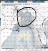
What’s that showing the graphLol Hodograph View attachment 79177View attachment 79178
That is a great look for storms but I have to wonder if that deep convection to the south is gonna kill moisture returns over southern VA and northern NC. Would also mean CAPE doesn't build like the model depicts.Looks the the HRRR is quicker but was still about to fire up a second round of storms over the NC peidmomt View attachment 79172View attachment 79173View attachment 79174View attachment 79175
Honestly these type of fronts always come in quicker than models show .. once those winds hit the ground they scrape the land fast and storms always arrive a few hours earlierHRRR is pretty fast compared to the NAM
Yeah it’s that vs a mid level dry slot trying to clear things outThat is a great look for storms but I have to wonder if that deep convection to the south is gonna kill moisture returns over southern VA and northern NC. Would also mean CAPE doesn't build like the model depicts.
HRRR really shows that junk convection.. usually ruins the show for many
Here's to hoping the show gets Bleeped on per Brick!!!HRRR really shows that junk convection.. usually ruins the show for many


I wouldn’t talk in absolutes. While that is usually the case ATL had a EF2 rip right through the city in 2008 and was only under a “MARGINAL” risk. Anything can happen even though we get spared far more than not.
Yeah that secondary round is becoming a legit issue, dry slot aloft clears things out in the mid and upper levels, low levels is a questionSo far the 18z NAMs have looked fairly ominous regionally
Yeah probably becomes a stout hail/wind threat for us late Thursday afternoon. Really didn't like how things are setting up on the NAMs in MS into Al. There are a few detractors there but it still looks rough out that way tomorrow afternoon and eveningYeah that secondary round is becoming a legit issue, dry slot aloft clears things out in the mid and upper levels, low levels is a question
A potent and compact low-amplitude trough will move from the
Southern Plains on Wednesday to the Lower Mississippi Valley
Wednesday night, preceded by a 60-80kt mid-level speed max and a
40-50kt LLJ. A 998mb surface low will track from Oklahoma to
Illinois with a broad warm sector with mid to upper 60s dew points
in advance of a cold front. Shortwave ridging/anti-cyclonic flow
aloft is forecast to develop Wednesday morning which should allow
the early morning showers/storms to move out of the area. This
will allow for heating and ample destabilization. CAPE values will
increase to 2000 to 3000 J/kg across much of the area by
afternoon. Forecast soundings indicate the air mass across the
warm front will be uncapped across the warm sector by afternoon,
and CAMs are in fairly good agreement on scattered to perhaps
numerous supercells developing in the 1 to 4 PM timeframe. Low-
level SRH is less than 200 m2/s2 initially during the afternoon,
so large, potentially significant hail may be the main threat
initially with 50 to 60kt of 0-6km shear aiding updraft rotation,
but a couple isolated tornadoes will still be possible. For
simplicity, will start the threat time at 2 PM everywhere to
account for this activity. After 4 PM, the 850mb jet and
associated SRH begins to really ramp up across West Alabama, and
across the rest of the area by 6 to 7 PM. This is when concern for
strong, potentially long track tornadoes will begin to ramp up
with any semi-discrete supercells still present. We will also be
monitoring mesoscale trends closely for the possibility of a
violent tornado. It`s hard to find too many limiting factors for
this event, but if I had to mention one it might be if too many
storms get going too early before the low-level shear increases.
However with the strong low-level jet and activity remaining
cellular I don`t see this being much of a limiting factor. Will
also need to monitor the northward movement of the wedge front. It
could limit the afternoon threat across some of our far northeast
counties, but also serve as an additional source of helicity for
storms near the warm side of it. I do expect the wedge front to
exit the area prior to the overnight activity.
During the late evening and overnight hours, another strong line
of storms will move in from the west ahead of the cold front.
Shear vector orientation has a component normal to the line and
the magnitude is strong as well. This will be favorable for
embedded supercells in the line or a semi-broken line of
supercells, therefore this activity will also be a concern for
strong to intense long-track tornadoes, not just weak QLCS spin-
ups. Additionally, any bowing segments will have a significant
wind threat as well. Outside of storms, gradient winds near 35 mph
will be possible, and will monitor for the possible need for a
wind advisory. Activity will remain fairly progressive and
antecedent conditions still fairly dry, limiting the overall
flooding threat, but some minor flooding in poor drainage areas is
possible, and some rivers are forecast to be near or above flood
stage.
hate to say it but if the 00z NAM comes in similar, probably gonna get the high risk down thereYeah probably becomes a stout hail/wind threat for us late Thursday afternoon. Really didn't like how things are setting up on the NAMs in MS into Al. There are a few detractors there but it still looks rough out that way tomorrow afternoon and evening

It's possible some parts of NC and SC get to moderate if this 2nd round keeps showing up. If not, the enhanced will cover it.
April 2019I wouldn't dismiss that as a possibility. Given how what the NAM is showing. When was the last time we even had a moderate risk around these parts? It's been a while.
April 2019
Probably golf ball size at max (that’s a big if) , if theres enough instability then arguably it’s possibleHow big of a threat is hail for us? Thinking baseball potential?
 The risk for significant severe weather will increase from west to east Wednesday night into Thursday, with tornadoes, damaging wind gusts, and heavy rainfall all expected to be threats with these storms.
  A State of Emergency has now been declared for ALL 67 Alabama counties!
I guess it's only a matter of time before Georgia issues a State of Emergency for the western part of the state.⚠ A State of Emergency has now been declared for ALL 67 Alabama counties!
April 2019
⚠ A State of Emergency has now been declared for ALL 67 Alabama counties!
The Governor(s) usually do this so that schools can close or let out early without having to make-up that day.Actually,
Sounds a bit premature, but given the parameters I guess it makes sense. At the very least it'll get people to take this situation seriously. Have they closed schools and businesses yet?
NopeI guess it's only a matter of time before Georgia issues a State of Emergency for the western part of the state.
Bhm Nws seems to think tennis ball size for Bama.How big of a threat is hail for us? Thinking baseball potential?
Mike Maze on WRAL just seemed like it wouldn't be that bad here on the news.
Lol the RAP
It’s aggressive with the QLCS unlike the NAMsOh god, what is the RAAAPPP showing? Lol.