NBAcentel
Member
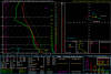
Alright severe weather threat looking more higher tomorrow 


Rich get richerAlright severe weather threat looking more higher tomorrow View attachment 47711View attachment 47712View attachment 47713
Alright severe weather threat looking more higher tomorrow View attachment 47711View attachment 47712View attachment 47713
Called it! Lol.
Btw tomorrow is still AugustYeah nam showed some solid soundings, lots of backing tomorrow/turning low level wind fields north of the NC/SC border through the NC/VA border
")
Yeah nam showed some solid soundings, lots of backing tomorrow/turning low level wind fields north of the NC/SC border through the NC/VA border
The tornado threat has me intrigued View attachment 47715


If that verifies, at least there won’t be any drought for your area this September like there was last year. I remember getting less then a quarter of an inch of rain during all of September 2019.Ugh...last run puts many of us under an atmospheric fault line. Days of rain. Thick humid and ugly.
Sent from my iPhone using Tapatalk
You are about to get smacked!Looks and sounds like a war zone outside.Non stop lighting and thunder the past 15 mins.


This seems fairly legit
View attachment 47772
Front is really going to slow to a crawl as it moves east
Actually gonna disagree with this. Believe front is just slowing down to save us and in regards to timing/tropics. Front will push it out when it decide to form.And any TCs will get pulled inland.
Sent from my iPhone using Tapatalk
Actually gonna disagree with this. Believe front is just slowing down to save us and in regards to timing/tropics. Front will push it out when it decide to form.
ThunderstormsActually gonna disagree with this. Believe front is just slowing down to save us and in regards to timing/tropics. Front will push it out when it decide to form.
Yep. Cools down the entire country except east of the apps! Book it. ?This seems fairly legit
View attachment 47772
Front is really going to slow to a crawl as it moves east
Only the 1st of many cold fronts over the next 6 months to fail miserably penetrating the Carolina shield.This seems fairly legit
View attachment 47772
Front is really going to slow to a crawl as it moves east
I've seen that happen before, especially in Sept/OctThe front getting hung up like that seems really wonky. 50’s to the gulf coast from Texas to Alabama but low 70’s in north GA for overnight lows. Though if the cold air doesn’t make it into the northeast I can understand not getting any CAD flow.
FFC by the way has no interest in this stuff. They are more interested in the oppressively hot week ahead.
Sent from my iPhone using Tapatalk
Sadly, happens all the time in winter! BNA can have highs in the 20s, while GSP to CLT bask in the 50s and 60sThe front getting hung up like that seems really wonky. 50’s to the gulf coast from Texas to Alabama but low 70’s in north GA for overnight lows. Though if the cold air doesn’t make it into the northeast I can understand not getting any CAD flow.
FFC by the way has no interest in this stuff. They are more interested in the oppressively hot week ahead.
Sent from my iPhone using Tapatalk
Sadly, happens all the time in winter! BNA can have highs in the 20s, while GSP to CLT bask in the 50s and 60s

God bless the Appalachian mountains , otherwise we could see colder records . Nashville dropped to -17 in 1985 . Yikes , not even Asheville which is significantly elevated got that cold. Knoxville dropped to -24 and it is not even at a significant elevation either !Sadly, happens all the time in winter! BNA can have highs in the 20s, while GSP to CLT bask in the 50s and 60s
Sadly, happens all the time in winter! BNA can have highs in the 20s, while GSP to CLT bask in the 50s and 60s
Those mountains also give us CAD. While we may suffer because of cold not getting across the mountains, we can score winter weather when the cold gets trapped/banked on the east side (,,as areas west of the Apps are considerably warmer).God bless the Appalachian mountains , otherwise we could see colder records . Nashville dropped to -17 in 1985 . Yikes , not even Asheville which is significantly elevated got that cold. Knoxville dropped to -24 and it is not even at a significant elevation either !
.png")
I've always wondered about the validity of that Knoxville record during the Jan '85 arctic outbreak. Chattanooga got -10, and Knox almost always runs about 3-5 degrees colder, under prime radiation cooling scenarios.God bless the Appalachian mountains , otherwise we could see colder records . Nashville dropped to -17 in 1985 . Yikes , not even Asheville which is significantly elevated got that cold. Knoxville dropped to -24 and it is not even at a significant elevation either !
Jan '94? Chattanooga got down to 1 or 2 degrees, I forget. (Official airport temp). My porch reading was -5, I recall. Also -5 in Feb '96.I wonder how cold the deep south got in 1994. It was -36 in Indiana and -37 in Kentucky !
I've always wondered about the validity of that Knoxville record during the Jan '85 arctic outbreak. Chattanooga got -10, and Knox almost always runs about 3-5 degrees colder, under prime radiation cooling scenarios.


I remember being able to walk on the pond as it was about 6"+ thick. I think that was after we picked up 1/4" of ice plus snow. Sledding was epic for days and days and I think we had highs in the teens.I wonder how cold the deep south got in 1994. It was -36 in Indiana and -37 in Kentucky !
I smell a setup where the front stalls, it’s humid and there’s rounds of daytime convection, and nighttime elevated stormsI've seen that happen before, especially in Sept/Oct
What’s CAD?Those mountains also give us CAD. While we may suffer because of cold not getting across the mountains, we can score winter weather when the cold gets trapped/banked on the east side (,,as areas west of the Apps are considerably warmer).
I smell a setup where the front stalls, it’s humid and there’s rounds of daytime convection, and nighttime elevated storms