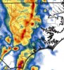
This little guy says don't ignore me and my cold pool Friday afternoon
Yep end of the NAM looked like it had some good hail producing storms Friday afternoon ... the severe season that keeps on giving I supposeThis little guy says don't ignore me and my cold pool Friday afternoonView attachment 40673


Like I said, two rounds. The main line will move into rain cooler air around 3am-5am. Meh.Pretty robust leftover mesoscale convective vortex (MCV) is evident on visible in eastern Alabama, and is causing local backing of the surface winds there. The additional low-level shear, moisture transport, & lift afforded by the eastern-southeastern flank of this MCV will become a hot spot for new convective development in Georgia and the western portion of the Carolinas later this afternoon & evening & it'll likely provide a legit wave of pre-frontal convection a few-several hours before the primary squall line comes knocking.
View attachment 40675
View attachment 40676
Like I said, two rounds. The main line will move into rain cooler air around 3am-5am. Meh.
That is an interesting feature for sure.Pretty robust leftover mesoscale convective vortex (MCV) is evident on visible in eastern Alabama, and is causing local backing of the surface winds there. The additional low-level shear, moisture transport, & lift afforded by the eastern-southeastern flank of this MCV will become a hot spot for new convective development in Georgia and the western portion of the Carolinas later this afternoon & evening & it'll likely provide a legit wave of pre-frontal convection a few-several hours before the primary squall line comes knocking.
View attachment 40675
View attachment 40676

Round one is largely after 9pm. Round two in TN is wee hours of the morning. View attachment 40683
It’s different when you have mountains and upslope that can wring out moisture and thus delay the movement East a hair. I fully expect most will sleep through this unless your in the mountains with better timing.Models were a couple of hours slow on this one yesterday right? Or was I imagining things.
Pretty robust leftover mesoscale convective vortex (MCV) is evident on visible in eastern Alabama, and is causing local backing of the surface winds there. The additional low-level shear, moisture transport, & lift afforded by the eastern-southeastern flank of this MCV will become a hot spot for new convective development in Georgia and the western portion of the Carolinas later this afternoon & evening & it'll likely provide a legit wave of pre-frontal convection a few-several hours before the primary squall line comes knocking.
View attachment 40675
View attachment 40676
And there goes the slight risk area...
Brad is terrible he didn’t expect tornado warnings for Charlotte when upstate had those three supercells. Numerous times he tells viewers last minute once it’s actually on the doorstep never in advance.Pretty much matches what Brad said on his VLOG. He is not too concerned about the chances for severe weather. The MCV is an interesting feature though. It's just odd to have so many varying thoughts. GSP says yes, SPC says meh, as does Brad. Someone has to be wrong, question is... who?
Brad is terrible he didn’t expect tornado warnings for Charlotte when upstate had those three supercells. Numerous times he tells viewers last minute once it’s actually on the doorstep never in advance.
Pretty much matches what Brad said on his VLOG. He is not too concerned about the chances for severe weather. The MCV is an interesting feature though. It's just odd to have so many varying thoughts. GSP says yes, SPC says meh, as does Brad. Someone has to be wrong, question is... who?
Brad is terrible he didn’t expect tornado warnings for Charlotte when upstate had those three supercells. Numerous times he tells viewers last minute once it’s actually on the doorstep never in advance.
Kudos to bmx they have been cleaning spec's clock here lately. Maybe they should let Birmingham do the outlooks from now on.And there goes the slight risk area...
Moving on, TN storms looking better and growing. May need a severe watch for east TN?
Man, it sure is quiet today on this thread. I was looking forward to tracking something, even if it was an elevated storm. The line coming through the Upstate has a little 'tude with it, but will it make it across the Piedmont?
Lots of wind here this afternoon for what it’s worth.
Just had a very heavy downpour. Picked up about half an inch in the last 30 minutes. With that I am closing in on almost an inch of rain for today. Also had quite a bit of wind with that shower too.Getting my second downpour of the day right now. It is really dark here.
EL temps across much of the southeast right now is puny so lightning will likely lack until later
Kitties hate storms, even heavy rain. I get more bed space?Give me a nice thunderstorm with some big boomers and I will be a happy camper!