• Hello, please take a minute to check out our awesome content, contributed by the wonderful members of our community. We hope you'll add your own thoughts and opinions by making a free account!

Possible Severe Weather April 22nd-23rd

Seems like there going with a NAM 3kmish/12kmish option, but instead the warm sector is further north, including more surface based instability, don’t know bout that one tho, but I guess you can’t argue with it, since they have done well
Yea sounds like a blend of the two. They mentioned the forecast uncertainty with outflow boundaries and a tornado risk if air mass has not been overturned.

Low-level shear for tornadoes will be most favorable early in the
day across LA/MS/AL, and later in the day across GA and SC near the
warm front. Adding uncertainty to this forecast is potential outflow
boundaries from the early day storms, and questions regarding
airmass recovery in those areas (northern GA and SC).
Tornado and
wind risk will largely depend on storm mode. If midday heating
occurs along the dryline, and the air mass has not been overturned,
supercells and tornadoes will be possible.
A few strong tornadoes
might occur should sufficient SRH (200-300+ m2/s2) remain prior to
850 mb winds veering. Tornadoes will also be possible along the warm
front into GA/SC, assuming it is not reinforced with too much
outflow. Otherwise, a general upscale growth of storms is expected
for the remainder of the area including FL. Damaging winds are most
likely should the storm mode be linear. Given such large model
variability, large changes in area are possible in later updates.
 
I still think Central AL to Central GA might be a MDT risk...Either way, I think that zone has the best intersection of CAPE and Shear.
 
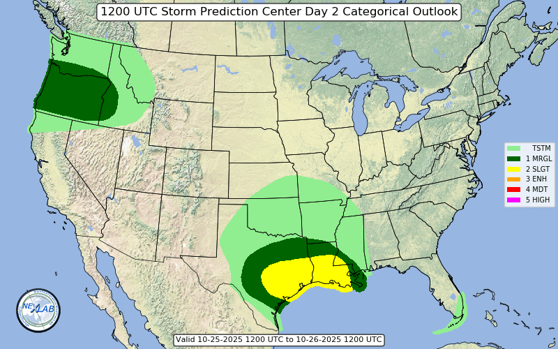
The enhanced risk for tomorrow has been expanded into the Carolinas:

swody2_categorical.png
I wonder why the enhanced risk goes almost to the VA border in NC but in GA it barely gets north of Atlanta ?
 
I don’t think most of GA should even be in an Enhanced risk, so I guess I’ll see if I’m a clown tomorrow. I just don’t see anything worth talking about forming after the morning junk

Really getting the feeling that they did this because of the uncertainty, not because of a defined definite risk. It's an enhanced risk, not moderate or high, so I guess they have less to lose if it doesn't verify.
 
well, the EURO look (looking at those maps) that is definitely an increase in parameters (at least around here)
 
The 3 o'clock forecast discussion for GSP should be interesting, to say the least.
 
I disagree with SPC. They should have worked with local NWS such as Blacksburg and Raleigh because they would have not agreed for such an outlook. Thankfully there is time for it to be downgraded tomorrow at least.
 
The SPC did this with the last event that stayed to the South. To be fair, they know what they're doing though... you don't just get to the SPC for you know, getting a basic meteorology degree.
 
The SPC did this with the last event that stayed to the South. To be fair, they know what they're doing though... you don't just get to the SPC for you know, getting a basic meteorology degree.

It was a huge jump north though, I don't think I've seen them escalate the threat that quickly. But as you said, they know exactly what they're doing and have done a pretty good job thus far.
 
It was a huge jump north though, I don't think I've seen them escalate the threat that quickly. But as you said, they know exactly what they're doing and have done a pretty good job thus far. Which is slightly concerning.
 
It was a huge jump north though, I don't think I've seen them escalate the threat that quickly. But as you said, they know exactly what they're doing and have done a pretty good job thus far.

Their discussions have all alluded to the uncertainty. I guess better safe than sorry. Reminder, we weather people look at, and hang on each of their words and forecast graphics... the general public doesn't take this stuff nearly as seriously and if they decide to downgrade, it's not going to cause mass hysteria.
 
They're discussions have all alluded to the uncertainty. I guess better safe than sorry. Reminder, we weather people look at, and hang on each of their words and forecast graphics... the general public doesn't take this stuff nearly as seriously and if they decide to downgrade, it's not going to cause mass hysteria.

I agree. They can always retract if needed. I just would have assumed they would have stuck with a slight risk but extended it north. But I definitely wouldn't argue their prediction. Better safe than sorry.
 
But I would argue it will lead to people letting their guard down in the future because forecast is likely to not live up to potential. Because people like Scotty Powell are screaming on the top of their lungs on social media saying enhanced risk for foothills. Oh well
 
Just saw the SPC put us under a level 3 risk here. Didn't expect that. I was looking more at Saturday for storms. But sounds like this has big bust potential.
 
But I would argue it will lead to people letting their guard down in the future because forecast is likely to not live up to potential. Because people like Scotty Powell are screaming on the top of their lungs on social media saying enhanced risk for foothills. Oh well

That's the thing. Those "people" who "let their guard down" aren't a factor here.

Tell me right now, one person (that you have not shown, or told) in real life, that talks about the latest SPC outlooks? (not the local mets)

Around here, I see the local media sometimes mention the outlooks and put a pretty map up and people share it. That's about as close as it gets with the general public.
 
I disagree with SPC. They should have worked with local NWS such as Blacksburg and Raleigh because they would have not agreed for such an outlook. Thankfully there is time for it to be downgraded tomorrow at least.
Honestly, you have no idea if SPC and the local NWS offices aren't talking internally...most likely they are. Most people don't read the discussions and there is plenty of time to adjust as needed.
 
The SPC did this with the last event that stayed to the South. To be fair, they know what they're doing though... you don't just get to the SPC for you know, getting a basic meteorology degree.

Well, the last few years we have had more severe storms around here when we are not under a watch of any kind. And then there are times that places have had tornadoes and severe storms before they put a watch out.
 
Well, the last few years we have had more severe storms around here when we are not under a watch of any kind. And then there are times that places have had tornadoes and severe storms before they put a watch out.

It's almost like people still believe a watch or warning will control what the weather does.

I see this constantly:
"No winter storm watch? the models must be wrong and it won't snow"
"No moderate risk, cape must not make it here."
"Surprised they didn't issue a tornado warning for that cell, that must not be a debris ball on radar then."

No one said it controls the weather. But it is up to the SPC to warn the public and they are the ones to issue the watches and warnings.
 
I disagree with SPC. They should have worked with local NWS such as Blacksburg and Raleigh because they would have not agreed for such an outlook. Thankfully there is time for it to be downgraded tomorrow at least.
Did you read the Raleigh AFD?
 
I disagree with SPC. They should have worked with local NWS such as Blacksburg and Raleigh because they would have not agreed for such an outlook. Thankfully there is time for it to be downgraded tomorrow at least.

The SPC is not part of any local NWS office. They have never worked with individual offices as far as I'm concerned. They know their stuff, man. And have done an excellent job this year in regards to severe weather. Given the parameters tomorrow, it would surprise me to see them downgrade. They put an 'enhanced risk' there for a reason.
 
The GSP afternoon AFD doesn't mention the word "tornado" a single time. Am I missing something?
Nope your not forecasts do not suggest widespread enhanced tornadoes in the GSP viewing area. Feel free to use tropical tidbits to see the strato rains tomorrow early 5am into the afternoon.
 
Back
Top