• Hello, please take a minute to check out our awesome content, contributed by the wonderful members of our community. We hope you'll add your own thoughts and opinions by making a free account!

Miserable March

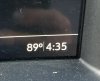
I think low-90s are a stretch, mid-80s might be possible though.

Only reason I say that is because with the past 2 warmups, the GFS was to low by 5-8 degrees, the gfs a few days ago showed temps that would be around 79 Degrees today, ended up touching 85 at my location, Hrrr often gets that BL mixing better which the GFS struggles with
 
What I don't want to see is this ridge really pump north and dry us out completely. When I was in Florida a few weeks ago it seemed really dry, granted, this is their dry period.

1584795866371.png

1584795893338.png
 
What I don't want to see is this ridge really pump north and dry us out completely. When I was in Florida a few weeks ago it seemed really dry, granted, this is their dry period.

View attachment 37496

View attachment 37497
Here in most tennessee it’s anything but dry... can’t even get out mow grass . Getting bad
 
Call me an eternal optimist, but I don’t think coronavirus has a chance once this ridge tries to flex. I’m not sure the Chinese Flu knows what it’s up against. #SER
I hope you're right, because if we have to spend the summer stuck at home quarantined, and not able to do any summer activities, OUCH!
 
Going to be a little winter weather in the short term. Mtns in the 30s and advisories are now out for West Virginia. Not much and will turn to rain. Mostly north of the NC state line has a chance of mixing.
 
High 55 today...love those spring days in which the high temp is predicted higher but it busts because of CAD. Hasn't even really rained yet today (which was good for us earlier) but it freaking poured last night for a while.
 
It is still raining here. Every time it looks like the rain is going to end for the day another round of moderate rain develops to my west. Most likely will end today with over an inch which is a bit more then I originally expected. Oh, and it looks like I will see another half inch to an inch tomorrow. Yay.?
 
It's being discussed in the main thread.

12z models though suggest the best threat has shifted SE (including into Metro Atlanta).
Yeah been noticing a shift south with this system today. Looks like there might even be two waves. One in the late morning/early afternoon and another in the evening/overnight which is the main one to watch. Will be interesting to watch unfold. I would bet the slight risk area will be extended into metro Atlanta at the next SPC update.

Been noticing that the models are trying to slightly back off on the wedge a tad which could put me into play a bit, but the wedge typically over performs so I expect no severe weather in my neck of the woods. Not gonna complain though I don’t need severe weather with what is already happening.
 
I know it won’t matter but cmc is low to mid 30s with the GFS and there is a big storm over Florida near April 1st. Maybe it trend to a cold rain.
 
EPS erodes it at hour 300... but this pattern looks likely at this point, I just wanna get cold out the way at this point it’s so ----ing annoying

On the flip side of this, if we manage to find ourselves in a persistent & strong -NAO regime for a significant portion of the spring, anticipate the Atlantic MDR to warm up... a lot. The low frequency signals for an above-well above average hurricane season are the strongest I've seen since the early 2010s.
 
Back
Top