January is officially toast: 
Awh you’re still using the unreliable GEFS for accurate forecasting .. cute .. in all seriousness things are actually looking really good for the time period 18-25th that Webb has been talking about and I’ve been seeing as well on reliable modeling for our pattern to change for sure and after that the exciting possibilities seem endless .. I sure hope no one actually has punted winter all together ? you’re going to be so wrong in the end if that’s the caseJanuary is officially toast: View attachment 29942
trust me, I'd be thrilled to see this 100% wrong. Just preparing myself mentally for a complete wall to wall dud of a winter. That's all.Awh you’re still using the unreliable GEFS for accurate forecasting .. cute .. in all seriousness things are actually looking really good for the time period 18-25th that Webb has been talking about and I’ve been seeing as well on reliable modeling for our pattern to change for sure and after that the exciting possibilities seem endless .. I sure hope no one actually has punted winter all together ? you’re going to be so wrong in the end if that’s the case
I actually have been punted winter over a month ago and I hope to be proven wrongAwh you’re still using the unreliable GEFS for accurate forecasting .. cute .. in all seriousness things are actually looking really good for the time period 18-25th that Webb has been talking about and I’ve been seeing as well on reliable modeling for our pattern to change for sure and after that the exciting possibilities seem endless .. I sure hope no one actually has punted winter all together ? you’re going to be so wrong in the end if that’s the case
January is officially toast: View attachment 29942

ITS THE TOAST!Oh boy, phase 7 in January!
the 17th-20th holds overrunning potential
Sent from my iPhone using Tapatalk


How's the Euro MJO forecast looking? The CPC data is still showing yesterday's.Just as a refresher:
"When you look at Januarys where the MJO was in phase 7 for at least 3 successive days (1975, 1976, 1977, 1979, 1981, 1983, 1985, 1986, 1992, 2002, 2004, 2008, 2009, 2010, 2011, 2013, 2014, 2015, & 2016) east-central NC picked up a winter storm a whopping 60% of the time!
Since 1985, the frequency has increased and we've picked up a winter storm nearly 80% of the time (10 of the last 13 cases) when the MJO was in phase 7 in January!!"
View attachment 29957
https://southernwx.com/community/threads/the-great-december-dump.650/page-116#post-220651
Cmonnnn phase 7!
How's the Euro MJO forecast looking? The CPC data is still showing yesterday's.
January is officially toast: View attachment 29942

We've seen that pattern before...many times in recent winters, actually. Until and unless we get blocking, then we should know what to generally expect, should this pattern come to fruition: Moderate to strong Highs slipping out of Canada and sliding east or east southeast. The flow up north will be transitory, meaning the window for wintry weather in the SE will be short. BUT, unlike the pattern so far this season, at least the window will be open for biz.Mostly probably. I do like where the GEFS went this morning for late January (out in la la land though). Ridging pushing up into Alaska giving us our -EPO back and Scandinavian ridging pinching in, pushing the TPV down into Hudson Bay. Trough there is technically in the east it starts to look like so it could work later on. Verbatim I think we're still sticking cold in the midwest, but in a few days we'd get cold I bet. Plus this is the theme of the EPS, so even in la la land maybe it's on to something. My guess is EPS may be rushing it and GEFS has the right idea. Split the difference and maybe last week in January ends our shut the lights out pattern.
View attachment 29958
We've seen that pattern before...many times in recent winters, actually. Until and unless we get blocking, then we should know what to generally expect, should this pattern come to fruition: Moderate to strong Highs slipping out of Canada and sliding east or east southeast. The flow up north will be transitory, meaning the window for wintry weather in the SE will be short. BUT, unlike the pattern so far this season, at least the window will be open for biz.
The pattern will feature the core of the cold being dumped into the center of the US, sometimes penetrating into the SE, sometimes dealing a glancing blow to the SE. The northern and western parts of the SE will be the most favored areas. This year, however, we have a more active STJ, so that should be of benefit and provide more opportunities for wintry weather, assuming the EPO comes to fruition and is stable for a while. The wildcard will be blocking. Should that develop, we will get into a much more genuine winter pattern that should provide much more of the SE a legitimate opportunity or two for significant winter weather. I kind of expect this to happen down the road.


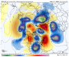
Why is the Polar Vortex down in Mexico?

what happens if after all this rain this weekend the cold disappears to mid feb or doesn’t even show on the models do we go back to square one?But but but winters over? Righttttt?!?!?! ??? Gfs now getting in the back of the line with the euro and geps
Along with the people who followed it
That’s the thing the Gfs is playing catch up big time to the already superior EURO the euro has had all of that shifted East for a while now .. look at the euro not the Gfs .. that should go without saying at this pointI can't say that I'm a fan of that verbatim. Everything needs to shift east a good clip. I know we don't live at H5 but I hate positive heights over the south east pushing the storm track to Chicago. I know we can get overunning/CAD, but it's just not my cup of tea.
I don't understand why the GEFS MJO forecast looks good long range but it's H5 set up still kinda stinks. Perhaps we're not in view of phase 7 yet.
Not being modeled right now so I don’t take into considerationwhat happens if after all this rain this weekend the cold disappears to mid feb or doesn’t even show on the models do we go back to square one?
Yeah, what I posted was just an anomaly map.That is not the tropospheric PV...that is just a deep upper low digging very far south. The trop PV on the op GFS run was fractured and spread out...the deep purples.
View attachment 29969