• Hello, please take a minute to check out our awesome content, contributed by the wonderful members of our community. We hope you'll add your own thoughts and opinions by making a free account!

Wintry Potential Dec 13-14 Ice Threat

WINTER WEATHER ADVISORY IN EFFECT FROM MIDNIGHT TONIGHT TO
7 PM EST FRIDAY...

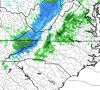
* WHAT...Freezing rain expected. Total ice accumulations of up to
two tenths of an inch.

* WHERE...Portions of central, south central, southwest and west
central Virginia, north central and northwest North Carolina
and southeast West Virginia.

* WHEN...From midnight tonight to 7 PM EST Friday.


Sent from my iPhone using Tapatalk
 
Here's my current thinking on this event. This is going to be a close call for the I-85 corridor, up to a quarter of inch of ice is possible near the blue ridge escarpment. Any freezing rain should transition to all rain once heavier precipitation arrives as latent heating due to freezing & sensible heat fluxes from the warm nose into the underlying CAD dome increase.
December 12-13 2019 NC Forecast Snow Map.png
 
Precip coming in around midnight around here and S piedmont of NC. That could prevent a lot of icing
 
Something the AFD mentions is the UHI in the Charlotte area preventing freezing rain, while I agree that the UHI will probably prevent a lot of areas within Charlotte from being too cold I do think that surrounding suburbs such as Huntersville, Concord, and so on could see some ZR.
 
I did not expect to wake up to 30 degrees and frosty. I think it's actually a little colder than that but thermometer broken. Was suppose to be 35.
 
Mid 20s here. I just checked up against the HRRR and NAM and both are verifying too humid and too warm. Not sure of the implications yet, but it should be watched what the wetbulbs are later tonight before the moisture arrives.
Maybe but almost all modeling always bust with overnight lows in ideal radiational cooling environment but still something to watch. Just doing a quick check and we have a 1040 HP in a pretty good location, yet DP's are in the low to mid 20's, you would really expect to see teen DP's if this was going to be a major winter storm. With that said still looks like a decent nuisance event for the western piedmont/foothills area of NC
 
I moved this post from the Dec thread to over here because it's the same time frame, also as mentioned this map is seriously flawed. I mean temps never even get to freezing in sections of Ga/SC with precip falling and yet it paints 2-4"... crazy clown maps
 
Just throwing these maps out there for comparison, to each model and to verification....

GFS
1576156912249.png

3k NAM

1576157105219.png

and a sounding for that pocket of heavy zr in NE Ga, 31 with heavy rain will be lots of runoff (warm layer fairly stout too) so I'd take those totals with a grain of salt imo
1576157203211.png

RGEM (cold bias and all ;)) has come down on it's totals, this will probably adjust more accurately as the day progresses

1576157303296.png

and finally the long range HRRR

1576157399860.png

Oh and the Euro (although admittedly not in it's wheelhouse at this stage of the game)

1576157494851.png
 
Another definite uptick in ice totals on 3k NAM at 12Z
zr_acc.us_ma.png
 
Another worrisome part to me is how much the HRRR is already showing for that immediate escapement. HRRR is a model that is horrible with 2m temps, usually a couple degrees too warm.
For you guys that are better with the micro-climate out there, how does Hickory usually fair in these setups? I'm asking because I've got some work related travel tomorrow morning to Hickory, thanks
 
For you guys that are better with the micro-climate out there, how does Hickory usually fair in these setups? I'm asking because I've got some work related travel tomorrow morning to Hickory, thanks
Hickory proper does pretty well as it sits on the NW end of Catawba county. I’d say a line from upper Cleveland county towards hickory and up toward wilkesboro and NW or there will do pretty well. It’s treading a fine line of getting the precip in time before the wedge erodes which is why I think winston and Greensboro may not do as well as normal being that far north.
 
Dewpoints just don’t seem to be very low right now and that could certainly affect wet-bulbing late tonight and tomorrow morning. I just looked and dew points are in the 20s throughout NC and VA with 10s up in PA. I would think that those 10s would need to be down into VA to really see good evaporational cooling.
 
Dewpoints just don’t seem to be very low right now and that could certainly affect wet-bulbing late tonight and tomorrow morning. I just looked and dew points are in the 20s throughout NC and VA with 10s up in PA. I would think that those 10s would need to be down into VA to really see good evaporational cooling.

Agree 100% DPs not low enough for good WB. Also RNK was going with lows in the upper 20s tonight now they say lower 30s, BIG deal when talking ZR and potential problems. If it’s low 30s it’s just barely going to be a nuisance IMO!


Sent from my iPhone using Tapatalk
 
I know it's not going to be icy here, but we are 27 here and our low was supposed to be 33.

Likewise, as I know it won't be icy here either, but the temp dipped to 32 at one point in the early morning hours (the low was only supposed to be 40 if I remember correctly).
 
High today is 49 up to 39 already. Humidity is dropping NE winds are picking up now at 9 mph and dew point has dropped from 28 an hour ago to 23 now. It should be interesting next several hours seeing how high temps get before clouds move in and how low dew points can get.
 
Too localized to issue a Winter Storm Warning but southern Wilkes looks somewhat promising to see 0.25” above 2,500ft. Some mountain areas may do poorly if sleet eats away at ZR totals (Watauga/Ashe). I see the AFD mentions 0.1 to 0.2 sleet.
 
1 mPING report of rain hitting the ground so column is moistening in Georgia already. Quicker it gets here the better chance a 1 or 2 hour window exists for sleet north of i40 or northern mtns. 4F436909-DBC5-481D-9109-9B3B7FE548DC.jpeg
 
Maybe a small backside chance of a mix too on the NAM. Mtns should easily get snow showery. Interesting thump of moisture develops over the foothills late Saturday going into the Piedmont. Not there yet but wouldn’t rule out a sneaky surprise of something other than rain.
 

Attachments

  • D5CAEB2A-B89D-469E-AD0F-B188BF5B0DC8.jpeg
    D5CAEB2A-B89D-469E-AD0F-B188BF5B0DC8.jpeg
    203.4 KB · Views: 26
Dewpoints just don’t seem to be very low right now and that could certainly affect wet-bulbing late tonight and tomorrow morning. I just looked and dew points are in the 20s throughout NC and VA with 10s up in PA. I would think that those 10s would need to be down into VA to really see good evaporational cooling.
Actually DPs are lower than forecast so far.

Sent from my Z983 using Tapatalk
 
HRRR has been getting more chilly in CAD areas, moisture is close, but you can also see latent heat release from raindrops to our south and how better precip rates actually warm it up a bit in GAhrrr_T2m_seus_fh10_trend.gifHRRR may just show plain rain, but WBZs are definitely supportive of initial ZR, for example this sounding north of CLT, 33 degrees but that WBZ is supportive of a temp around 30 degrees, and note that moist layer from 700mb to 900mb, this is supportive of drizzle already, and dew points are already running to high, that could make a decently big difference, for example instead of 33/26 which WBZ equals 30.7, if you get the dew point a bit lower, like 33/23, your WBZ is now 29.7, its little things like this that makes a big difference1576174800120.png
 
Back
Top