• Hello, please take a minute to check out our awesome content, contributed by the wonderful members of our community. We hope you'll add your own thoughts and opinions by making a free account!

Pattern Fabulous February

If you can appreciate the beauty of a La Nina-like stubborn SE ridge, you'll enjoy the 12Z GEFS.

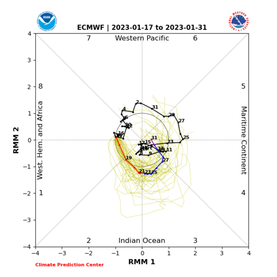
With an MJO chart like this, I was surprised the 6z was as good as it was. 12z makes more sense considering the phase it's got it going to, western trough/SE ridge. Smart minds say this turn back to phase 6 is not going to happen. I don't know, it's wanted to be over that way this winter. We'll see soon. Euro doesn't agree.

Again, I just get this feeling that everything the weeklies, CFS, etc pointed too in regard to blocking and -NAO is going to come back around right in time for March again, like it has the last couple years. I really think persistence forecasting is the new way to go for our winters.

1549042019187.png
 
Here comes the winter storm that I was talking about in the banter...only a day later than what I was predicting on the FV3.
dc3a13ee2c71e0aced0ad03f107eb7ae.jpg
 
Here comes the winter storm that I was talking about in the banter...only a day later than what I was predicting on the FV3.
dc3a13ee2c71e0aced0ad03f107eb7ae.jpg
You want it earlier. By 330, the 50/50 is pulling out, confluence is lifting north, and the wave will start moving north. Let's see if that happens when the next frames come out. In either case, the whole height field will probably be well north by then anyway.
 
You want it earlier. By 330, the 50/50 is pulling out, confluence is lifting north, and the wave will start moving north. Let's see if that happens when the next frames come out. In either case, the whole height field will probably be well north by then anyway.
It doesn’t matter H5 will change drastically each cycle at this lead...
 
Having a + PNA always trumps only having a -NAO for the SE. I will always choose a +PNA over any tc/signal. That post from Ventrice is a good example of why.

Agreed, give me a +PNA and I'll take my chances here in the south. The -NAO is nice but I personally have seen better success from the +PNA and -EPO combo. Unfortunately the +PNA has been scarce this winter and looks to remain that way.
 
the apple weather app seems to be hitting the liquor cabinet. Does anyone know why those flakes would suddenly appear?
.21E43902-7235-46D6-970F-F0AE46328627.png
 
Having a + PNA always trumps only having a -NAO for the SE. I will always choose a +PNA over any tc/signal. That post from Ventrice is a good example of why.

Agreed, give me a +PNA and I'll take my chances here in the south. The -NAO is nice but I personally have seen better success from the +PNA and -EPO combo. Unfortunately the +PNA has been scarce this winter and looks to remain that way.

I'm not sure. I always refer to this study.

https://climate.ncsu.edu/climate/patterns/nc-snowfall
 
The Euro shows a pretty strong HP dropping down at 192, anyone with precip maps? This looks like it would be an icy setup for someone if there is moisture moving in.
View attachment 14641

No precip then (hour 192) on this 12Z Euro. Also, virtually no wintry precip SE US entire 10 days. But the one good thing is that this run looks much better than that crapfest at the end of the last run.

Man, I hate -PNAs!!
 
Screw looking at d8+ fantasy snows or surface maps, what may be of more immediate concern is the potential for some thundestorms and/or severe weather across the Arklatex region and/or lower Mississippi Valley later next week. As @Myfrotho704_ showed in the other thread, this definitely looks interesting to say the least and fits in general w/ the longwave pattern and our increasingly favorable severe climo that begins to ramp up in February. The weathermodels maps also showed some appreciable CAPE, deep layer shear, etc. but as usual in the front half of the severe season, CAPE will likely be the limiting factor here if severe weather is going to occur.

This is only about 5-6 days out so worth monitoring going forward.

This system is on the SPC's radar
" A larger-scale trough will
seemingly develop over the western U.S. on Tuesday before moving
eastward into the Great Plains Wednesday (day 6) and OH/TN Valleys
on Thursday (day 7). Considerable model run-to-run variability is
apparent by mid week but increasing Gulf moisture will likely reside
ahead of this system in the Mid-South/lower MS Valley."


ecmwf_mslp_uv850_us_7.png
 
Back
Top