Going to call my heating and air guy out tomorrow to make sure the AC is ready for winter. I tested its limits in the last 90 daysYeah, west of the Apps gets 2-4” of rain, we barely get an inch through Sunday! Stalled fronts rock, and it’s suppo to get to 91 tomorrow! We are winning so hard !
-
Hello, please take a minute to check out our awesome content, contributed by the wonderful members of our community. We hope you'll add your own thoughts and opinions by making a free account!
You are using an out of date browser. It may not display this or other websites correctly.
You should upgrade or use an alternative browser.
You should upgrade or use an alternative browser.
Pattern September Somnolence
- Thread starter setxwx
- Start date
Runner cutter stalled front. This heat has me confused. I give up
We replaced our 20 year old unit last year! It’s definitely made a huge differenceGoing to call my heating and air guy out tomorrow to make sure the AC is ready for winter. I tested its limits in the last 90 days
Brent
Member
cold front plowing through OKC right now... gonna struggle to stay a tomorrow with a strong north wind and may have 50s tomorrow night... saying good riddance to summer here
cold front plowing through OKC right now... gonna struggle to stay a tomorrow with a strong north wind and may have 50s tomorrow night...saying good riddance to summer here
Enjoy for us...cause it's clearly not coming here anytime soon lmao
Nice heavy rain shower to start the day! First measurable since Florence!!
I hear ya. Got some wicked lighting here before daylight. Unreal!!!Nice heavy rain shower to start the day! First measurable since Florence!!
pcbjr
Member
This amends the post made yesterday, here ... http://southernwx.com/community/threads/september-somnolence.417/page-17#post-111740
The data I used came from Intellicast; the historic data was woefully incorrect, which, of course, made the post likewise. Larry was kind enough to point that out to me via PM. So, 4 things:
1) The post is factually incorrect;
2) Larry is a true gentleman (and a scholar) for letting me know the error privately;
3) The original post is not being deleted since the qualitative sentiment of "don't lose hope" stands ... ; and
; and
4) Don't rely on Intellicast for historic data.
Phil
The data I used came from Intellicast; the historic data was woefully incorrect, which, of course, made the post likewise. Larry was kind enough to point that out to me via PM. So, 4 things:
1) The post is factually incorrect;
2) Larry is a true gentleman (and a scholar) for letting me know the error privately;
3) The original post is not being deleted since the qualitative sentiment of "don't lose hope" stands ...
4) Don't rely on Intellicast for historic data.
Phil
B
Brick Tamland
Guest
Word on the street is there could be some storms around here tonight.
Just a tick over 4 inches since Midnight in McCalla (I59/20 and I459) interchange in the B'ham Metro. Training right through central AL most of the day.
Lots of rain here, but still going around my house. Rain shield still working strong.
Brent
Member
62 and sunny here. It was pouring rain at 230pm and was 90 yesterday lol

Strike 1View attachment 6590 Let’s see how many ways we can get whiffed tonight!??
Well it’s rain here for most of the day and just stopped. But now it muggy.!!lol winning!!!
CentralGAColdFront
Member
I haven't received any rain at my location for the past two weeks. Additionally, temperatures have been brutal SE of this stalled front. Outside of 2002, I can never remember a "summer' that just seemingly would never end.
B
Brick Tamland
Guest
A strong storm coming through Carrboro now. Looks like things are starting to fire up around here.

Strike 2! We rock at rain!View attachment 6591
Strike 1

Big whiffed now! Strike 3! This is how you 80% chance of rain!View attachment 6593
Strike 2! We rock at rain!
We did ok. Areas from Willington to Ninety Six got completely blankedView attachment 6593
Strike 2! We rock at rain!
I got less than .10We did ok. Areas from Willington to Ninety Six got completely blanked
whatalife
Moderator
Well that was fun. I just picked up a quick 1.25” of rain in about 30 minutes time.
Sent from my iPhone using Tapatalk
Sent from my iPhone using Tapatalk
GeorgiaGirl
Member
Stormed twice today, once while I was out and again at night.
Raleigh Hazardous Outlook for Triad -
"A few strong to severe thunderstorms are possible late this afternoon
through this evening. The primary severe weather hazard will be
locally damaging wind gusts. An isolated tornado cannot be ruled
out, mainly along and north of highway 64. The severe weather threat
appears to be highest between 4 PM and 11 PM."
B
Brick Tamland
Guest
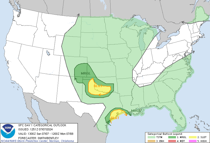
Might have some fireworks later this afternoon and tonight. Under a marginal risk right now. Really wish they would combine marginal/slight, and enhanced/moderate, though.
Day 1 Convective Outlook
NWS Storm Prediction Center Norman OK
0749 AM CDT Thu Sep 27 2018
Valid 271300Z - 281200Z
...THERE IS A MARGINAL RISK OF SEVERE THUNDERSTORMS PARTS OF GA TO
SOUTHERN VA...
...SUMMARY...
Isolated damaging winds are possible between about 3 PM to 12 AM EDT
from parts of Georgia to southern Virginia. Potential for a brief
tornado exists mainly this evening in parts of southern Virginia and
northern North Carolina.
...Carolinas/eastern GA/southern VA...
Primary change this outlook is to slightly expand the Marginal risk
north across southern VA given variance among guidance with the
northward extent of surface-based instability this evening.
Low-amplitude shortwave trough over the Ozarks will rapidly eject
into the Mid-Atlantic States by Friday morning. Attendant weak (1014
mb) surface cyclone over central MS should track northeast along a
quasi-stationary front and reach the southwest VA border area by
late evening. Surface temperatures warming into the 80s are
anticipated across most of the Piedmont/Coastal Plain of the
Carolinas/GA by afternoon, supporting scattered storm development.
While hodographs will generally remain small, 700-500 mb
southwesterlies will strengthen to between 25-40 kt with approach of
the shortwave trough. A few multicell clusters and a couple
transient supercells are expected into early evening with isolated
strong wind gusts being the primary hazard.
Enlarging low-level hodographs are anticipated after sunset as
southwesterlies increase atop the slowly advancing warm front from
the VA/NC border. Guidance differs with the degree of surface-based
instability near/south of the boundary and this will be a key factor
to the potential supercell tornado risk into late evening. Even so,
given the lack of cyclogenesis and unfavorable timing with regard to
the diurnal heating cycle, overall storm coverage may be more
limited in this time frame.

.Raleigh Hazardous Outlook for Triad -
"A few strong to severe thunderstorms are possible late this afternoon
through this evening. The primary severe weather hazard will be
locally damaging wind gusts. An isolated tornado cannot be ruled
out, mainly along and north of highway 64. The severe weather threat
appears to be highest between 4 PM and 11 PM."

Sent from my SM-G920V using Tapatalk
Nice supercell popping a tor warning
Sent from my SM-G955U using Tapatalk
Sent from my SM-G955U using Tapatalk
B
Brick Tamland
Guest
Nice supercell popping a tor warning
Sent from my SM-G955U using Tapatalk
Where?
It was in Richmond and Montgomery counties. Really weakened as it moved NE. Wouldn't be shocked to see another tor warning this evening across the areaWhere?
Sent from my SM-G955U using Tapatalk
That line is moving right at us! It’s got that look to it
Tornado warning near Anderson!!That line is moving right at us! It’s got that look to it
Confirmed on the ground!Tornado warning near Anderson!!
Confirmed tornado NW of Anderson
Hunker down Mack!Confirmed on the ground!
BHS1975
Member
Couplet looks weak now
Sent from my iPhone using Tapatalk
Sent from my iPhone using Tapatalk
Lake Hartwell made it possible. That’s what CJ saidCouplet looks weak now
Sent from my iPhone using Tapatalk
If I hear him say “ outrun the line” or the “ lake caused the tornado “ I’m going to pimp slap him! Moving safely to my NW, but still gonna be a good storm!Lake Hartwell made it possible. That’s what CJ said


