B
Brick Tamland
Guest
That's fine. I'll take 3 inches in March. Would be more than we got the last storm in January.Yeah the pivotal maps are much more realistic
Sent from my iPhone using Tapatalk
That's fine. I'll take 3 inches in March. Would be more than we got the last storm in January.Yeah the pivotal maps are much more realistic
Sent from my iPhone using Tapatalk
Which pivotal map ? The one you posted looks much better than the one shawn posted.Yeah the pivotal maps are much more realistic
Sent from my iPhone using Tapatalk

Which pivotal map ? The one you posted looks much better than the one shawn posted.


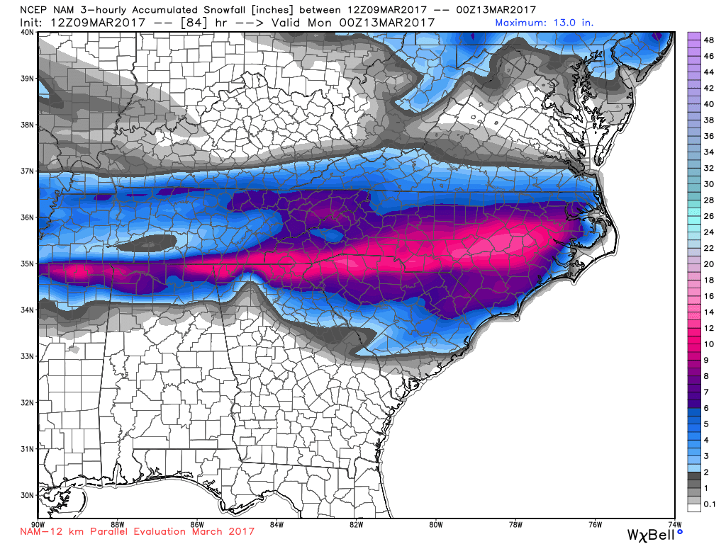
Storm may need to go to chattanoogaOh, if only the para-nam 12k...
Storm may need to go to chattanooga
Oh, if only the para-nam 12k...

So Shawn do you think Columbia have a chance to see some snow 12z Nam have trended South with the Low Pressure? I think their is a good chance we could!!That PARA NAM is mostly mixed crap in SC outisde the far northern tier and gsp area.
So Shawn do you think Columbia have a chance to see some snow 12z Nam have trended South with the Low Pressure? I think their is a good chance we could!!
If that High Pressure builds in quicker and the wedge is always underdone on models so you never know, March can throw in some surprises.Temps suck tbh. I still like the Rock Hill area being the cut off for actual snow. Maybe Laurens, POSSIBLY Northern Newberry.
The low placement is really going to screw us in the long run. The 850s will likely rise and end up giving us a chilly rain or sleet when all is said and done. I'm awaiting the 12z GFS/GEFS and Euro still, but I just can't get on board this far South at this point. I'd like to see a "big hit" over the Midlands to get excited that has GEFS support. It's lacking, and even the EPS for the CAE area last night went from an okay event to basically flurries at best.If that High Pressure builds in quicker and the wedge is always underdone on models so you never know, March can throw in some surprises.
Lol. It's still winter according to the calendar.I for one think this sucks. I don't want cold rain or snow. It is spring now. But as usual we will get the worst of it. Being cold rain. The freaking worst. I say it should all miss us.
Idc care about no stinking calendar.Lol. It's still winter according to the calendar.
Move to Florida!Idc care about no stinking calendar.


")