W
WSW
Guest
NO severe weather please.I like to give it bout February 17 …. Been my cutoff date chasing winter storms for my area … then bring on my spring severe weather ….
NO severe weather please.I like to give it bout February 17 …. Been my cutoff date chasing winter storms for my area … then bring on my spring severe weather ….
Around the 20th book it!!!So, what we gather from the data is this, if it doesn't snow in January, then February and March are off the table as well. Interesting that Webber is going against data that is 150 years old. Bet he is banking on us getting some snow that last week in January.
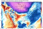
Gets cold at hour 384The surface look one day farther would be encouraging:
View attachment 139352

Hey man I hate to break it to you but if you are doing greens you really shouldn’t plant any later than October if you want to be picking collards in December! Smh. No wonder your yard always looks so deadI stop looking for snow around Thanksgiving and get the garden planted by Christmas
The creasy greens are already coming up. It’s usually late Jan before they doHey man I hate to break it to you but if you are doing greens you really shouldn’t plant any later than October if you want to be picking collards in December! Smh. No wonder your yard always looks so dead
Feels like it's always about getting lucky when it comes to getting snow here.
Yes and doesnt matter if mjo is in phase 1 2 3 4 5 6 7 8, cod. For years its always an aurgument for whatever phase it is in verse whatever background state, not favorable. Seriously the needle moves so much,dont even know what to root for mjo wise.So I guess the SSWE is just a pipe dream now?
It happenining but it doesn't look like the spv will split instead it'll just be bumped around/elongated/weakened. Better than it spinning like a top over the pole but really takes a little shine off my late Jan and Feb expectations. It'll be interesting to see if another warming takes shape around week 2/3 which for our location wouldn't be terrible for mid to late febSo I guess the SSWE is just a pipe dream now?
Welcome to the south eastern part of the country lolFeels like it's always about getting lucky when it comes to getting snow here.
Well that’s always the truth on this boardFeels like it's always about getting lucky when it comes to getting snow here.

Well I mean it is the SE, What do you really expect?Feels like it's always about getting lucky when it comes to getting snow here.
Needing to be lucky is like a national thing lately, not just the SE. Vast majority of the country in the same boat.
View attachment 139442
View attachment 139443
Um…where is the place with 300 feet of snow cover?Needing to be lucky is like a national thing lately, not just the SE. Vast majority of the country in the same boat.
View attachment 139442
View attachment 139443
don’t think many want to hear this, but later week 1-week 2 of jan and maybe even a little further past that, it doesn’t look pretty pattern wise. Tropical forcing looks to slow significantly for a while in the Indian Ocean due to the weakening +IOD, which will give it more oomph as well. (basically the IO losing influence from the El Niño). The MJO slowing over the Indian Ocean for the next week and beyond is gonna favor a retracted pacific jet past next week and the semi-permanent Okhotsk low, which favors GOAK ridging/-PNA. Given the HLB/-NAO, the SE ridge might be put at bay at times, but it probably will show up at times. It’s honestly a pretty nina esque look
Feels like it's always about getting lucky when it comes to getting snow here.
can remember good ole winters before climate change came...it wasnt hard get good snows then, just matter of how many vs will it snow now these days.Timing is the only Holy Grail of Winter Weather in the SE !
Timing is and always will be more crucial than any pattern.
I'll die on that hill...
Yikes is right. Not trending in the right direction.
I would really love to figure out why this tends to happen. It seems to me that we regularly default to a nina like Aleutian Ridge/Western trough H5 pattern no matter the enso state the last decade.
This year, it's already being discussed around the web that, although this is a strong nino, there's competing forcing that mutes the enso and has shown nina like forcing. So why is that? Is it the overall hot oceans? Northern pacific heat causing ridging there? Constant indian ocean heat? This warming of the oceans has me thinking that perhaps we may be living in a time period that has no analog past the last 10 years or so. And that what we're seeing is the new normal.
The same physical processes working to retract the Pacific Jet Stream & generate Western Canada blocking/+PNA in early January will also try to drop a mean trough over the western half of the CONUS as we approach mid-January.
Although the prototypical -PNA pattern will be significantly muted & smeared in this case for obvious ENSO-related reasons (i.e. I wouldn't expect a particularly persistent or intense SE US ridge here (if at all)).... ...this large-scale signal is definitely legit, esp. given the forthcoming collapse of the +IOD that'll help enhance the expression of Indian Ocean-related convective + downstream circulation anomalies.
This is the kind of pattern we need to see to restore the snow pack over the northern tier of the US going into our prime window for winter weather (late Jan-early Feb)
View attachment 138775
View attachment 138778
View attachment 138776
View attachment 138777
System tried to cut at first which was pretty hilariousI’d there’s one thing consistent, it’s the mountains getting a hit off this system View attachment 139447View attachment 139448View attachment 139449
Getting picked up off waveguide by the deep trough in the western USSystem tried to cut at first which was pretty hilarious
good to be located in the higher elevtions in strong nino wintersI’d there’s one thing consistent, it’s the mountains getting a hit off this system View attachment 139447View attachment 139448View attachment 139449
Yeah, the SLP also jumped all over the place once it entered the coast at HR 120.System tried to cut at first which was pretty hilarious
In case you missed this post from 11 days ago.
Finally below 32 for a change.I’d there’s one thing consistent, it’s the mountains getting a hit off this system View attachment 139447View attachment 139448View attachment 139449
Colder than previous run. Still some snow for parts of Virginia.View attachment 139459
No cold air on the Euro
ALWAYS good to be at some elevation.good to be located in the higher elevtions in strong nino winters
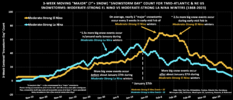
That analysis is for the Mid Atlantic and Northeast. What about the southeast and deep south?Here's another nice graph, but now showing 3-week moving average "major" snowstorm count for the mid-Atlantic & NE US for moderate-strong El Niño & La Niña winters only.
We don't usually flip the script towards cold/snowy in Nino winters like this til about the last week of January.
I.e. the clock doesn't really start ticking to score big dogs in winters like this til about January 25th or so.
People need to take a chill pill.
View attachment 139444
The Carolinas aren’t much differentThat analysis is for the Mid Atlantic and Northeast. What about the southeast and deep south?
